Probability of damaging thunderstorm winds or wind gusts of 50 knots or higher within 25 miles of a point. Hatched Area: 10% of greater probability of wind gusts 65 knots or greater within 25 miles of a point.
SPC AC 131258
Day 1 Convective Outlook
NWS Storm Prediction Center Norman OK
0758 AM CDT Wed Apr 13 2022
Valid 131300Z - 141200Z
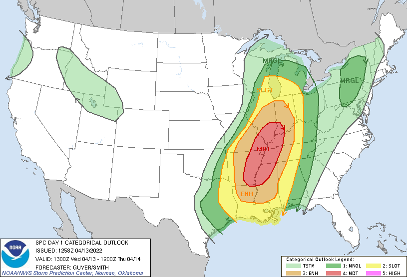
...THERE IS A MODERATE RISK OF SEVERE THUNDERSTORMS ACROSS PORTIONS
OF AR/MS/TN/MO/IL/IN/KY...
...SUMMARY...
Numerous severe thunderstorms are expected today across the
Mid-South and lower/middle Mississippi Valley and Midwest.
Tornadoes, some of which will be strong, widespread and potentially
significant damaging thunderstorm winds, and large hail are likely
especially within the Moderate and Enhanced Risk areas.
A severe-storm outbreak is expected today into tonight. Widespread
severe storms are likely across a very broad north-south region from
the Lower Mississippi Valley and Mid-South into the Midwest, with
atmospheric ingredients favorable for all severe hazards, including
potentially significant/intense severe storms.
...Mid-South/Lower to Middle Mississippi Valley/Midwest...
An upper trough, with its axis centered over the High Plains early
today, will eject northeastward toward the Midwest/Ohio Valley, with
a pronounced strengthening of mid/high-level jet stream winds
(80-110 kt) particularly over the Ozarks/Midwest/Ohio Valley. These
strong winds and related height falls/forcing for ascent will
overspread a semi-moist boundary layer (low to middle 60s F surface
dewpoints) across the Midwest ahead of an eastward-moving cold
front, with more consequential moisture availability (upper 60s F)
expected across the ArkLaTex/Mid-South/Lower Mississippi Valley,
where severe/supercell-conducive wind profiles will exist even well
south of the stronger portions of the polar jet.
Speaking to early morning airmass characteristics, pre-dawn surface
analysis in conjunction with 00z and 06z (via PERiLS project)
upper-air analysis/trends reflect some air mass impacts via a
persistent MCS and resultant MCV across western Tennessee and nearby
ArkLaMiss. Observed meso-high and MCS-aftermath dry air in vicinity
of the ArkLaMiss are expected to decay relatively early today,
although these factors cast some uncertainty for the spatial details
of later-day availability of rich moisture. For these reasons, along
with a considerable amount of upstream early day convection/cloud
cover, an upward adjustment to the current Moderate Risk category
does not appear prudent at this time /13z/. That said, regarding the
early day MCV/lingering outflow, an ample moisture reservoir over
east Texas (850 mb dewpoints 12+C) is expected to largely replenish
the broad warm/moist sector into the afternoon (reference 12z
Shreveport LA observed sounding etc.), which will be beneath a
notable eastward-extending elevated mixed layer.
For short-term details across southeast Oklahoma and the ArkLaTex,
see Mesoscale Discussion 471. Regarding central/southern Missouri
and western Illinois in the short-term, see Mesoscale Discussion
472.
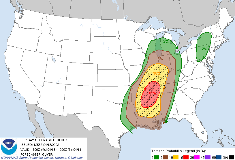
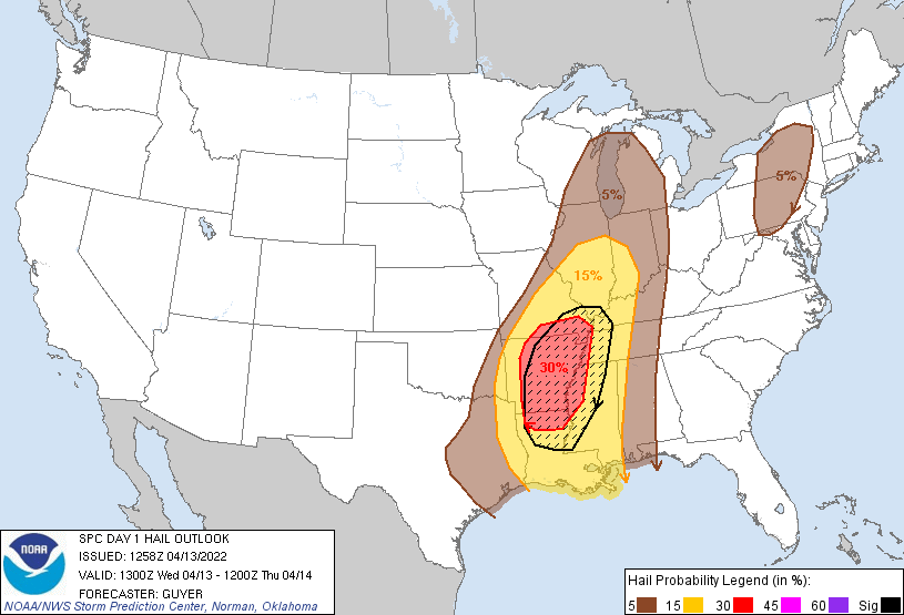
By midday/early afternoon, moderate to strong instability and
steadily weakening CINH will be in place across Arkansas/Louisiana
toward the Lower Mississippi Valley, where model forecasts have
MLCAPE in the 2000 to 3000 J/kg range. Ample deep-layer/low-level
shear will be favorable for supercells, initially capable of large
hail and tornadoes. Discrete supercells ahead of the organizing
squall line will have the potential for strong/intense tornadoes
including some that are potentially long-track, particularly as the
low-level jet further strengthens across the region later this
afternoon into early evening. This corridor of
stronger/longer-duration tornado concern is focused across the
Mid-South/ArkLaMiss vicinity. Otherwise, potentially
widespread/locally significant damaging thunderstorm wind gusts will
also evolve as the squall line organizes, intensifies, and moves
eastward with embedded bowing segments, although QLCS-related
tornadoes can also be expected.
The damaging wind/tornado risk may linger through the
late-evening/overnight hours across portions of Mississippi/Alabama
and southern Louisiana and the Florida Panhandle. This would be via
a persistence of moist and strong/confluent low-level flow, although
850 mb winds are forecast to gradually weaken overnight.
For areas northward into/across Missouri, Illinois, and Indiana, it
appears likely that storms will increase and intensify initially
across southern Missouri, as early as this morning in vicinity of
the outflow-enhanced effective cold front. These storms will pose a
damaging wind and some severe hail risk especially into the
afternoon as they organize and race east-northeastward. The
potential for tornadoes will exist as well, in dual scenarios
including any pre-squall line supercellular development and within
an evolving QLCS itself, especially as storms encounter a
dramatically strengthening south-southwesterly low-level jet (50-60
kt at 850 mb) across southeast Missouri and areas eastward across
Illinois/Indiana/Kentucky. Tornadoes and potentially
widespread/locally significant damaging winds are likely especially
through the afternoon and early/mid-evening hours.
...Northeast States...
Low-level moistening will occur today in the wake of a
northward-shifting warm front, with isolated thunderstorm
development across the region this afternoon expected to be aided by
a northeastward-moving shortwave trough aside from orographic lift.
Weak to locally moderate destabilization across central New York
into central/eastern Pennsylvania may support a few severe storms as
lapse rates diurnally steepen. A few instances of wind damage and
hail would be the primary hazards.
..Guyer/Smith.. 04/13/2022
CLICK TO GET WUUS01 PTSDY1 PRODUCT
NOTE: THE NEXT DAY 1 OUTLOOK IS SCHEDULED BY 1630Z