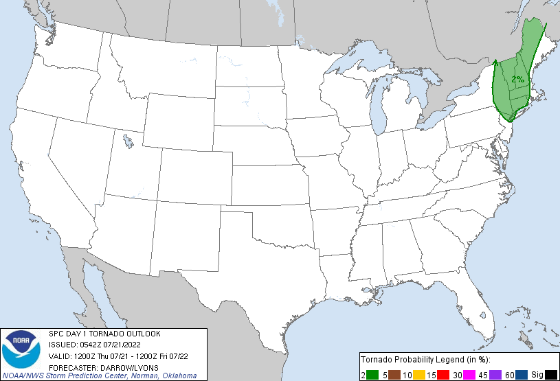
New York, NY...Boston, MA...Virginia Beach, VA...Newark, NJ...Norfolk, VA...
Probabilistic Tornado Graphic
Probability of a tornado within 25 miles of a point. Hatched Area: 10% or greater probability of EF2 - EF5 tornadoes within 25 miles of a point.
Day 1 Tornado Risk
Area (sq. mi.)
Area Pop.
Some Larger Population Centers in Risk Area
2 %
70,199
25,207,392
New York, NY...Newark, NJ...Jersey City, NJ...Yonkers, NY...Worcester, MA...
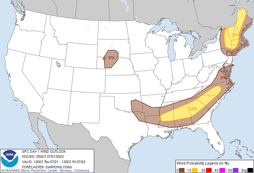
Probabilistic Damaging Wind Graphic
Probability of damaging thunderstorm winds or wind gusts of 50 knots or higher within 25 miles of a point. Hatched Area: 10% of greater probability of wind gusts 65 knots or greater within 25 miles of a point.
New York, NY...Boston, MA...Virginia Beach, VA...Newark, NJ...Norfolk, VA...
Probabilistic Large Hail Graphic
Probability of hail 1" or larger within 25 miles of a point. Hatched Area: 10% or greater probability of hail 2" or larger within 25 miles of a point.
Day 1 Hail Risk
Area (sq. mi.)
Area Pop.
Some Larger Population Centers in Risk Area
5 %
204,457
49,017,195
New York, NY...Charlotte, NC...Boston, MA...Atlanta, GA...Raleigh, NC...
   SPC AC 210542

   Day 1 Convective Outlook
   NWS Storm Prediction Center Norman OK
   1242 AM CDT Thu Jul 21 2022

   Valid 211200Z - 221200Z

   ...THERE IS A SLIGHT RISK OF SEVERE THUNDERSTORMS ACROSS THE
   NORTHEAST AND THE SOUTHEAST...

   ...SUMMARY...
   Scattered severe thunderstorms capable of producing mainly damaging
   wind gusts appear possible over parts of the Northeast and Southeast
   on Thursday.

   ...Northeast...

   Short-wave trough will eject across the lower Great Lakes/upper OH
   Valley into western QC, glancing New England as it ejects into the
   Maritimes late in the period. Latest model guidance remains
   consistent in allowing strong boundary-layer heating across NY into
   northern ME by 18z ahead of the surface front. This corridor of
   strong heating will result in modest destabilization with upwards of
   2000 J/kg SBCAPE prior to convective initiation. Forecast flow/shear
   support isolated supercells, and more complex organized clusters and
   line segments capable of generating damaging winds and perhaps some
   hail. Forecast soundings suggest convective temperatures will be
   breached by 17-18z, and scattered thunderstorms should evolve ahead
   of the front shortly thereafter. With strongest forcing expected to
   spread north of the international border, trailing convection should
   become more isolated across southern New England. Thunderstorms
   should spread east of the region and/or weaken after sunset over
   Downeast ME.

   ...Southeast...

   Early this morning, a cluster of thunderstorms was slowly organizing
   over southern KY along the southwestern flank of the Great Lakes/OH
   Valley short-wave trough. Northwest flow is expected to increase
   into the southern Appalachians by mid day as the short wave
   progresses east of the higher terrain. Remnants of this
   early-morning complex should progress across eastern TN toward
   northern GA. Additional convection will likely evolve/redevelop
   along surging outflow, and later in the day along the primary
   synoptic front that will sag across the TN Valley into the mid South
   region. Strong buoyancy and adequate flow aloft should provide
   enough storm-layer shear for some storm clustering. In addition to
   some wet microburst potential, organized clusters could also
   generate gusty winds.

   ...High Plains of SD/NE...

   Strong boundary-layer heating will contribute to hot surface
   temperatures that will mitigate capping across portions of SD/NE by
   late afternoon. Weak surface boundary is expected to drape across
   the NE Panhandle into south-central SD, and this may provide the
   focus for a few high-based storms. If storms can initiate, the LLJ
   is forecast to increase across NE after sunset. This may support a
   few longer-lived updrafts into the evening hours.

   ..Darrow/Lyons.. 07/21/2022

   CLICK TO GET WUUS01 PTSDY1 PRODUCT

   NOTE: THE NEXT DAY 1 OUTLOOK IS SCHEDULED BY 1300Z