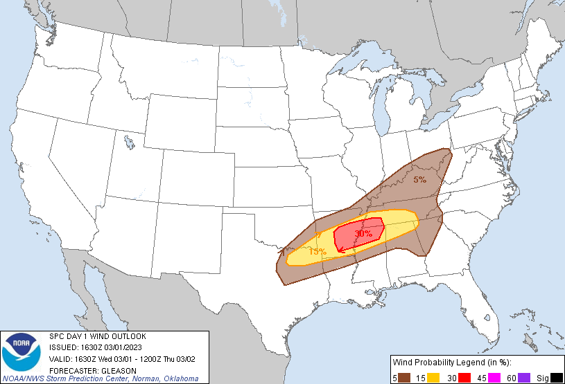
Probability of damaging thunderstorm winds or wind gusts of 50 knots or higher within 25 miles of a point. Hatched Area: 10% of greater probability of wind gusts 65 knots or greater within 25 miles of a point.
Day 1 Wind Risk
Area (sq. mi.)
Area Pop.
Some Larger Population Centers in Risk Area
30 %
29,028
2,844,760
Memphis, TN...Little Rock, AR...North Little Rock, AR...Pine Bluff, AR...Conway, AR...
Fort Worth, TX...Nashville, TN...Cincinnati, OH...Louisville, KY...Birmingham, AL...
SPC AC 011630
Day 1 Convective Outlook
NWS Storm Prediction Center Norman OK
1030 AM CST Wed Mar 01 2023
Valid 011630Z - 021200Z
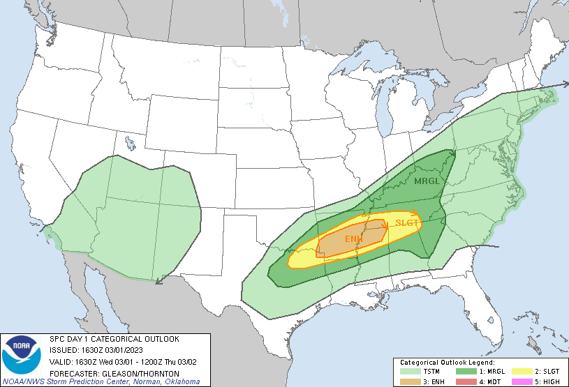
...THERE IS AN ENHANCED RISK OF SEVERE THUNDERSTORMS FROM PARTS OF
THE ARKLATEX INTO THE MID-SOUTH...
...SUMMARY...
A focused corridor of severe potential is evident this afternoon
through tonight from northeast Texas into the Mid-South and
Tennessee Valley. Scattered large to very large hail, damaging
winds, and tornadoes all appear possible. A strong tornado may also
occur.
...Southern Plains into the Mid-South and Tennessee Valley...
A broad area of enhanced southwesterly mid-level flow will persist
today through tonight across the southern Plains into the MS Valley
and OH Valley. At the surface, a front extends from north TX into MO
and the Midwest. Low-level moisture is forecast to gradually
increase this afternoon and evening along/south of this boundary. A
strong cap noted on the 12Z SHV sounding should inhibit robust
convective development for at least a few more hours. Eventually,
subtle large-scale forcing associated with a low-amplitude mid-level
perturbation over TX, along with modest low-level convergence along
the front, should support convective initiation over northeast
TX/the ArkLaTex region by late this afternoon.
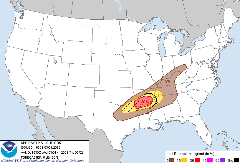
Steep mid-level lapse rates, increasing low-level moisture, and
filtered daytime heating should support moderate instability in a
narrow corridor from northeast TX into the Mid-South. Deep-layer
shear in excess of 50 kt will easily support organized
thunderstorms, including supercells. Scattered large to very large
hail will be threat with any initially discrete convection that
develops. With time, thunderstorms should congeal into one or more
bowing line segments as they spread eastward across the Mid-South
and TN Valley this evening and tonight. The damaging wind threat
should increase across these areas as this mode transition occurs.
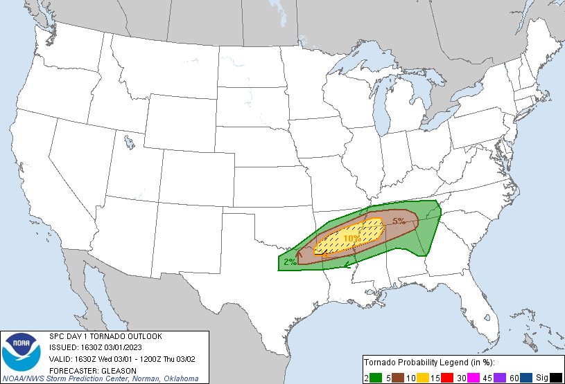
While there is still some uncertainty, most guidance also suggests
that a southerly low-level jet will modestly strengthen this evening
to around 30-35 kt. A narrow zone of more favorable tornado
potential may exist across parts of southern/central AR into
northern MS and southwestern TN, particularly if supercells can
remain at least semi-discrete. A strong tornado appears possible in
this corridor. Based on consensus of 12Z guidance, confidence has
increased in a more concentrated corridor of severe potential across
this region, warranting the addition of an Enhanced Risk.
...Ohio Valley...
The cold front should advance quickly east-southeastward across the
OH Valley through this evening. Low-level moisture will remain more
limited compared to locations farther south. Still, steep lapse
rates and ample daytime heating ahead of the front should aid in the
development of weak instability this afternoon. Isolated strong to
severe thunderstorms capable of producing both hail and damaging
winds appear possible.
..Gleason/Thornton.. 03/01/2023
CLICK TO GET WUUS01 PTSDY1 PRODUCT
NOTE: THE NEXT DAY 1 OUTLOOK IS SCHEDULED BY 2000Z