San Antonio, TX...Austin, TX...Little Rock, AR...Waco, TX...Killeen, TX...
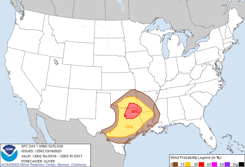
Probabilistic Damaging Wind Graphic
Probability of damaging thunderstorm winds or wind gusts of 50 knots or higher within 25 miles of a point. Hatched Area: 10% of greater probability of wind gusts 65 knots or greater within 25 miles of a point.
San Antonio, TX...Austin, TX...Shreveport, LA...Waco, TX...Killeen, TX...
5 %
95,927
10,636,688
Houston, TX...Oklahoma City, OK...Tulsa, OK...Pasadena, TX...Beaumont, TX...
SPC AC 161259
Day 1 Convective Outlook
NWS Storm Prediction Center Norman OK
0759 AM CDT Thu Mar 16 2023
Valid 161300Z - 171200Z
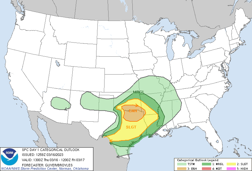
...THERE IS AN ENHANCED RISK OF SEVERE THUNDERSTORMS ACROSS SOUTHERN
OKLAHOMA/NORTH TEXAS AND FAR SOUTHWEST ARKANSAS...
...SUMMARY...
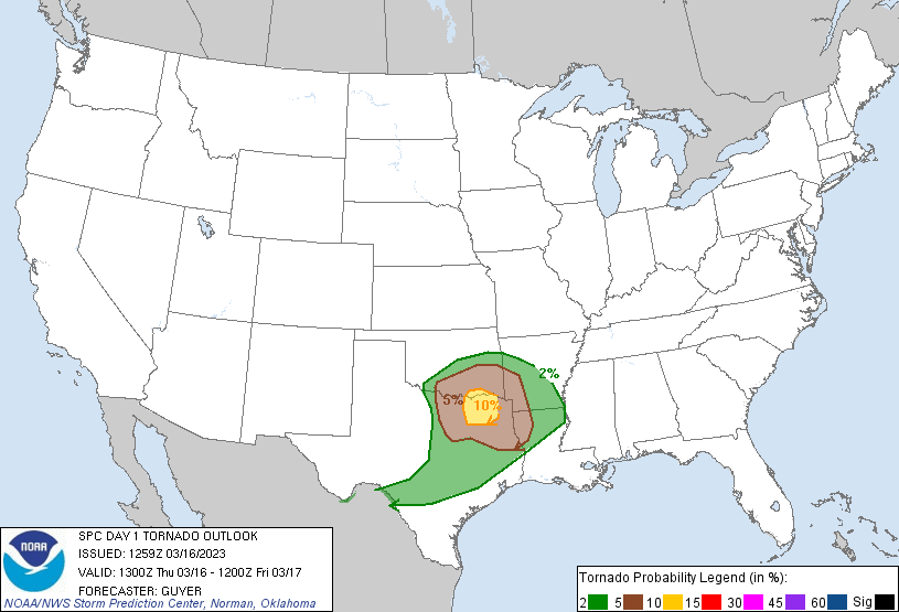
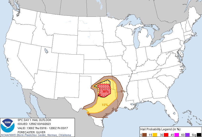
Scattered severe thunderstorms capable of producing large hail,
damaging winds, and a few tornadoes are likely this afternoon and
evening across parts of the southern Plains. Some of the hail could
be very large over southern Oklahoma and north-central Texas.
...Southern/Eastern Oklahoma and Central/North Texas...
Emerging from split flow over the West, a low-amplitude shortwave
trough and mid/high-level speed max centered along the Arizona/New
Mexico/International border vicinity early this morning will
steadily influence the region into mid/late afternoon. Low-level
moisture will stream north-northeastward today, with lower 60s F
surface dewpoints quickly becoming established into southern/eastern
Oklahoma and the ArkLaTex, and middle 60s F across central/east
Texas. This will be to the east of a surface trough/dryline, and to
the southeast of a cold front that will steadily progress
southeastward and overtake the dryline from north to south through
tonight.
Within the warm sector, diurnal heating will promote moderate to
locally strong destabilization with MLCAPE of 1500-2500 J/kg in the
presence of relatively steep mid-level lapse rates. Effective shear
will increase into the 40-60 kt range as strong mid-level flow
overspreads the region.
With the relatively early arrival of strong forcing for ascent and
cooling aloft reaching the cold frontal vicinity/nearby warm sector,
strong to severe thunderstorms could develop near the advancing
front by early afternoon across southwest into central/south-central
Oklahoma. Subsequent additional development can be expected
southward into North Texas into late afternoon in vicinity of the
dry line, some of which could be semi-discrete in advance of the
upstream cold front.
The initial frontal storms and any discrete development across the
warm sector should quickly evolve into supercells across southern
Oklahoma and north-central Texas, with a threat of very large hail
and isolated severe wind gusts. Effective SRH of 200-400 m2/s2 will
support a tornado threat (including a conditional risk for a strong
tornado) with any sustained warm-sector supercells that can avoid
being undercut by the front.
...Central/South-Central Texas...
The potential for pre-frontal storm development is more uncertain
with southwestward extent into south-central Texas, with this area
being further removed from the ejecting shortwave trough. However,
any discrete supercell development along the pre-frontal trough or
the front itself would quickly pose a threat of large hail and
isolated severe gusts. Storm coverage will increase with time along
the front tonight. While there will be a tendency for storms to be
undercut by the front in this area, the strongest updrafts may still
be accompanied by hail and isolated strong/severe wind gusts.
...ArkLaTex to Lower Mississippi Valley...
Near the warm front or within the warm sector, there is some
potential that a supercell or two could develop out of initially
elevated convection across the ArkLaTex region late this
afternoon/early evening. However, lingering cloud cover seems likely
to temper insolation/low-level lapse rates to a degree, which would
make discrete surface-based development less likely prior to the
upstream near-cold frontal convective regime that will be regionally
inbound from northwest to southeast this evening. Thus, while an
isolated supercell/severe risk may exist late this afternoon, severe
potential will become more probable toward/after 00z, although a
weakening trend is expected overnight as storms move into a less
unstable environment. Some threat for locally damaging winds and/or
a brief tornado may extend as far east-southeast as the lower
Mississippi Valley through 12Z Friday morning.
..Guyer/Broyles.. 03/16/2023
CLICK TO GET WUUS01 PTSDY1 PRODUCT
NOTE: THE NEXT DAY 1 OUTLOOK IS SCHEDULED BY 1630Z