Probability of damaging thunderstorm winds or wind gusts of 50 knots or higher within 25 miles of a point. Hatched Area: 10% of greater probability of wind gusts 65 knots or greater within 25 miles of a point.
SPC AC 252000
Day 1 Convective Outlook
NWS Storm Prediction Center Norman OK
0300 PM CDT Sat Mar 25 2023
Valid 252000Z - 261200Z
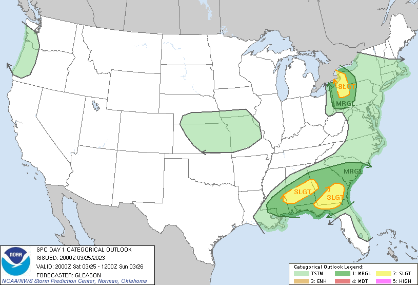
...THERE IS A SLIGHT RISK OF SEVERE THUNDERSTORMS ACROSS PARTS OF
WESTERN PENNSYLVANIA/NEW YORK...THE FLORIDA PANHANDLE INTO
SOUTHERN/CENTRAL GEORGIA...AND SOUTHERN/CENTRAL ALABAMA...
...SUMMARY...
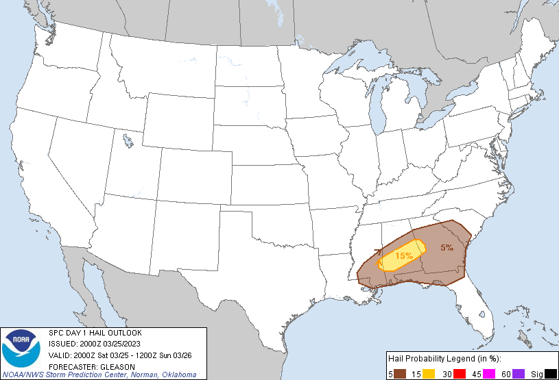
Isolated large hail and damaging winds will remain possible across
parts of the Florida Panhandle and southern/central Georgia this
afternoon and early evening. Another round of strong to severe
storms should occur early Sunday morning across portions of
southern/central Alabama. Occasional damaging winds remain possible
for the next hour or two across parts of western Pennsylvania and
New York.
...20Z Update...
Severe probabilities have been trimmed behind ongoing convection
that is rapidly progressing across northwest PA into western NY.
Occasional damaging winds will remain the primary severe threat with
this activity in the short term given the rather strong
low/mid-level southwesterly flow present. A cold/stable airmass is
present downstream of this convection into central PA and
south-central NY. This will likely limit appreciable severe risk
with eastward extent into these areas.
No changes have been made to the Slight Risk areas across the
Southeast. Widely spaced strong to severe thunderstorms continue in
and near Severe Thunderstorm Watch 79 across parts of the FL
Panhandle into southern/central GA. Moderate instability and strong
deep-layer shear should continue to support updraft organization
this afternoon, even though large-scale ascent/forcing remains
nebulous. Isolated hail and damaging winds should remain the primary
threats.
Robust convection still appears probable late tonight into early
Sunday morning from far eastern MS into southern/central AL and
perhaps far west-central GA, mainly after 26/06Z (1 AM CDT), and
continuing through the end of the Day 1 period. Large hail and
strong/gusty winds may occur with any supercell that can develop.
..Gleason.. 03/25/2023
.PREV DISCUSSION... /ISSUED 1123 AM CDT Sat Mar 25 2023/
...Synopsis...
Latest water-vapor imagery shows a compact, well-organized upper low
over the IL/IN region with a pronounced slot of dry air pushing
north ahead of the main vorticity maximum. At the surface, a 994 mb
surface low over southern lower MI is expected to gradually shift
east/northeast towards the Northeast over the next 12-24 hours in
tandem with the upper wave. Strong flow and ascent associated with
this feature is expected to overspread the upper OH river valley and
lower Great Lakes region, which will support the potential for
strong to severe thunderstorms through the late afternoon. Across
the Southeast, ongoing convection along a residual outflow boundary
is expected to persist into the mid/late afternoon and intensify to
severe limits. A late-night round of strong to severe thunderstorms
is expected during the early morning hours Sundays across parts of
MS/AL as the outflow boundary advances north as an effective warm
front tonight.
...Upper Ohio River Valley...
Considerable clearing is ongoing across parts of southern OH into
far southwest PA as the aforementioned dry slot advances northward.
This clearing has allowed temperatures to warm into the low to mid
60s ahead of an approaching cold front, which, as of 15:45 UTC, is
slightly warmer than most 12 UTC guidance. Consequently, low-level
lapse rates have already increased to around 7 C/km where warming
has been maximized. The combination of warming surface temperatures,
mid to upper 50s dewpoints, and cool temperatures aloft will support
increasing buoyancy through the mid-afternoon hours. Shallow
convection evident in visible imagery along the front across western
OH is expected to intensify as it moves into the destabilizing air
mass. Strong kinematic fields sampled by morning soundings and
recent VWP observations will be favorable for organized convection,
and the steep low-level lapse rates will allow for efficient mixing
of 50+ knot boundary layer winds to the surface. As a result,
damaging winds appear likely across eastern OH to western PA and
portions of western NY, though a few instances of severe hail and
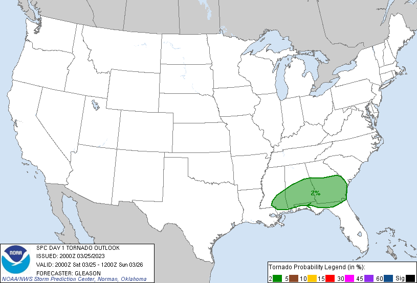
perhaps a brief tornado are plausible.
...Southeast Georgia and northern Florida...
GOES IR imagery has shown a slow intensification of ongoing
convection across portions of central/southern GA. Although this
region will become increasingly displaced from synoptic ascent and
stronger mid-level flow through the day, regional VWPs show
sufficient deep-layer shear for organized convection through peak
daytime heating. Furthermore, quality low-level moisture (sampled by
the 12 UTC TLH and JAX soundings) will migrate northeastward ahead
of the convection, allowing for MLCAPE values to increase to near
2000 J/kg. As a result, the recent intensification trend will likely
continue through the day and regionally augment the potential for
damaging winds and hail.
...Alabama...
The residual outflow boundary draped across the Southeast from prior
convection over the past 24 hours is expected to gradually lift to
the north through the day, eventually becoming draped from southeast
LA into southern MS and central AL by late tonight. A weak mid-level
perturbation is expected to move into the southern Plains/lower MS
River Valley during the 00-12 UTC period, which will help strengthen
southerly 850 mb flow and bolster isentropic ascent over the
boundary. Despite some nocturnal cooling, profiles are expected to
be weakly capped with MLCAPE values near 1000-2000 J/kg during the
overnight period. Elongated hodographs featuring around 50 knots of
effective shear should support organized cells, including splitting
supercells, that will pose a severe wind/hail risk (though storm
motions along the boundary may limit individual cell longevity and
promote upscale growth into clusters). Timing of this convection
remains uncertain with recent CAMs showing spread in the onset of
convective initiation, but the probability of CI prior to 12 UTC has
increased sufficiently to introduce higher risk probabilities.
CLICK TO GET WUUS01 PTSDY1 PRODUCT
NOTE: THE NEXT DAY 1 OUTLOOK IS SCHEDULED BY 0100Z