Columbus, OH...Milwaukee, WI...Kansas City, MO...Atlanta, GA...Grand Rapids, MI...
Probabilistic Damaging Wind Graphic
Probability of damaging thunderstorm winds or wind gusts of 50 knots or higher within 25 miles of a point. Hatched Area: 10% of greater probability of wind gusts 65 knots or greater within 25 miles of a point.
SPC AC 311630
Day 1 Convective Outlook
NWS Storm Prediction Center Norman OK
1130 AM CDT Fri Mar 31 2023
Valid 311630Z - 011200Z
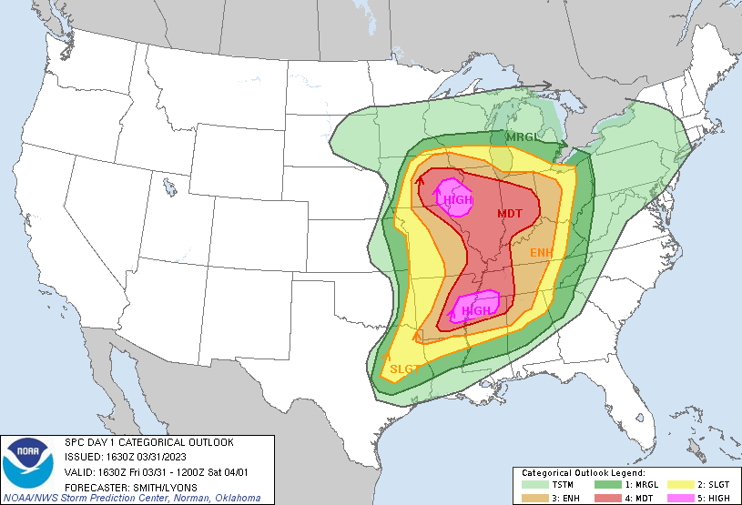
...THERE IS A HIGH RISK OF SEVERE THUNDERSTORMS FOR FAR SOUTHEAST
IOWA...WEST-CENTRAL ILLINOIS...FAR NORTHEAST MISSOURI AND IN PARTS
OF EASTERN ARKANSAS...NORTHERN MISSISSIPPI...AND SOUTHWESTERN
TENNESSEE...
...SUMMARY...
A severe weather outbreak appears increasingly likely, centered on
this afternoon and evening, across a large portion of the
Mississippi Valley. At least a few long-track, strong to potentially
violent tornadoes are probable, particularly over portions of the
Mid-Mississippi Valley to the Mid-South. Swaths of intense damaging
wind gusts along with very large hail are expected as well.
...Synopsis...
A dangerous severe weather outbreak is likely across a large
portion of the central states this afternoon into tonight.
Long-track, strong to potentially violent tornadoes are forecast
across a broad region of the MS Valley. The propensity of
model-supporting evidence and observational trends lends confidence
in the upgrade to bimodal High Risks for the mid MS Valley and lower
MS Valleys.
...Midwest and the Mid-MS to OH Valleys...
Morning water-vapor imagery shows a potent 500-mb speed max ejecting
east-northeast across the TX Panhandle/western OK to the south of a
mid-level low over northern NE. A 992-mb cyclone over western IA
will deepen through this afternoon as it matures into the Upper MS
Valley before occluding this evening. Visible-satellite
imagery/surface observations show a plume of increasingly rich
low-level moisture rapidly advecting northward into the lower MO
Valley with surface dewpoints rising into the lower 60s F. Strong
heating in combination with low-level moistening and cooling
mid-level temperatures, are expected to result in a relatively large
corridor featuring 1000-3000 J/kg MLCAPE across a moderate to
strongly unstable warm sector.
In agreement with prior forecast thinking, it seems the primary
severe evolution remains likely to evolve beginning around 19Z to
the southeast of the deep cyclone across central IA and broadening
in coverage through the late afternoon along the
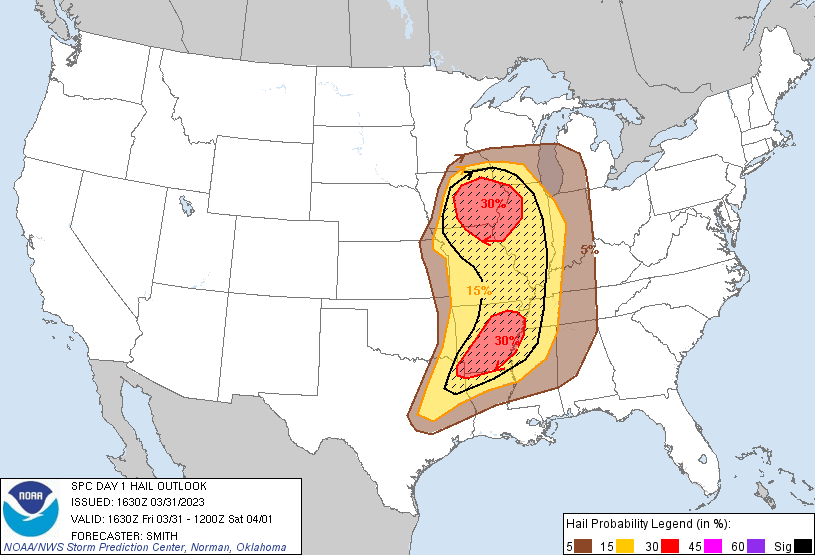
north/south-oriented cold front arcing southward into eastern MO.
Very steep mid-level lapse rates and an elongated mid to upper-level
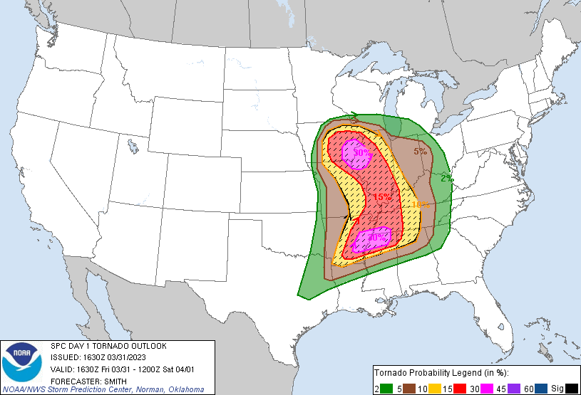
hodograph will initially support a broken band of supercells capable
of producing very large hail. The risk for tornadoes will likely
focus initially with supercells near and southeast of the surface
low. As this activity rapidly spreads into an increasingly
favorable low-level SRH environment in the eastern half of IA and
the MS Valley, several to numerous tornadoes are expected to form.
Forecast soundings within the High Risk show large 0-3-km MLCAPE
co-located with intense speed shear and large low-level and
elongated hodographs. Within this arcing band of quasi-discrete
supercells, several long-track strong to potentially violent
tornadoes are forecast for this afternoon into the evening.
Eventual upscale growth into an intense squall line with embedded
cellular elements is expected to evolve during the evening into
tonight across IL and rapidly sweep eastward across the OH
Valley/southern Great Lakes. Some risk for tornadoes will probably
spread east with the squall line coincident with a 70-kt 700-mb
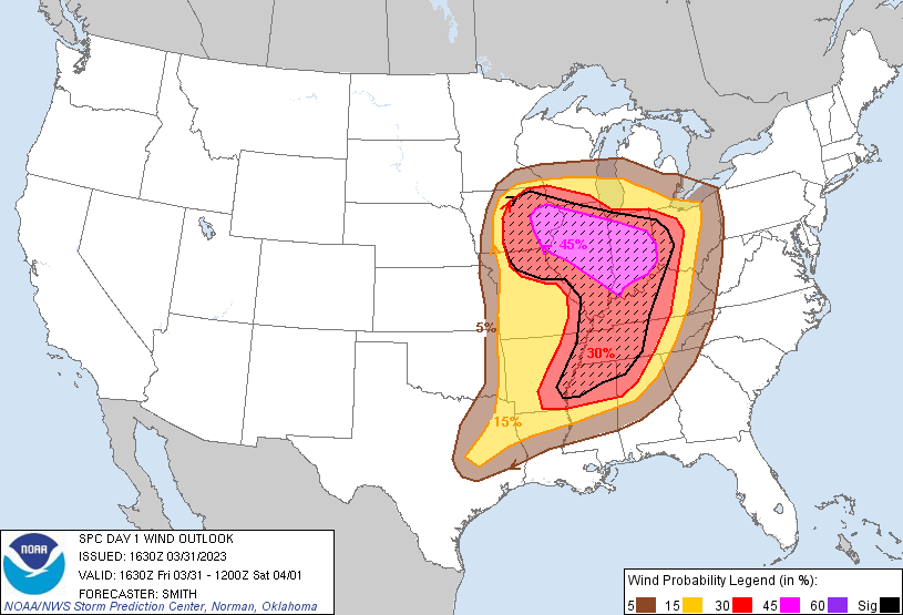
speed max overspreading the region. Severe gusts (60-90 mph) are
possible with surges/bowing structures and embedded cells within the
band of storms. Have expanded the Moderate Risk due to significant
wind gusts across eastern IL into IN. By late tonight, the evolving
QLCS will outpace weakening surface-based instability around the
central OH Valley. Extreme low-level wind fields could support a
waning wind/brief tornado threat approaching the central
Appalachians.
...Ark-La-Tex to the Lower MS/TN Valleys...
Multiple rounds of severe convection are expected to unfold,
intensifying this afternoon in AR and Ark-La-Tex, before continuing
east across the Lower MS into the TN Valleys through tonight.
Rapid airmass modification is currently underway across the lower MS
Valley with mid 60s deg F dewpoints surging north-northeast across
southern AR and towards the AR/TN/MS region. Initially, a capped
warm sector via an EML will act to limit storm development (isolated
early afternoon storms with mainly a hail risk). However, as
buoyancy increases (1500-2500 J/kg MLCAPE) and shear profiles
intensify, very favorable hodographs are forecast to develop by
mid-late afternoon across southern/eastern AR into adjacent
portions of MS/TN (effective SRH 300-600 m2/s2). Scattered
thunderstorms will likely develop by late afternoon with these
rapidly evolving into supercells. Strong to potentially violent
tornadoes are forecast with a few long-tracked supercells.
Upscale growth into a QLCS with embedded supercells appears probable
during the late evening and overnight as frontal convergence
strengthens. Tornadoes and significant damaging wind swaths will
remain possible well into the night across at least into the TN
Valley, until warm-sector low-level flow becomes more veered towards
the end of the period.
..Smith/Lyons.. 03/31/2023
CLICK TO GET WUUS01 PTSDY1 PRODUCT
NOTE: THE NEXT DAY 1 OUTLOOK IS SCHEDULED BY 2000Z