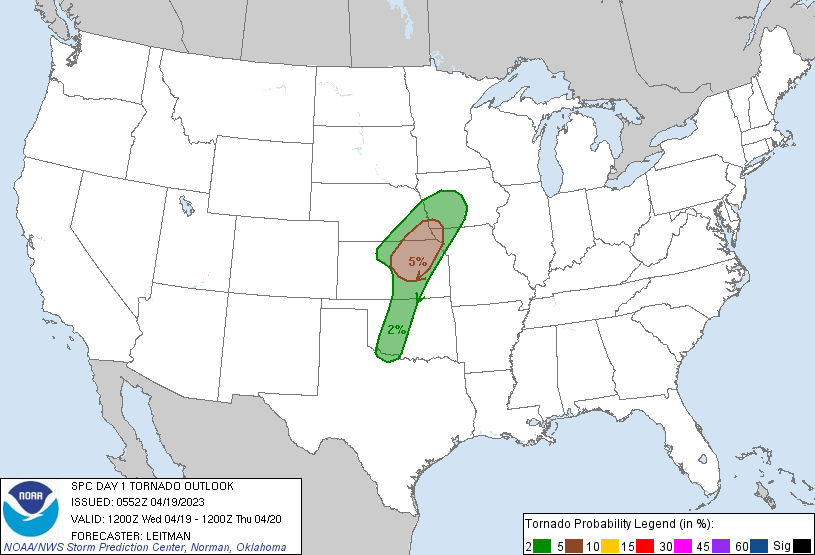
Oklahoma City, OK...Omaha, NE...Wichita, KS...Lincoln, NE...Des Moines, IA...
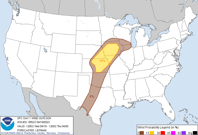
Probabilistic Damaging Wind Graphic
Probability of damaging thunderstorm winds or wind gusts of 50 knots or higher within 25 miles of a point. Hatched Area: 10% of greater probability of wind gusts 65 knots or greater within 25 miles of a point.
Day 1 Wind Risk
Area (sq. mi.)
Area Pop.
Some Larger Population Centers in Risk Area
15 %
93,992
6,539,042
Kansas City, MO...Omaha, NE...Wichita, KS...Lincoln, NE...Des Moines, IA...
5 %
163,042
10,951,709
Oklahoma City, OK...Tulsa, OK...Madison, WI...Aurora, IL...Rockford, IL...
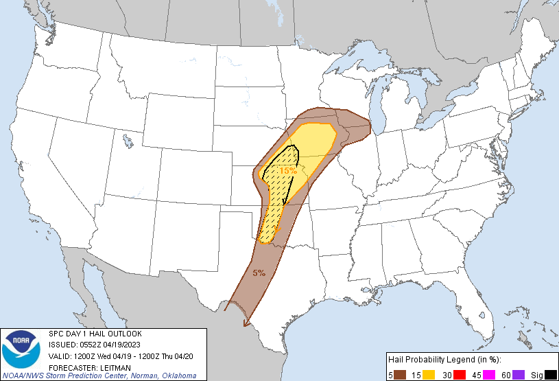
Probabilistic Large Hail Graphic
Probability of hail 1" or larger within 25 miles of a point. Hatched Area: 10% or greater probability of hail 2" or larger within 25 miles of a point.
Kansas City, MO...Omaha, NE...Wichita, KS...Lincoln, NE...Des Moines, IA...
5 %
146,552
10,012,006
Oklahoma City, OK...Tulsa, OK...Madison, WI...Aurora, IL...Rockford, IL...
SPC AC 190552
Day 1 Convective Outlook
NWS Storm Prediction Center Norman OK
1252 AM CDT Wed Apr 19 2023
Valid 191200Z - 201200Z
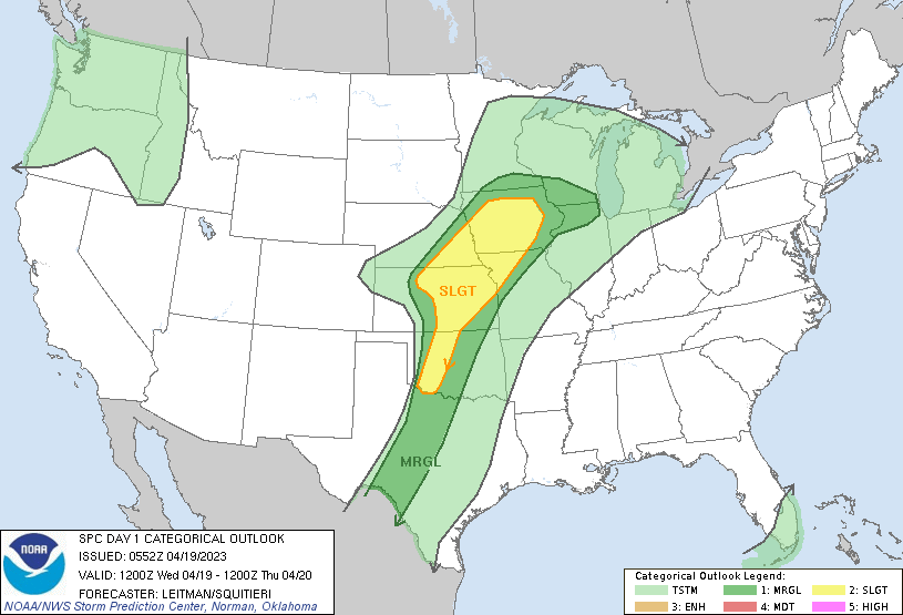
...THERE IS A SLIGHT RISK OF SEVERE THUNDERSTORMS ACROSS WESTERN
OKLAHOMA...CENTRAL/EASTERN KANSAS...SOUTHEAST NEBRASKA...NORTHWEST
MISSOURI...AND PARTS OF IOWA...
...SUMMARY...
Severe thunderstorms with the potential for very large hail, a risk
for a few of tornadoes, and severe gusts will be possible late this
afternoon into tonight across parts of the central states.
...Central/Southern Plains to the Upper Midwest Vicinity...
A closed upper low is forecast to meander over eastern MT to
southern SK today/tonight. An upper shortwave trough attendant to
the low will pivot across the central/southern Rockies and into the
Plains during the afternoon and into the overnight period. As this
occurs, increasing southwesterly deep-layer flow will overspread the
Plains, with a 55-70 kt 500 mb jet developing over KS/NE by 00-03z.
An initial surface low is forecast near the southeast NE/northeast
KS border this morning, before occluding by midday. However, as the
mid/upper trough begins to eject over the Rockies and into the
Plains, stronger cyclogenesis will result in a deepening low over
western KS by late afternoon. This low will lift northeast during
the evening, with a sharpening dryline extending southward across
central KS into western OK/TX. Overnight, a cold front will sweep
southeast across the central/southern Plains.
A relative max in severe thunderstorm potential is expected in the
vicinity of the triple point from central KS into southeast NE where
the best combination of favorable shear, stronger forcing and
adequate boundary-layer moisture will reside. Forecast guidance
still indicates some degree of spread with regard to northward
moisture return, but dewpoints to at least the low 60s F seem likely
across central/eastern KS, northeast into the mid-MO Valley
vicinity. Very steep mid-level lapse rates atop modest
boundary-layer moisture will promote strong destabilization, and
convective initiation appears likely near the triple point from
north-central/northeast KS into southeast NE by 00z. Initial
supercells capable of very large hail are possible. A few tornadoes
also will be possible near the surface low and along the warm front
where low-level vorticity and shear will be enhanced. As a low-level
jet increases during the evening and the cold front surges
southeastward across the central Plains, some upscale development
into a line is possible with an accompanying increase in damaging
wind potential. This activity should spread northeast into
IA/southern MN and WI/northern IL overnight with a continued
wind/hail threat.
A more conditional threat is expected with southward extent along
the dryline into parts of western/central OK, and perhaps as far
south as western north TX. A sharp dryline will reside across
western OK with surface dewpoints in the mid 60s possible.
Large-scale ascent will be weaker with southward extent. However,
strong heating along the dryline and favorable low-level convergence
is likely to aid in attempts to overcome moderate capping. If
capping is overcome, isolated discrete supercells will have a narrow
window of opportunity to develop across parts of western/central OK.
While mixing/entrainment of drier air is expected (and may delay
convective initiation until near/after 00z), ECAPE still indicates
MLCAPE near/above 2500 J/kg. Furthermore, enlarged low-level
hodographs becoming elongated above 3 km are forecast. This
parameter space will be more than sufficient to support potentially
very large hail (3+ inch diameter). A tornado or two, along with
damaging gusts also will be possible with any supercell that may
develop. If cells can become established, severe potential will be
limited in time/space given expected late initiation timing and
increasing CINH with eastward extent after 00z.
...TX dryline...
Model guidance currently indicates a paucity of convective potential
along the dryline over parts of north-central TX southward to the
Edwards Plateau. A conditionally very unstable boundary layer and
deep-layer shear will support supercell potential. Any storm that
manages to develop will likely pose a large-hail threat for at least
an hour or two before this risk diminishes by mid evening.
..Leitman/Squitieri.. 04/19/2023
CLICK TO GET WUUS01 PTSDY1 PRODUCT
NOTE: THE NEXT DAY 1 OUTLOOK IS SCHEDULED BY 1300Z