Probability of damaging thunderstorm winds or wind gusts of 50 knots or higher within 25 miles of a point. Hatched Area: 10% of greater probability of wind gusts 65 knots or greater within 25 miles of a point.
New York, NY...Jacksonville, FL...Newark, NJ...Jersey City, NJ...Yonkers, NY...
SPC AC 141626
Day 1 Convective Outlook
NWS Storm Prediction Center Norman OK
1126 AM CDT Wed Jun 14 2023
Valid 141630Z - 151200Z
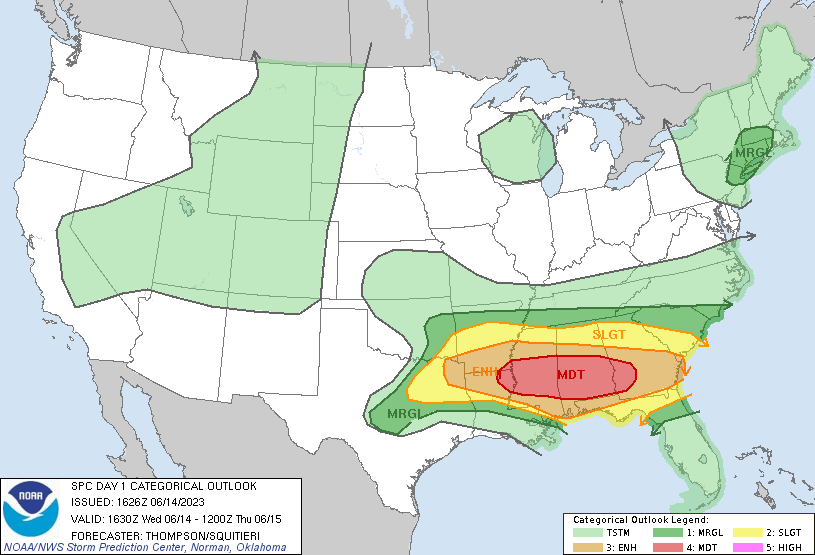
...THERE IS A MODERATE RISK OF SEVERE THUNDERSTORMS THIS AFTERNOON
INTO TONIGHT FROM THE ARKLAMISS ACROSS AL INTO SOUTHWEST GA...
...SUMMARY...
Significant severe thunderstorms capable of producing all severe
hazards, including very large hail, swaths of intense wind
gusts/damage, and tornadoes, are expected from the ArkLaTex into the
Southeast this afternoon into tonight.
...ArkLaTex to GA through tonight...
The unusually strong flow pattern continues from the southern Plains
eastward to the Southeast, with 50+ kt midlevel flow across the
corridor, coincident with steep midlevel lapse rates and strong
buoyancy. Embedded speed maxima will move generally eastward
through this corridor, around the southern periphery of the midlevel
closed low over the lower Great Lakes. The primary severe threat
will continue through the afternoon and into tonight from the
ArkLaTex across MS/AL into southern GA.
Multiple clusters of severe storms are ongoing, including both
supercells and line segments. The cluster in northern MS will
likely persist through the afternoon while moving east-southeastward
across central AL, where additional supercell development is
expected within the warm sector ahead of the cluster. The
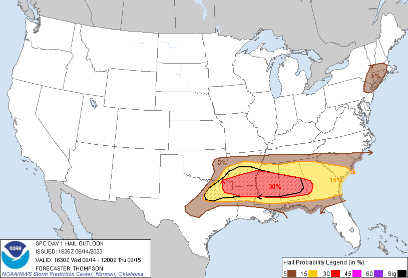
environment of large buoyancy (MLCAPE 3000-4000 K/kg) and effective
bulk shear in excess of 60 kt is quite unusual for mid June into the
I-20 corridor, and this will support an unusually high threat for
severe storms (including significant severe events). Supercells
will be capable of producing isolated very large hail to near 3
inches in diameter with the supercells forming in northeast TX, and
with supercells farther east into AL. A complex storm evolution is
expected from MS across AL into GA along the buoyancy gradient, as
the ongoing clusters and new storms interact and potentially support
upscale growth into larger clusters.
Swaths of wind damage, some up to 80 mph, can be expected with the
MS/AL clusters this afternoon and into GA along the residual outflow
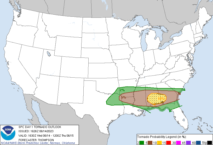
boundary. This boundary will locally enhance low-level shear, with
the potential for a few tornadoes (a couple of which could be
strong), from southwest GA into southeast/central AL with both the
isolated supercells and with embedded circulations in any larger
clusters. Another cluster could evolve from the northeast TX
supercells, and this convection will have a corridor of strong
instability to support its maintenance across northern LA into
central MS and eventually AL later this afternoon into early
tonight. The initial supercells could produce very large hail,
while upscale growth will favor swaths of damaging winds (some
significant), as well as a few tornadoes.
...Central TX this afternoon/evening...
Strong-extreme buoyancy is expected again across central TX, but
forcing for ascent will be weak. If sufficient heating/mixing can
occur, an isolated storm may form this afternoon along the surface
front into central TX. The environment conditionally favors
splitting supercells with very large hail, though storm
formation/coverage is uncertain.
...Northern Mid-Atlantic/southern New England this afternoon...
Pockets of surface heating will drive weak buoyancy to the east of
the low across southern New England, where isolated strong-severe
storms may occur (see MD #1037 for additional information).
..Thompson/Squitieri.. 06/14/2023
CLICK TO GET WUUS01 PTSDY1 PRODUCT
NOTE: THE NEXT DAY 1 OUTLOOK IS SCHEDULED BY 2000Z