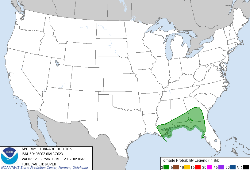
Probability of a tornado within 25 miles of a point. Hatched Area: 10% or greater probability of EF2 - EF5 tornadoes within 25 miles of a point.
Day 1 Tornado Risk
Area (sq. mi.)
Area Pop.
Some Larger Population Centers in Risk Area
2 %
87,216
7,900,610
New Orleans, LA...Baton Rouge, LA...Mobile, AL...Columbus, GA...Tallahassee, FL...
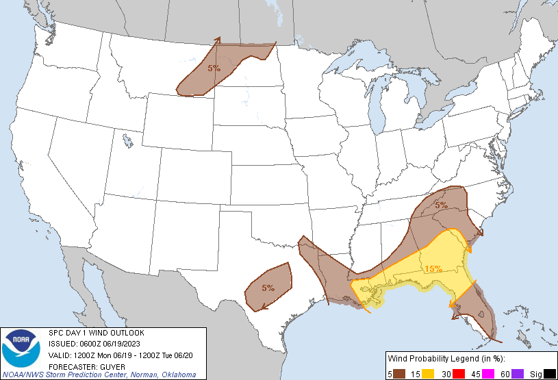
Probabilistic Damaging Wind Graphic
Probability of damaging thunderstorm winds or wind gusts of 50 knots or higher within 25 miles of a point. Hatched Area: 10% of greater probability of wind gusts 65 knots or greater within 25 miles of a point.
SPC AC 190600
Day 1 Convective Outlook
NWS Storm Prediction Center Norman OK
0100 AM CDT Mon Jun 19 2023
Valid 191200Z - 201200Z
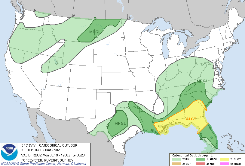
...THERE IS A SLIGHT RISK OF SEVERE THUNDERSTORMS ACROSS THE MIDDLE
GULF COAST/SOUTHEAST STATES...
...SUMMARY...
Severe thunderstorms capable of producing damaging winds are
possible across parts of the middle Gulf Coast states and Southeast
today. Additional isolated strong to severe thunderstorms are also
possible into parts of the Carolinas, central/north Texas, and the
northern Plains.
...Middle Gulf Coast/Southeast States...
Clusters of strong/potentially severe storms are likely to be
ongoing this morning from southern Mississippi into southern
Alabama/southern Georgia and north Florida. A diurnal
reintensification of these storms should occur today on the southern
fringes of the lingering early day storms/cloud cover.
Severe/damaging gusts will be the main hazard associated with this
activity given its mainly linear/cluster nature as low-level lapse
rates steepen.
Other storms should develop later in the afternoon along the
westward-extending portion of the front near the middle Gulf Coast,
with these storms capable of large hail and damaging winds. This is
attributable to ample instability coincident with a belt of
moderately strong northwesterly winds aloft.
As waves of large-scale ascent pivot around the upper low,
additional bands of thunderstorms are expected further north and
east across eastern Tennessee into the Carolinas. Instability will
be weaker with northward extent. However, steepening low-level lapse
rates and a high PW environment may support sporadic strong/damaging
wind gusts. Additional clusters of strong storms may develop along
sea-breeze boundaries across the Florida Peninsula. Water-loaded
downdrafts may pose a risk for strong gusts here as well, along with
occasional hail.
...Central/North Texas...
Steady height rises are expected as the upper ridge builds over the
Plains through tonight, with a related warming of mid-level
temperatures and uncertainty regarding the likelihood/extent of
late-day deep convective potential. Regardless, a thermally aided
surface low should deepen across the Low Rolling Plains, with robust
post-dryline mixing (surface temperatures 100+ F) and at least
modest near-dryline/triple point convergence suggesting some
potential for isolated semi-sustained convection late this
afternoon.
Any convection that develops and can sustain will have the potential
to become a supercell in the presence of seasonally strong (40-55
kt) mid/upper-level northwest flow. Given the presence of steep
mid-level lapse rates and moderate to strong instability, isolated
large hail may occur with any supercell. Severe-caliber wind gusts
are also plausible, as the boundary layer should be very well mixed,
with steepened low-level lapse rates due to the robust diurnal
heating. Any severe risk should diminish by around, or shortly
after, sunset as the boundary layer slowly cools.
...ArkLaTex/Louisiana...
On the edge of strong capping aloft, storms are expected to develop
tonight near the front across the region, with some potential that
these storms will be strong to severe. Very steep mid-level lapse
rates and ample elevated buoyancy in the presence of strong shear
through the cloud-bearing layer could support some storms capable of
large hail.
...Eastern Montana and western/northern North Dakota...
The region will be influenced by the eastern periphery of a
prominent upper trough centered over the Pacific Northwest and its
preceding polar jet. This jet will interface with modest low-level
moisture on the cool side of a roughly southwest/northeast-oriented
front across the region, where forcing for ascent will be maximized.
Widely scattered storms are expected to initially develop this
afternoon across southeast Montana and northeast Wyoming near the
Bighorn Mountains. This convection should persist/expand
northeastward across eastern Montana and parts of western/north
North Dakota through evening. Even while overall buoyancy will be
modest, deep-layer shear should be strong enough to support some
supercells and sustained multicells with an attendant threat for
large hail and severe-caliber wind gusts.
..Guyer/Flournoy.. 06/19/2023
CLICK TO GET WUUS01 PTSDY1 PRODUCT
NOTE: THE NEXT DAY 1 OUTLOOK IS SCHEDULED BY 1300Z