Denver, CO...Colorado Springs, CO...Aurora, CO...Lakewood, CO...Fort Collins, CO...
Probabilistic Damaging Wind Graphic
Probability of damaging thunderstorm winds or wind gusts of 50 knots or higher within 25 miles of a point. Hatched Area: 10% of greater probability of wind gusts 65 knots or greater within 25 miles of a point.
Day 1 Wind Risk
Area (sq. mi.)
Area Pop.
Some Larger Population Centers in Risk Area
SIG SEVERE
81,819
3,922,799
Fort Worth, TX...Waco, TX...Abilene, TX...Killeen, TX...Wichita Falls, TX...
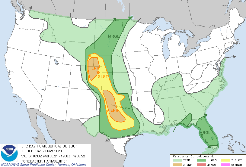
SPC AC 211623
Day 1 Convective Outlook
NWS Storm Prediction Center Norman OK
1123 AM CDT Wed Jun 21 2023
Valid 211630Z - 221200Z
...THERE IS AN ENHANCED RISK OF SEVERE THUNDERSTORMS THIS AFTERNOON
AND EVENING OVER PARTS OF EASTERN COLORADO...SOUTHEAST WYOMING...AND
THE NEBRASKA PANHANDLE...AND FROM THE EASTERN TEXAS PANHANDLE AND
WESTERN OKLAHOMA INTO CENTRAL TEXAS....
...SUMMARY...
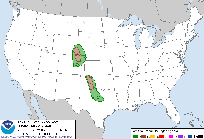
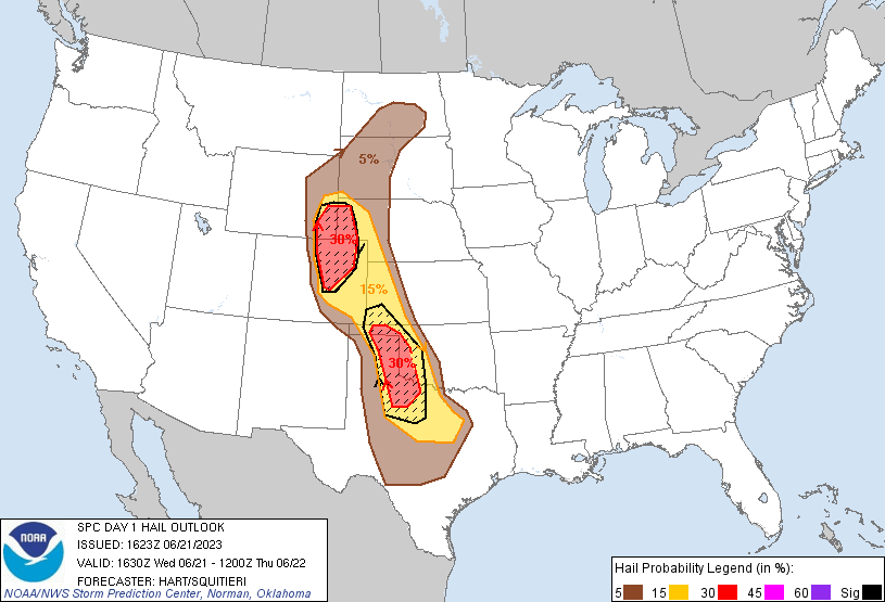
Intense severe thunderstorms are expected this afternoon and evening
over parts of the central and southern Plains, where severe gusts,
very large hail, and a few tornadoes are possible.
...TX/OK...
Morning water vapor imagery shows a large upper trough over the
western states, with moderately strong southwesterly mid-level winds
across much of the central and southern High Plains. At the
surface, an extremely moist and potentially unstable air mass
(dewpoints in the mid 70s) is present from the eastern TX Panhandle
eastward into western OK, and extending southeastward into central
TX. Full heating will lead to afternoon MLCAPE values of 5000-6000
J/kg and minimal cap. Large scale forcing is weak, but circulations
along the surface dryline will lead to rapidly thunderstorm
development from extreme southwest KS into the eastern TX Panhandle.
These storms are likely to be supercells capable of very large hail
and a few tornadoes.
These storms are likely to slowly congeal into one or more bowing
complexes by mid evening, tracking southeastward into northwest and
central TX. Several morning CAM solutions suggest the potential for
a corridor of significant wind damage if this scenario unfolds.
...Eastern CO/Southeast WY...
An extremely moist and unstable low-level air mass is streaming into
the central High Plains, with dewpoints in the 70s being transported
westward into the higher elevations of the eastern CO/southeast WY
plains. Strong daytime heating and steep mid-level lapse rates will
yield afternoon MLCAPE values over 3000 J/kg. All morning CAM
solutions agree on the development of scattered thunderstorms by
mid-afternoon along the front range and foothills, as well as the
DCVZ along the Palmer Ridge. A combination of backed low-level
winds and 30+ knots of southwesterly flow aloft will promote
supercell structures capable of very large hail and a few tornadoes.
The threat of severe storms may persist much of the evening,
building southward along the Front Range into southeast CO.
..Hart/Squitieri.. 06/21/2023
CLICK TO GET WUUS01 PTSDY1 PRODUCT
NOTE: THE NEXT DAY 1 OUTLOOK IS SCHEDULED BY 2000Z