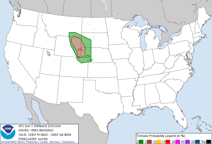
Greeley, CO...Rapid City, SD...Cheyenne, WY...Casper, WY...Sheridan, WY...
Probabilistic Damaging Wind Graphic
Probability of damaging thunderstorm winds or wind gusts of 50 knots or higher within 25 miles of a point. Hatched Area: 10% of greater probability of wind gusts 65 knots or greater within 25 miles of a point.
Day 1 Wind Risk
Area (sq. mi.)
Area Pop.
Some Larger Population Centers in Risk Area
SIG SEVERE
107,674
898,819
Lubbock, TX...Rapid City, SD...Norfolk, NE...Plainview, TX...Scottsbluff, NE...
30 %
71,738
425,940
Rapid City, SD...North Platte, NE...Scottsbluff, NE...Pierre, SD...Spearfish, SD...
15 %
160,306
6,428,454
Plano, TX...Garland, TX...Lubbock, TX...Irving, TX...Amarillo, TX...
5 %
347,329
16,869,641
Philadelphia, PA...Dallas, TX...Fort Worth, TX...Oklahoma City, OK...Omaha, NE...
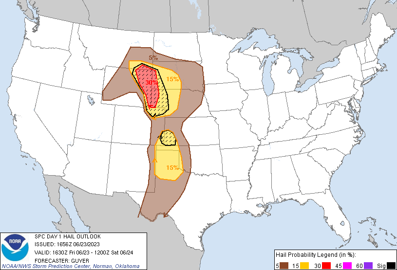
Probabilistic Large Hail Graphic
Probability of hail 1" or larger within 25 miles of a point. Hatched Area: 10% or greater probability of hail 2" or larger within 25 miles of a point.
Day 1 Hail Risk
Area (sq. mi.)
Area Pop.
Some Larger Population Centers in Risk Area
SIG SEVERE
72,513
528,050
Rapid City, SD...Garden City, KS...Gillette, WY...Scottsbluff, NE...Sterling, CO...
Lubbock, TX...Amarillo, TX...Rapid City, SD...Cheyenne, WY...Garden City, KS...
5 %
284,719
2,799,783
Sioux Falls, SD...Abilene, TX...Midland, TX...Odessa, TX...San Angelo, TX...
   SPC AC 231656

   Day 1 Convective Outlook
   NWS Storm Prediction Center Norman OK
   1156 AM CDT Fri Jun 23 2023

   Valid 231630Z - 241200Z

   ...THERE IS AN ENHANCED RISK OF SEVERE THUNDERSTORMS ACROSS THE
   NORTH-CENTRAL HIGH PLAINS...

   ...THERE IS A SLIGHT RISK OF SEVERE THUNDERSTORMS ACROSS THE
   SOUTHERN PLAINS...

   ...SUMMARY...
   Scattered severe thunderstorms, capable of producing large hail and
   strong/damaging wind gusts and a tornado or two, are expected across
   the North-central High Plains, with other severe storms across the
   southern Plains today and tonight.

   ...North-central Plains...
   No changes for this region aside from Marginal-related spatial
   adjustments across Wyoming. The most concentrated, well-organized
   severe threat still appears to be over parts of the High Plains from
   southeastern Montana to western Nebraska this afternoon and evening.
   Scattered thunderstorms should evolve upscale from initial multicell
   and supercell development near the Bighorn and Laramie Ranges, with
   an early multimodal threat transitioning toward severe wind (locally
   65+ kt gusts possible) with time this evening and overnight.

   A relatively narrow corridor of favorable airmass heating,
   warm-advection-related recovery, and upslope flow into higher
   terrain will support afternoon/evening severe potential. Activity
   should develop over and near the Wyoming ranges this afternoon as
   strengthening large-scale ascent and deep-layer shear spread over
   the region ahead of the ejecting shortwave trough, conterminous with
   favorably, diabatically minimized MLCINH. Initial mixed-mode
   convection will offer all severe hazards, with tornadoes and
   significant hail being a threat from any sustained supercell(s).

   Steep low/middle-level lapse rates and favorable boundary-layer
   moisture will contribute to peak/preconvective MLCAPE ranging from
   near 3000 J/kg over the northeastern Colorado/southwestern Nebraska
   to 1000-2000 J/kg in a small part of northeastern Wyoming and
   southeastern Montana. Lengthening and well-curved hodographs are
   forecast to develop as low-level cyclogenesis proceeds, in support
   of the hail/tornado threat. One or two MCSs should evolve this
   evening, accessing theta-e advection and moisture transport related
   to a 40-45 kt LLJ, with aggregation of cold pools rendering an
   increasingly widespread threat for damaging and severe gusts. The
   severe risk should continue eastward across Nebraska/South Dakota
   much of the night.

   ...Southern Plains including West/North Texas and Oklahoma...
   A cluster of strong/severe storms is ongoing across west-central
   Oklahoma at late morning. These storms continue to exhibit
   upscale-growing trends aside from a morning history of isolated
   severe-caliber wind gusts. The potential for wind damage and
   isolated hail may persist east-southeastward across southern/central
   Oklahoma and nearby north Texas this afternoon.

   Otherwise, farther west, widely scattered thunderstorms are expected
   to redevelop by mid/late afternoon near the dryline/lee trough
   across far west/northwest Texas including the Texas South Plains.
   These initially high-based storms will progress eastward, with some
   of these storms potentially interacting with the outflow-reinforced
   baroclinic zone via the early day storms. Storms will gradually
   encounter greater low-level moisture as they move eastward, with
   surface dewpoints into the 60s and lower 70s F, with 2500-3500 J/kg
   MLCAPE near and east of the Caprock.

   Though near-surface flow will be modest, strong veering with height
   will enable enough deep-layer shear (effective values around 35-40
   kt) for a blend of early multicell and supercell modes, offering
   both large hail and severe-caliber wind gusts. A gradual coalescence
   of cold pools from multiple storms is probable, with a severe risk
   probably continuing eastward this evening into the overnight across
   north Texas and possibly southern Oklahoma.

   ...Eastern Colorado/western Kansas...
   Severe risk adjustments have been made across the region given
   trends in short-term observations/guidance. Concern exists for a
   viable potential for intense storm development, even if somewhat
   isolated, by mid/late afternoon, within a supercell-favorable
   environment including steep lapse rates, strong buoyancy and 40+ kt
   effective shear.

   ...Mid-Atlantic States/Delmarva...
   Ahead of the upper low centered over Ohio/Lower Great Lakes, a moist
   environment with moderately enhanced low-level southerly winds may
   support a few stronger/locally severe storms this afternoon across
   the region.

   ..Guyer/Gleason.. 06/23/2023

   CLICK TO GET WUUS01 PTSDY1 PRODUCT

   NOTE: THE NEXT DAY 1 OUTLOOK IS SCHEDULED BY 2000Z