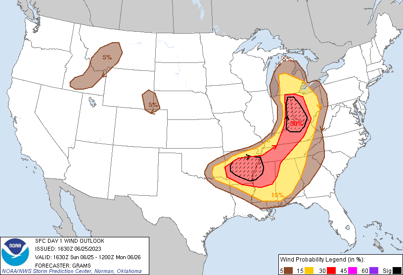
Probability of damaging thunderstorm winds or wind gusts of 50 knots or higher within 25 miles of a point. Hatched Area: 10% of greater probability of wind gusts 65 knots or greater within 25 miles of a point.
SPC AC 251630
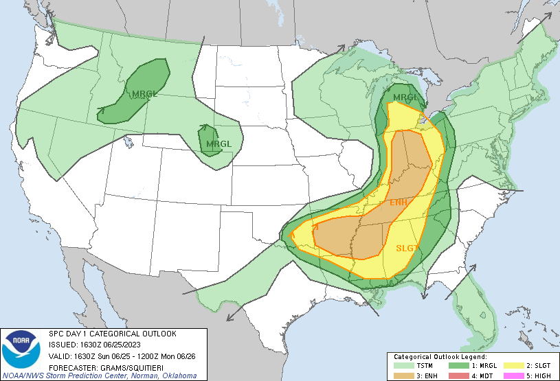
Day 1 Convective Outlook
NWS Storm Prediction Center Norman OK
1130 AM CDT Sun Jun 25 2023
Valid 251630Z - 261200Z
...THERE IS AN ENHANCED RISK OF SEVERE THUNDERSTORMS PARTS OF THE
MIDWEST/CENTRAL OH VALLEY TO THE MID/DEEP SOUTH...
...SUMMARY...
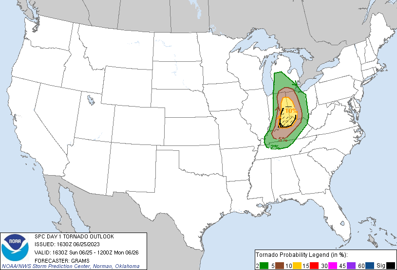
Scattered to numerous severe storms are expected through tonight
across a broad portion of the Midwest/Ohio Valley into the Mid and
Deep South. The greatest threat for tornadoes, at least a couple of
which could be strong, appears to be in the eastern Indiana, western
Ohio, and northern Kentucky vicinity during the late afternoon to
early evening.
...Central Great Lakes/OH Valley to the Mid/Deep South...
Shortwave trough over the Upper MS Valley will shift east into Lower
MI tonight. Attendant surface cyclone will similarly track east from
west-central WI into west-central Lower MI. Arcing cold front will
have greater eastward advancement across parts of the Midwest, with
trailing portion drifting south-southeast across the Mid-South. A
broad swath of severe potential remains evident ahead of this front,
likely yielding scattered areas of severe storms and embedded
mesoscale corridors of more numerous reports.
Ongoing convection persists across southeast KY into middle/eastern
TN and will probably continue along the gradually eastward-shifting,
north/south-oriented MLCAPE gradient. An isolated damaging wind
threat should exist downstream across the southern Appalachians. A
scattered wind/hail threat may emerge within multicell clusters that
can regenerate westward later this afternoon over the TN Valley and
persist into this evening.
Potential for more numerous severe events appears to be focused
within two bimodal corridors along/ahead of the front. The first is
in the vicinity of eastern IN/western OH/northern KY border.
Scattered thunderstorms will increase during the next few hours in
the Lake MI vicinity arcing south across IN and then southwest
across the Lower OH Valley. In the wake of the morning convection in
KY, trailing outflow appears to have finally stalled across western
KY and far southwest IN. How far to the northeast recovery can occur
in its wake is uncertain, but it is plausible that it may be able to
reach the IN/OH/KY border area by late afternoon/early evening. With
a plume of mid 70s surface dew points to the west of this outflow,
large buoyancy with MLCAPE of 3000-3500 J/kg will become common.
Despite gradual weakening of the strong mid-level jetlet attendant
to the shortwave trough, the leading edge of 50+ kt 500-mb
westerlies should overlay the Lower OH Valley portion of the front.
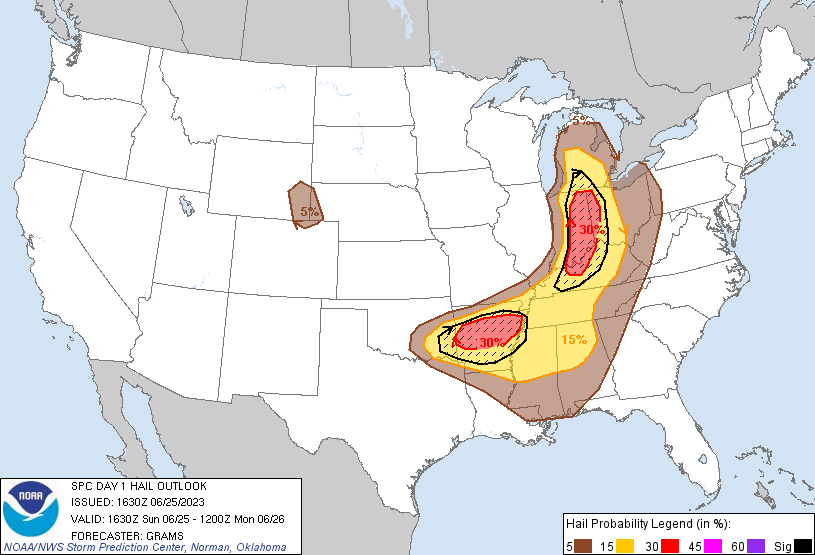
This setup will likely yield the best CAPE/shear/SRH parameter space
near the IN/OH/KY border area where a few intense supercells are
expected, capable of producing strong tornadoes and destructive
hail/wind. Quicker upscale growth into clusters/QLCS is expected
with northern extent where deep-layer wind profiles will be less
favorable for maintaining discrete supercell structures. This
activity should eventually outpace/become pinched off from the large
buoyancy plume emanating from the Lower OH Valley.
A second area of potentially destructive hail and wind should
emanate along the AR portion of the front. The 12Z LZK sounding had
a very favorable thermodynamic profile with a mean-mixing ratio of
18 g/kg and mid-level lapse rates of 8-8.5 C/km. With 74-77 F
surface dew points common to the south of the front, very large
buoyancy of 3500-4000 J/kg will be prevalent by late afternoon.
Scattered thunderstorms will develop across northern AR and quickly
become supercells within the gradient of mid/upper
west-northwesterly flow. This type of orientation semi-parallel to
the front should support upscale growth during the evening. Most
morning CAMs are consistent in suggesting an MCS will evolve
southeast across the Lower MS Valley with an enhanced threat for
damaging winds.
..Grams/Squitieri.. 06/25/2023
CLICK TO GET WUUS01 PTSDY1 PRODUCT
NOTE: THE NEXT DAY 1 OUTLOOK IS SCHEDULED BY 2000Z