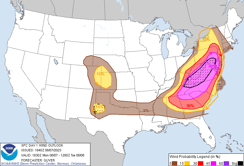
Probability of damaging thunderstorm winds or wind gusts of 50 knots or higher within 25 miles of a point. Hatched Area: 10% of greater probability of wind gusts 65 knots or greater within 25 miles of a point.
Philadelphia, PA...Memphis, TN...Charlotte, NC...Denver, CO...Oklahoma City, OK...
SPC AC 071640
Day 1 Convective Outlook
NWS Storm Prediction Center Norman OK
1140 AM CDT Mon Aug 07 2023
Valid 071630Z - 081200Z
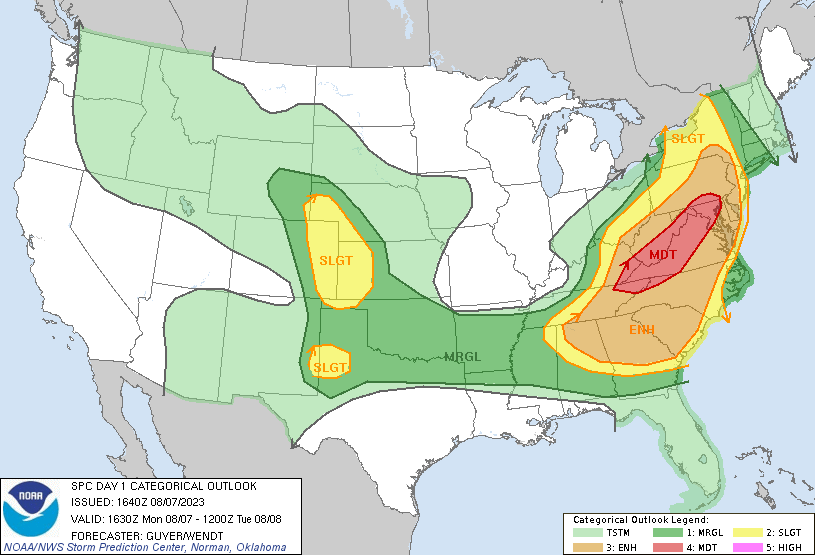
...THERE IS A MODERATE RISK OF SEVERE THUNDERSTORMS ACROSS FAR
EASTERN KY/NORTHEAST TN/NORTHWEST NC...WESTERN AND NORTHERN
VA...SOUTHERN AND EASTERN WV...CENTRAL MD...AND SOUTH-CENTRAL PA...
...THERE IS A SLIGHT RISK OF SEVERE THUNDERSTORMS ACROSS THE CENTRAL
AND SOUTHERN HIGH PLAINS...
...SUMMARY...
A severe weather outbreak is expected across parts of the eastern
U.S. today with widespread and locally destructive damaging winds
and tornadoes as the greatest threats, especially across the
southern/central Appalachians and Mid-Atlantic States.
...Southeast to the Upper Ohio Valley to the Mid-Atlantic States...
Owing to a very moist/unstable air mass and very strong winds aloft
for August, a widespread severe-weather risk is already unfolding at
late morning/midday across a broad region, initially west of the
Appalachians spine. Refer to ongoing Watches and Mesoscale
Discussions for the latest regional details.
A shortwave trough over the Lower Ohio Valley will continue to
advance toward the northern Appalachians by evening. A pair of
500-mb speed maxima from 55-65 kts are expected to be centered by
late afternoon across eastern KY/TN and southern WV into western
VA/NC, and separately over the Mid-South. Peak flow within an
expansive 700-mb jet should be centered between the 500-mb maxima
across the TN Valley. A plume of large potential buoyancy supported
by high PW and steep mid-level lapse rates, and centered over the
Mid-South/TN Valley will expand east-northeast towards the
central/southern Appalachians with an expansive swath of MLCAPE from
2000-3500 J/kg expected by peak heating.
Ongoing storms across eastern portions of TN/KY and WV/southern OH
will progress into an increasingly favorable thermodynamic and
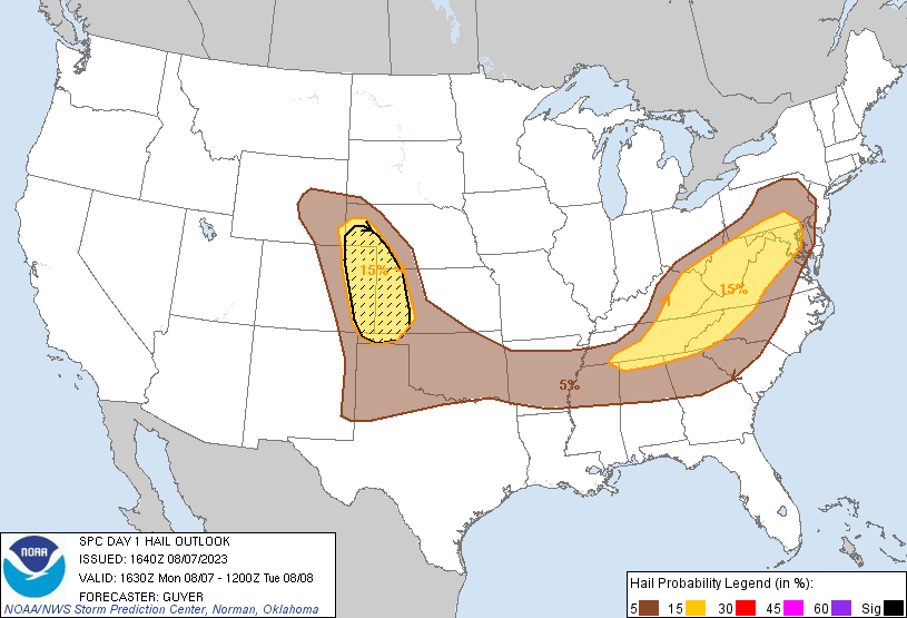
kinematic environment downstream, yielding many supercells capable
of producing large hail, damaging winds, and tornadoes. Upscale
growth into several linear clusters with embedded supercells is
anticipated this afternoon as convective coverage becomes widespread
from PA/MD south-southwest across the southern Appalachian states.
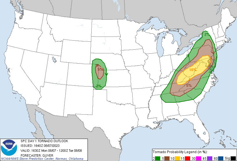
Forecast soundings suggest the greatest tornado threat will probably
exist across eastern KY/TN northeast across southern/eastern WV,
western VA, central MD and into southeast PA. Given the supercell
wind profiles, significant severe wind gusts will also be possible
on a localized basis.
Across the Southeast, aided by a separate mid-level speed max,
linear clusters of storms will continue to develop and spread
generally eastward across parts of the TN Valley toward the southern
Appalachians and Carolinas, with damaging winds as the most common
hazard.
...Central High Plains...
No changes warranted for this region. A 50-60 kt mid-level speed max
should become centered near the NE/CO/KS border vicinity by late
afternoon with approach of a low-amplitude shortwave impulse
currently over southeast ID. This will overlap a confined
north/south-oriented corridor of moderate buoyancy with MLCAPE of
1500-2500 J/kg along a lee trough across the similar tri-state area.
Initial high-based thunderstorm development is anticipated off the
higher terrain of CO/WY and will intensify as it impinges on the
larger buoyancy during the early evening. A few supercells with very
large hail will be possible along with a meso-beta scale corridor
favorable for a tornadic supercell or two. Clustering of supercells
may yield a short-duration uptick in severe wind gust potential
across parts of western KS before convection spreads away from the
relatively narrow instability plume and encounters increasing MLCIN
after sunset.
...Southern High Plains...
A wind-driven Slight Risk has been introduced for portions of
eastern New Mexico into the Texas South Plains for later this
afternoon and evening. Strong westerlies, particularly by August
standards, and a hot/well-mixed boundary layer should support at
least some severe storms capable of severe-caliber wind gusts.
..Guyer/Wendt.. 08/07/2023
CLICK TO GET WUUS01 PTSDY1 PRODUCT
NOTE: THE NEXT DAY 1 OUTLOOK IS SCHEDULED BY 2000Z