Charlotte, NC...Virginia Beach, VA...Raleigh, NC...Norfolk, VA...Chesapeake, VA...
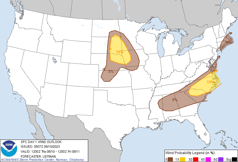
Probabilistic Damaging Wind Graphic
Probability of damaging thunderstorm winds or wind gusts of 50 knots or higher within 25 miles of a point. Hatched Area: 10% of greater probability of wind gusts 65 knots or greater within 25 miles of a point.
Day 1 Wind Risk
Area (sq. mi.)
Area Pop.
Some Larger Population Centers in Risk Area
15 %
126,898
13,877,733
Charlotte, NC...Virginia Beach, VA...Omaha, NE...Raleigh, NC...Norfolk, VA...
SPC AC 100507
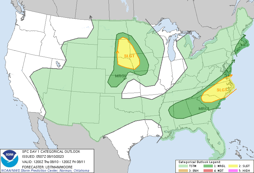
Day 1 Convective Outlook
NWS Storm Prediction Center Norman OK
1207 AM CDT Thu Aug 10 2023
Valid 101200Z - 111200Z
...THERE IS A SLIGHT RISK OF SEVERE THUNDERSTORMS ACROSS PORTIONS OF
THE NORTHERN PLAINS...AND OVER PARTS OF THE CAROLINAS INTO FAR
SOUTHEAST VIRGINIA...
...SUMMARY...
Strong to severe thunderstorms are possible across parts of the
northern Plains, and from the Tennessee Valley to the Mid-Atlantic
on Thursday.
...Southeast to Mid-Atlantic Coast...
A midlevel shortwave trough will be oriented over the OH/TN Valley
vicinity this morning, and pivot east/northeast through the day,
moving offshore the Mid-Atlantic coast by late evening. A belt of
40-60 kt 500 mb west/southwest flow will overspread the region,
supporting organized convection, as effective shear magnitudes
approach 30-40 kt. An MCS will likely be ongoing over the southern
Appalachians this morning, and may deteriorate as it shifts east
through midday. A second area of thunderstorms may then develop
ahead of an eastward-progressing surface low over NC. A moist
airmass, with dewpoints generally in the upper 60s to mid 70s F will
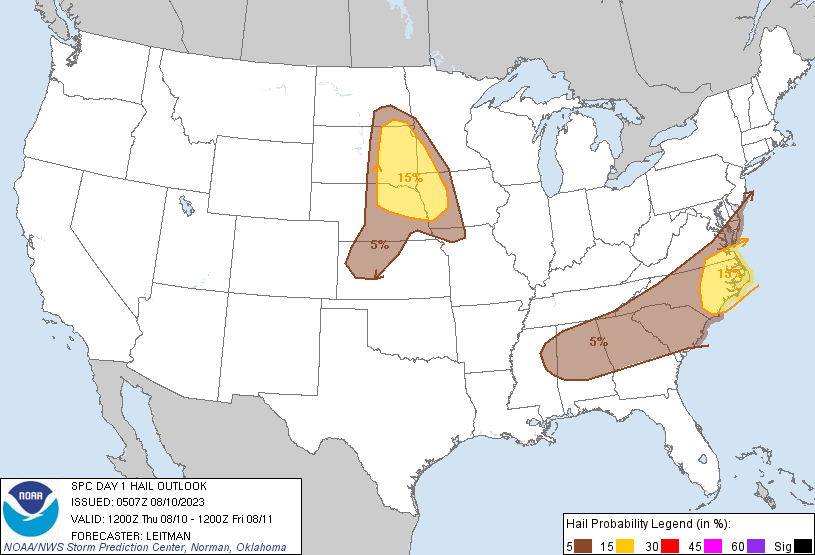
support moderate to strong destabilization by afternoon. Bowing
clusters and perhaps a couple of discrete cells are expected across
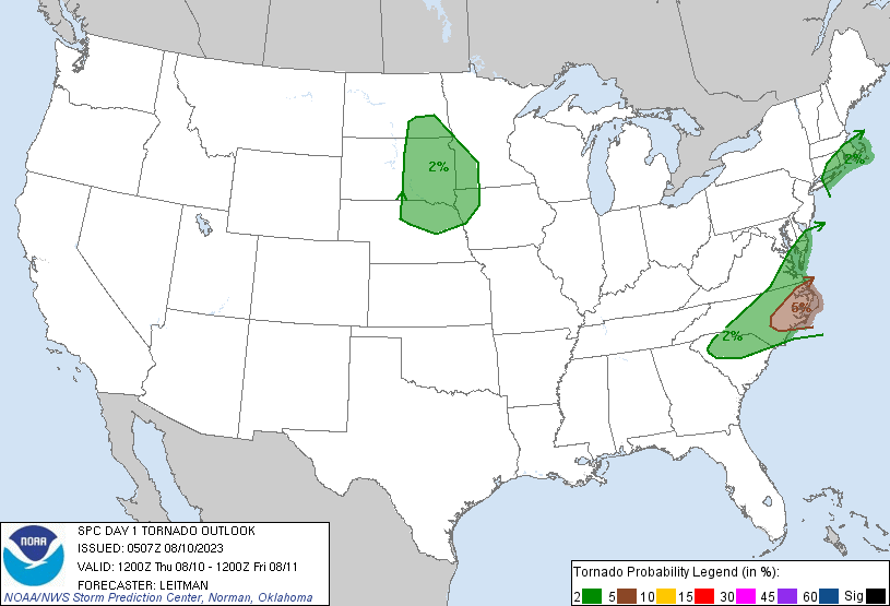
parts of SC/NC toward coastal SE VA. Isolated to scattered damaging
gusts and a couple of tornadoes are possible.
Further to the west, scattered thunderstorms are expected to develop
from northeast MS into AL/GA along residual outflow from prior
convection. While vertical shear will be somewhat weaker across this
area, moderate to strong instability and a very moist airmass will
support clusters of storms capable of isolated damaging gusts.
...Northern Plains vicinity...
The upper ridge over the region will shift east toward the upper
Great Lakes today as a weak midlevel shortwave impulse migrates east
from the northern Rockies to the Upper MS Valley. At the surface, a
cold front will develop eastward across the Dakotas and NE during
the afternoon/evening. Modest boundary-layer moisture amid steep
midlevel lapse rates will foster MLCAPE around 1000-2000 J/kg.
Modestly veering wind profiles, and around 30 kt 0-6 km shear, will
support a mix of semi-discrete cells and clusters. A deeply mixed
boundary-layer will support strong/severe gusts while
elongated/straight hodographs above 2-3 km amid steep midlevel lapse
rates suggest large hail also will be possible.
...Southern New England...
A weak surface low and cold front will shift east across New England
during the afternoon/evening. A seasonally moist airmass will be in
place. However, poor midlevel lapse rates and muted heating due to
cloud cover will largely limit severe potential, though a few strong
gusts are possible with storms across Upstate NY eastward. The best
chance for a severe storm appears to be closer to coastal southern
New England where a better overlap of deeper boundary-layer moisture
and stronger surface heating will occur. A few strong gusts and a
tornado will be possible within this environment.
..Leitman/Moore.. 08/10/2023
CLICK TO GET WUUS01 PTSDY1 PRODUCT
NOTE: THE NEXT DAY 1 OUTLOOK IS SCHEDULED BY 1300Z