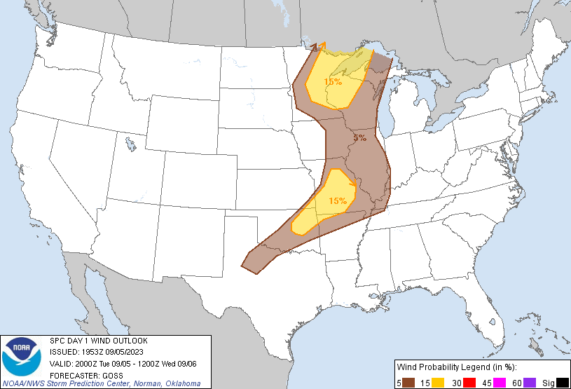
Probability of damaging thunderstorm winds or wind gusts of 50 knots or higher within 25 miles of a point. Hatched Area: 10% of greater probability of wind gusts 65 knots or greater within 25 miles of a point.
Oklahoma City, OK...Tulsa, OK...Springfield, MO...Cedar Rapids, IA...Norman, OK...
SPC AC 051953
Day 1 Convective Outlook
NWS Storm Prediction Center Norman OK
0253 PM CDT Tue Sep 05 2023
Valid 052000Z - 061200Z
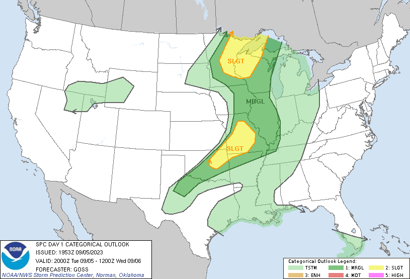
...THERE IS A SLIGHT RISK OF SEVERE THUNDERSTORMS ACROSS PARTS OF
THE UPPER MISSISSIPPI VALLEY/WESTERN UPPER GREAT LAKES REGION...AND
FROM MISSOURI AND VICINITY SOUTHWESTWARD INTO NORTHEASTERN
OKLAHOMA...
...SUMMARY...
Severe thunderstorms are expected this afternoon and evening over
parts of the upper Mississippi Valley/Lake Superior region, and
across the Ozarks and parts of Oklahoma. Severe wind gusts and
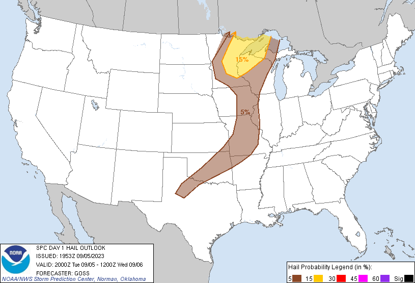
isolated large hail are possible.
...Discussion...
Along with minor line tweaks in a few areas, including some eastward
expansion of thunder into parts of Wyoming for the overnight period,
the only other substantive change at this time is the northward
expansion of SLGT risk/15% wind into parts of northern Missouri.
Here, a similar thermodynamic pre-frontal environment is indicated
as compared to areas a bit farther south, and several CAM runs are
indicating development along the front may extend a bit farther
north than previously hinted at in the outlook.
Otherwise, expectations remain similar to those in prior outlooks.
..Goss.. 09/05/2023
.PREV DISCUSSION... /ISSUED 1131 AM CDT Tue Sep 05 2023/
...Upper Mississippi Valley...
A shortwave trough over the Dakotas this morning will continue
eastward toward the upper Mississippi Valley through tonight. A
slight cooling of mid-level temperatures (-10C at 500 mb) will
accompany this trough, while only a modest strengthening of
trough-preceding winds aloft is expected, given that the trough is
somewhat removed from the stronger westerlies over the Canadian
prairies.
While some warm-sector cloud cover persists early today regionally,
the boundary layer ahead of an eastward-moving cold front should
become minimally inhibited by early into mid-afternoon, with MLCAPE
reaching 2500+ J/kg especially across the eastern halves of
Minnesota and Iowa, as well as much of western Wisconsin and far
northwest Illinois. Initial thunderstorm intensification is expected
this afternoon across northern/central Minnesota, potentially with
an ongoing band of storms across northern Minnesota, and more so
near the aforementioned front and surface wave, with subsequent
scattered development southward into southeast Minnesota/eastern
Iowa and western Wisconsin through late afternoon and early evening.
Severe wind gusts and hail will be possible with a mixed mode of
storms including multicells and some transient supercells. Some
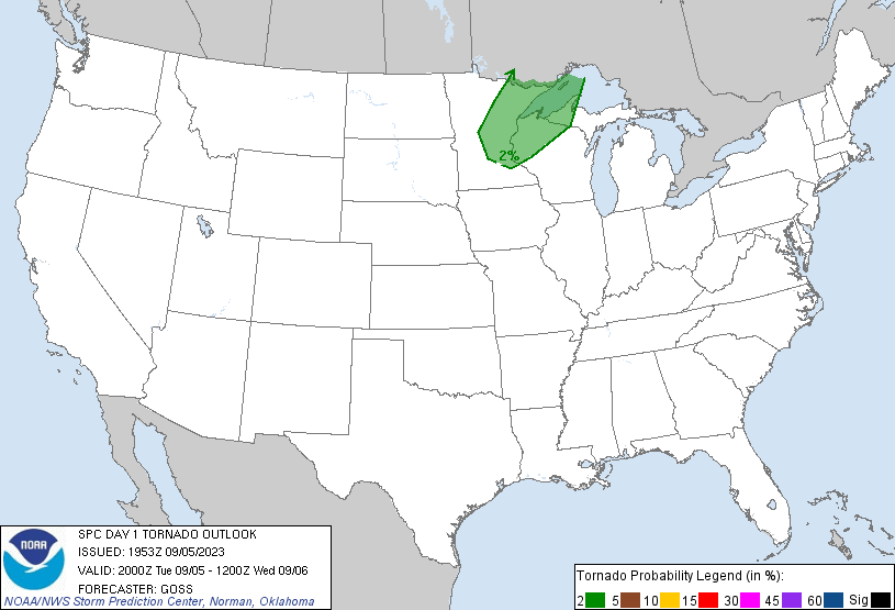
tornado risk may exist as well, mainly across northeast
Minnesota/northwest Wisconsin.
...Middle Mississippi Valley/Ozarks/southern Plains...
Widely scattered mid-level convection across the region trails a
shortwave trough centered generally near the confluence of the
Mississippi/Ohio Rivers. This convection is atop a warm-sector
boundary layer that will heat and become strongly unstable by peak
heating, particularly across eastern Oklahoma into Missouri
western/northern Arkansas ahead of an east/southeastward-moving
front.
Isolated to widely scattered thunderstorms are expected to develop
by mid/late afternoon near the front, and somewhat across the warm
sector, potentially influenced by lingering cloud cover/zones of
differential heating. While tropospheric winds will only be modest
strength (effective shear less than 30 kt), strong heating, steep
lapse rates, and ample buoyancy will support the potential for
severe-caliber wind gusts, especially with the aforementioned
corridor of greatest destabilization. Some severe hail may occur as
well.
CLICK TO GET WUUS01 PTSDY1 PRODUCT
NOTE: THE NEXT DAY 1 OUTLOOK IS SCHEDULED BY 0100Z