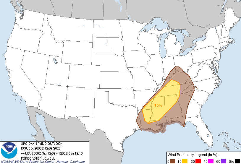
Probability of damaging thunderstorm winds or wind gusts of 50 knots or higher within 25 miles of a point. Hatched Area: 10% of greater probability of wind gusts 65 knots or greater within 25 miles of a point.
SPC AC 092003
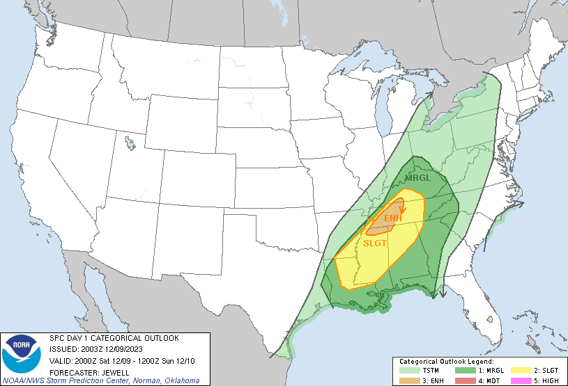
Day 1 Convective Outlook
NWS Storm Prediction Center Norman OK
0203 PM CST Sat Dec 09 2023
Valid 092000Z - 101200Z
...THERE IS AN ENHANCED RISK OF SEVERE THUNDERSTORMS OVER WESTERN
AND MIDDLE TENNESEE...AND SMALL PARTS OF NORTHERN MISSISSIPPI AND
FAR SOUTHERN KENTUCKY...
...SUMMARY...
Several tornadoes, scattered large hail and areas of damaging winds
are expected through the afternoon into the evening from portions of
the Ohio and Tennessee Valleys southward to the Lower Mississippi
Valley and middle Gulf Coast.
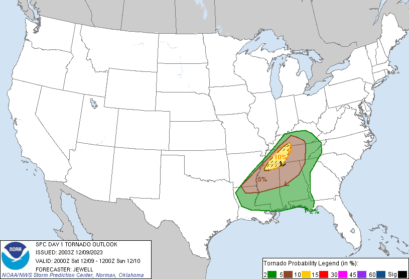
...Lower MS Valley into much of TN and southern KY...
Tornado probabilities have been increased within an Enhanced Risk
for the unfolding tornado situation over western into Middle TN and
far southern KY, and extending into northern MS.
Cells have remained discrete and are currently within a developing
instability plume, adjacent to an area of enhanced low-level shear
over Middle TN, southern KY and northern MS. The combination of
favorable storm mode, and fully-effective 0-1 SRH of 150-200 m2/s2
will pose a damaging tornado risk through the late afternoon. The
greatest threat area may remain relatively concentrated due to the
cooler air mass to the east, but an isolated strong tornado or two
is possible.
For more information, see mesoscale discussion 2305.
..Jewell.. 12/09/2023
.PREV DISCUSSION... /ISSUED 1036 AM CST Sat Dec 09 2023/
...Gulf Coast/Lower Mississippi Valley/Tennessee Valley...
Region is being increasingly influenced by height falls but
otherwise resides between larger scale influences of an upper trough
over the Upper Midwest and a positive-tilt trough over the southern
High Plains. Increasing warm-sector moisture (generally lower to
some middle 60s F surface dewpoints) ahead of a southeastward-moving
cold front, along with considerable deep-layer/low-level shear, will
be favorable factors for a long-duration severe risk through the
afternoon into tonight. However, the likelihood of a complex/mixed
quasi-linear convective mode casts uncertainty regarding the
magnitude of the severe risk, particularly regarding a
supercell-related sustained/focused tornado risk. It is also noted
that some guidance suggests that 1-3km AGL winds may somewhat weaken
by late afternoon/early evening within the warm sector, while noting
SRH will still remain favorable for rotating/severe storms.
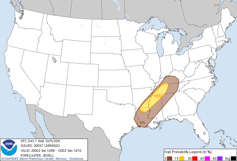
Storms should continue to increase in coverage through early
afternoon, initially near the front across Arkansas northeastward
into western portions of Tennessee/Kentucky. Sufficiently steep
mid-level lapse rates will support some hail potential, especially
the first part of the day, but the tendency for storm clustering
will otherwise limit this overall potential, as well as limiting
prospects for more consequential hail magnitudes. As the boundary
layer warms this afternoon, the potential for initially
semi-discrete supercells will increase along with related damaging
wind risk as well as tornado potential, which will persist through
the afternoon/evening even with a quasi-linear convective mode.
As warm-sector inhibition further weakens later this afternoon,
additional deepening convection may develop within weak pre-frontal
convergence/confluence regime, mainly across Mississippi into
Alabama, with this development eventually merging with or taking
over as the main convective band this evening. Similarly,
pre-frontal confluence may support isolated supercellular
development along the Gulf Coast/Florida Panhandle vicinity through
late night hours/early Sunday, within a somewhat separate regime
capable of a few severe storms.
CLICK TO GET WUUS01 PTSDY1 PRODUCT
NOTE: THE NEXT DAY 1 OUTLOOK IS SCHEDULED BY 0100Z