Probability of damaging thunderstorm winds or wind gusts of 50 knots or higher within 25 miles of a point. Hatched Area: 10% of greater probability of wind gusts 65 knots or greater within 25 miles of a point.
Memphis, TN...Boston, MA...Kansas City, MO...Omaha, NE...Tulsa, OK...
Probabilistic Large Hail Graphic
Probability of hail 1" or larger within 25 miles of a point. Hatched Area: 10% or greater probability of hail 2" or larger within 25 miles of a point.
Day 2 Hail Risk
Area (sq. mi.)
Area Pop.
Some Larger Population Centers in Risk Area
SIG SEVERE
45,626
259,910
North Platte, NE...Scottsbluff, NE...Sterling, CO...Fort Morgan, CO...
30 %
13,104
75,174
Sterling, CO...
15 %
71,950
675,583
Salina, KS...Grand Island, NE...Kearney, NE...North Platte, NE...Hastings, NE...
5 %
106,463
2,949,248
Wichita, KS...Lincoln, NE...Topeka, KS...Greeley, CO...Rapid City, SD...
SPC AC 071730
Day 2 Convective Outlook
NWS Storm Prediction Center Norman OK
1230 PM CDT Mon Aug 07 2023
Valid 081200Z - 091200Z
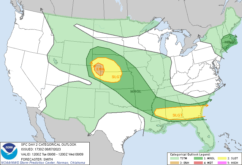
...THERE IS AN ENHANCED RISK OF SEVERE THUNDERSTORMS NORTHEAST
COLORADO...SOUTHWEST NEBRASKA...AND FAR NORTHWEST KANSAS...
...THERE IS A SLIGHT RISK OF SEVERE THUNDERSTORMS FROM CENTRAL
MISSISSIPPI EASTWARD INTO SOUTHERN GEORGIA...
...SUMMARY...
Scattered severe thunderstorms are possible across portions of the
central High Plains Tuesday afternoon into Tuesday night. Large to
very large hail along with a risk for a tornado and widely scattered
severe gusts will be the potential hazards.
...Synopsis...
Water-vapor imagery midday Monday shows a potent mid-level shortwave
trough over the Pacific Northwest. This feature is forecast to be
over the northern Intermountain region Tuesday morning and move
east-southeast through the central Rockies during the period.
Farther east, a mid-level trough over the Lower Great Lakes
southward into the Mid-Atlantic states will pivot eastward and be
located to the east of the New England coast by late Tuesday night.
At the surface, low pressure near Lake Ontario will shift northeast
along the St. Lawrence Valley. A cold front attendant to the low
will develop eastward across southern New England through the day
and offshore the northeast Atlantic coast during the
evening/overnight. The southern extent of the front will stall over
South Carolina. Southerly low-level flow will maintain a very moist
airmass from the central Plains into the Southeast.
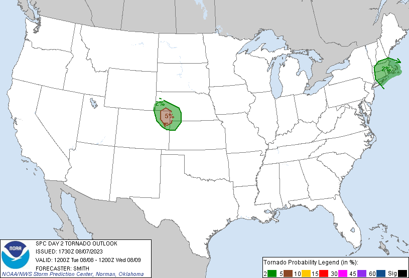
...Central Plains...
Large-scale ascent associated with the aforementioned disturbance
will overspread the central High Plains by mid-late afternoon.
Low-level upslope flow will maintain a moist airmass from northwest
KS towards the Cheyenne Ridge and feature dewpoints ranging through
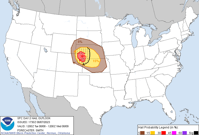
the 50s and into the 60s over northwest KS/southwest NE. Steep
700-500 mb lapse rates near 8 C/km atop the moist boundary-layer
will support MLCAPE around 2000-3000 J/kg. Elongated hodographs
will favor supercells with the stronger updrafts through the early
evening. The relatively moist conditions centered over northeast CO
could yield a focus risk for a tornado during the early evening, in
addition to the threat for large to very large hail (diameters 2 to
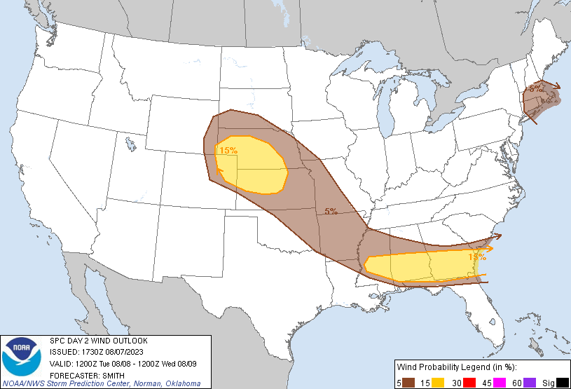
3 inches). A 30-kt southerly LLJ is forecast to develop during the
evening/overnight with the terminus located within an 850-mb moist
axis. Considered higher severe-wind probabilities adjoining to the
east of the 30-percent severe hail probabilities but uncertainty
remained high regarding the convective morphology/orientation of
storms as the activity moves into north-central KS/southern NE.
...Southeast...
Residual outflow from convection in the Day 1 period will likely
reside from northern MS into central AL/GA. This will result in
differential heating ahead of convection expected to be ongoing
across eastern OK/AR Tuesday morning in response to a vorticity
maximum migrating through northwesterly flow aloft. As this
convectively enhanced vorticity max and related MCV shifts east by
early afternoon, thunderstorm are expected to increase rapidly
intensify from central MS east into AL during the early-mid
afternoon. An organized cluster/MCS is forecast to spread east
across central/southern AL/GA during the afternoon and reach
southern GA by early evening. Very high PW (2+ inches) and around
4000 J/kg MLCAPE forecast downstream of the evolving thunderstorm
complex will likely result in isolated severe gusts and at least
widely scattered wind damage.
...Southern New England...
Storms will likely be ongoing Tuesday morning in a warm advection
band ahead of the surface cold front. Backed low-level winds and
proximity to the surface low will result in 0-1 km SRH around
than 250 s2/m2. Weak lapse rates will limit updraft intensity, but
very moist low-levels coupled with the low-level shear will support
an environment conditionally favorable for storm rotation. The
severe threat will probably diminish by midday as the warm
advection-related storms shift northeast and move into the adjacent
Atlantic waters.
..Smith.. 08/07/2023
CLICK TO GET WUUS02 PTSDY2 PRODUCT
NOTE: THE NEXT DAY 2 OUTLOOK IS SCHEDULED BY 0600Z