Probability of a tornado within 25 miles of a point. Hatched Area: 10% or greater probability of EF2 - EF5 tornadoes within 25 miles of a point.
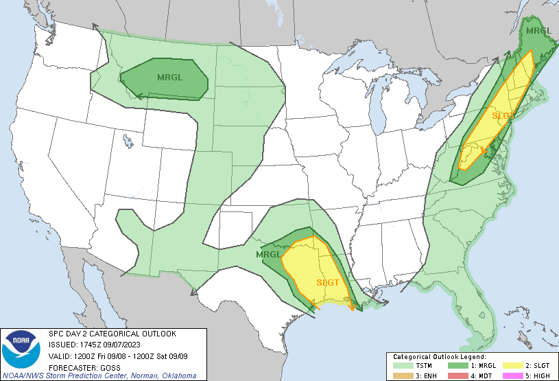
Day 2 Tornado Risk
Area (sq. mi.)
Area Pop.
Some Larger Population Centers in Risk Area
No Risk Areas Forecast
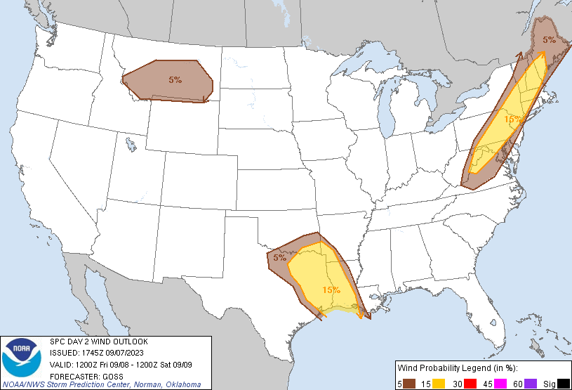
Probabilistic Damaging Wind Graphic
Probability of damaging thunderstorm winds or wind gusts of 50 knots or higher within 25 miles of a point. Hatched Area: 10% of greater probability of wind gusts 65 knots or greater within 25 miles of a point.
Day 2 Wind Risk
Area (sq. mi.)
Area Pop.
Some Larger Population Centers in Risk Area
15 %
148,972
40,279,300
New York, NY...Dallas, TX...Fort Worth, TX...Baltimore, MD...Arlington, TX...
Probability of hail 1" or larger within 25 miles of a point. Hatched Area: 10% or greater probability of hail 2" or larger within 25 miles of a point.
Day 2 Hail Risk
Area (sq. mi.)
Area Pop.
Some Larger Population Centers in Risk Area
5 %
270,381
68,098,396
New York, NY...Houston, TX...Philadelphia, PA...Dallas, TX...Fort Worth, TX...
   SPC AC 071745

   Day 2 Convective Outlook
   NWS Storm Prediction Center Norman OK
   1245 PM CDT Thu Sep 07 2023

   Valid 081200Z - 091200Z

   ...THERE IS A SLIGHT RISK OF SEVERE THUNDERSTORMS ACROSS EASTERN
   PORTIONS OF THE SOUTHERN PLAINS AND ACROSS THE SABINE RIVER
   VALLEY...AND OVER PARTS OF THE NORTHEAST AND MID-ATLANTIC REGION...

   ...SUMMARY...
   Thunderstorms, associated with a marginal severe threat, will be
   possible on Friday across parts of the Northeast, Central
   Appalachians, Mid-Atlantic, Ark-La-Tex and Northern High Plains.

   ...Southeastern Oklahoma/eastern Texas/southwestern Arkansas/western
   Louisiana...
   Thunderstorms are forecast to be ongoing at the start of the period
   across parts of the eastern Oklahoma/western Arkansas region,
   possibly accompanied by some ongoing potential for strong
   winds/hail.  A strong model signal remains apparent that storms will
   shift southward with time, strengthening gradually as daytime
   heating results in a corridor of moderate instability.

   Given a belt of 35 to 45 kt mid-level north-northwesterly flow
   around the eastern fringe of the southwestern U.S. upper ridge,
   potential for an organized MCS moving quickly southward roughly
   along the Sabine River Valley through the day may evolve.  In this
   scenario, potential for damaging winds would be expected, along with
   some hail, with the risk shifting southward and likely reaching the
   Gulf Coast by late afternoon.

   While less certain, some hints exist within some models that late
   evening/overnight redevelopment of storms could occur on the western
   flank/remnant outflow from this initial band of storms, across the
   north-central Texas vicinity, with potential for a
   second/southeastward-moving MCS.  These storms -- should they
   develop/organize, could also pose risk for hail and damaging winds
   through the overnight period.

   ...The Northeast and Mid-Atlantic region...
   Afternoon heating/destabilization is expected along and east of the
   Appalachians Friday, near a weak/stalled surface front.
   Terrain-induced ascent, and lift near the front, will result in
   scattered thunderstorm development during the afternoon,
   particularly from the mountains of Virginia and West Virginia
   northeastward into New England.

   With a belt of 25 to 35 kt south-southwesterly flow across this
   area, on the eastern fringe of the mid-level trough positioned over
   the Midwest/Tennessee Valley, shear will support a few organized
   storms/storm clusters.  As these clusters shift northeastward,
   locally damaging wind gusts can be expected, lingering into the
   early evening hours before storms begin to nocturnally weaken.

   ...Northern Intermountain region...
   Daytime heating across the northern Intermountain region will result
   in modest destabilization, with mixed-layer CAPE averaging 500 J/kg
   during the afternoon atop a deep mixed layer.  As a short-wave
   trough at mid levels sweeps eastward across the region, isolated to
   widely scattered thunderstorm development is expected, with peak
   convective coverage anticipated from late afternoon through mid
   evening.  With a belt of 30 to 40 kt mid-level westerlies
   accompanying the short-wave trough, and potential for sub-cloud
   evaporative effects, a few stronger/longer-lived storms may produce
   gusty/locally damaging winds.

   ..Goss.. 09/07/2023

   CLICK TO GET WUUS02 PTSDY2 PRODUCT

   NOTE: THE NEXT DAY 2 OUTLOOK IS SCHEDULED BY 0600Z