SPC AC 200800
Day 3 Convective Outlook
NWS Storm Prediction Center Norman OK
0200 AM CST Fri Jan 20 2023
Valid 221200Z - 231200Z
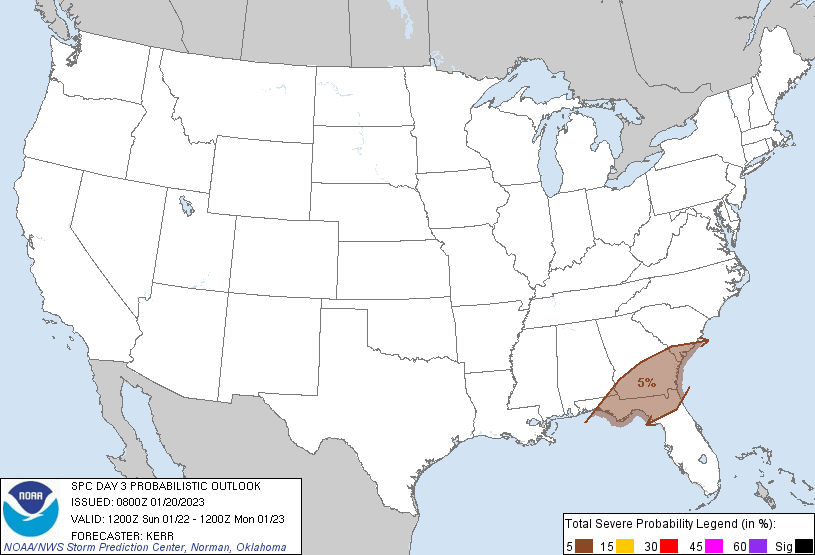
...THERE IS A MARGINAL RISK OF SEVERE THUNDERSTORMS SUNDAY ACROSS
PARTS OF NORTHERN FLORIDA...SOUTHEASTERN ALABAMA...MUCH OF SOUTHERN
GEORGIA AND ADJACENT SOUTHERN SOUTH CAROLINA...
...SUMMARY...
A couple of strong thunderstorms may impact parts of southern
Georgia, northern Florida and portions of adjacent states Sunday,
accompanied by at least some potential for producing damaging wind
gusts and tornadoes.
...Synopsis...
Latest model output indicates that amplified mid-level ridging, with
an embedded high, will remain prominent across the eastern Pacific
into U.S. Pacific coastal areas through this period. At the same
time, a western Atlantic subtropical high may continue to build
west-northwestward across the Caribbean and Bahamas, while a
significant mid-level low develops west-southwestward across the
northeastern Canadian Arctic latitudes. In between, short wave
developments within split branches of westerlies across much of
North America remain unclear, with substantial spread still evident
in model output, particularly inland of the U.S. Pacific coast
through the Atlantic Seaboard.
In general, it appears that one consolidating mid-level trough will
accelerate from the lower Missouri Valley/southern Great Plains
vicinity toward the Atlantic Seaboard, as a more prominent upstream
perturbation digs south-southeastward across the Intermountain West
and Rockies vicinity. Models indicate that the lead impulse may
eventually support significant surface cyclogenesis along a remnant
frontal zone initially advancing inland across parts of the
Southeast. However, latest output continues to suggest that the most
substantive deepening may not occur until Sunday night, mainly
offshore, from near the southern Mid Atlantic toward southern New
England coasts.
...Southeast...
Coinciding with the frontal wave, southerly return flow emanating
from the Gulf of Mexico may continue to moisten across the region
Sunday. Associated destabilization, potentially supportive of
thunderstorm development inland of the Gulf of Mexico, will largely
be confined to the cool side of the front initially. However,
models indicate that weak boundary-layer moistening and
destabilization may accompany the inland-migrating low across the
Florida Panhandle into southern Georgia during the morning into
afternoon. If this occurs, it appears that it will do so in the
presence of 40-60+ kt southwesterly to west-southwesterly flow in
the 850-500 mb layer, with forecast hodographs becoming conducive to
organized convection. This may include a couple of discrete
supercell structures with potential to produce locally strong
surface gusts and/or tornadoes, before the favorable large-scale
forcing develops offshore of the south Atlantic coast by Sunday
evening.
..Kerr.. 01/20/2023
CLICK TO GET WUUS03 PTSDY3 PRODUCT
NOTE: THE NEXT DAY 3 OUTLOOK IS SCHEDULED BY 0830Z