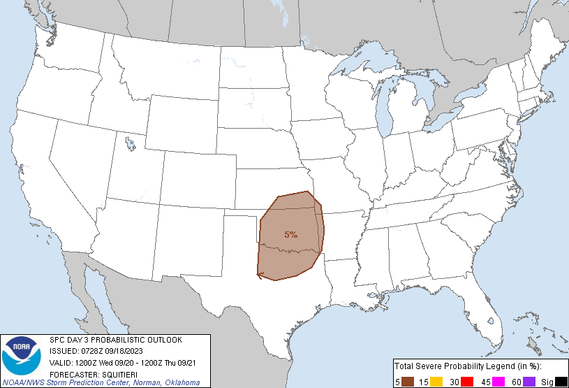
Dallas, TX...Fort Worth, TX...Oklahoma City, OK...Tulsa, OK...Arlington, TX...
Probabilistic Graphic
Probability of severe weather within 25 miles of a point. Hatched Area: 10% or greater probability of significant severe within 25 miles of a point.
Day 3 Prob. Risk
Area (sq. mi.)
Area Pop.
Some Larger Population Centers in Risk Area
5 %
122,336
12,913,422
Dallas, TX...Fort Worth, TX...Oklahoma City, OK...Tulsa, OK...Arlington, TX...
SPC AC 180728
Day 3 Convective Outlook
NWS Storm Prediction Center Norman OK
0228 AM CDT Mon Sep 18 2023
Valid 201200Z - 211200Z
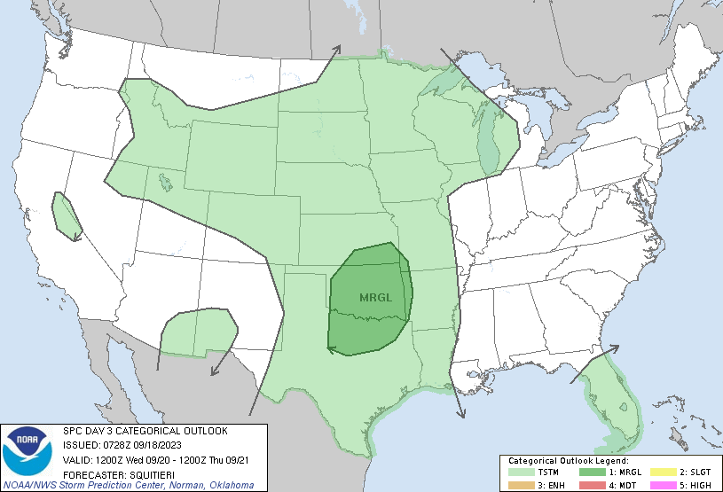
...THERE IS A MARGINAL RISK OF SEVERE THUNDERSTORMS OVER PARTS OF
THE SOUTHERN PLAINS...
...SUMMARY...
Isolated strong to severe thunderstorms are possible across the
southern Plains Wednesday afternoon and evening.
...Synopsis...
Embedded perturbations within zonal mid-level flow will de-amplify
as they move away from the southern Plains, followed by an upper
ridge impinging on the Plains states by Wednesday afternoon.
However, amplification of a mid-level trough across the Interior
West will prompt surface lee troughing and southerly low-level
moisture return across the Plains states, fostering at least
scattered thunderstorm potential. Latest guidance consensus suggests
that adequate buoyancy may develop across the warm sector over
portions of the southern Plains to support isolated strong to
potentially severe thunderstorms Wednesday afternoon and evening.
...Portions of the southern Plains...
Scattered thunderstorms are expected to be ongoing across central OK
into north TX at the start of the period. As the afternoon
progresses, upper ridging should build over the southern Plains,
coinciding with weakening of the early-day storms and increased
surface heating. As surface lee troughing intensifies over the
southern Plains, 60-65 F surface dewpoints should advect
northwestward beneath 7-8 C/km mid-level lapse rates, with MLCAPE
potentially reaching 2000-2500 J/kg by afternoon peak heating.
Strengthening northwesterly mid to upper flow with the approaching
upper ridge will contribute to elongated hodographs and 30-40 kts of
effective bulk shear. Given early day convection and expected height
rises with the approaching upper ridge, overall confidence in an
organized round of severe thunderstorms is low. Nonetheless, any
storm that manages to develop and become sustained in the
aforementioned kinematic/thermodynamic environment may become
briefly supercellular, supporting an isolated severe hail/wind risk.
...Portions of the northern Plains into the Upper MS Valley...
Synoptic-scale deep-layer ascent and vertical shear is expected to
be weak across the northern Plains into the Upper MS Valley,
limiting convective coverage. However, 7 C/km mid-level lapse rates
overspreading 55-60 F surface dewpoints along a near-stationary
surface boundary will boost SBCAPE into the 1000-1500 J/kg range. It
is not out of the question that a couple of stronger thunderstorms
could produce some hail/wind approaching severe limits. However,
confidence in this scenario is too low to warrant severe
probabilities this outlook.
..Squitieri.. 09/18/2023
CLICK TO GET WUUS03 PTSDY3 PRODUCT
NOTE: THE NEXT DAY 3 OUTLOOK IS SCHEDULED BY 0730Z