Probability of damaging thunderstorm winds or wind gusts of 50 knots or higher within 25 miles of a point. Hatched Area: 10% of greater probability of wind gusts 65 knots or greater within 25 miles of a point.
SPC AC 021622
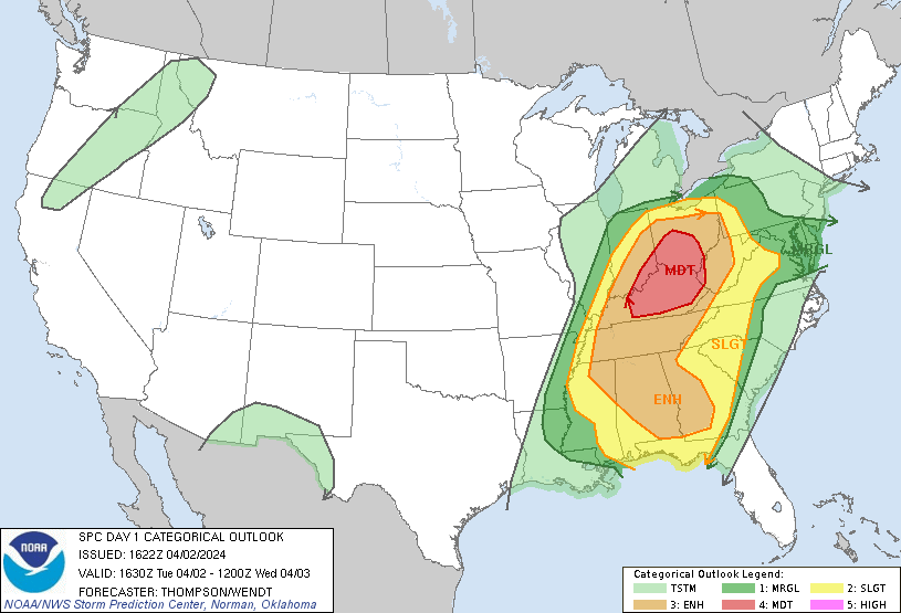
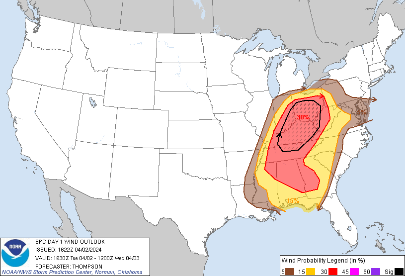
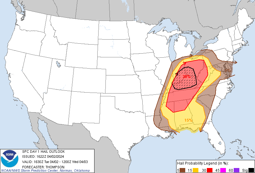
Day 1 Convective Outlook
NWS Storm Prediction Center Norman OK
1122 AM CDT Tue Apr 02 2024
Valid 021630Z - 031200Z
...THERE IS A MODERATE RISK OF SEVERE THUNDERSTORMS THIS
AFTERNOON/EVENING FOR CENTRAL/EASTERN KY...SOUTHEAST IN...SOUTHERN
OH...AND FAR WESTERN WV...
...SUMMARY...
A severe weather outbreak is possible through this evening over the
Ohio Valley with the broader severe weather risk including parts of
the Southeast. Strong and potentially long-track tornadoes are
possible from Indiana and Ohio southward into the Mid South. A
threat for strong tornadoes may focus this evening into tonight
across parts of Alabama and Georgia.
...OH/TN Valley area through this evening...
Complex scenario late this morning with ongoing convection across
WV, trailing outflow to the west across KY, and another cluster of
storms moving into the trailing outflow zone across TN/KY. The lead
storms have produced damaging winds (up to 92 mph measured), though
this line of storms should weaken near or just after midday as it
encounters the remnant cool air wedge close to the WV/VA border.
The storms farther west will move along the remnant outflow zone,
where surface temperatures are in the low-mid 70s with dewpoints of
65-70 F. A couple of the storms will likely become persistent
supercells capable of producing tornadoes (some of which could be
strong/EF2-3) given the already strong wind profiles/long hodographs
with effective SRH of 200-300 m2/s2.
Uncertainty is relatively high for areas north of the ongoing
TN-KY-WV convection. The storms approaching middle TN and southern
KY will tend to reinforce the earlier outflow, which will likely
interfere with/limit destabilization this afternoon toward parts of
OH (especially eastern OH). The corridor of richer low-level
moisture from northeast AR into southeast MO (immediately west of
the TN storms) suggests that air mass recovery will occur toward
southern IL and southern/central IN by late morning into early
afternoon, and southwest OH this afternoon. Strong deep-layer
shear/long hodographs associated with an amplifying midlevel
trough/jet and a deepening surface cyclone will support the
potential for fast-moving supercells capable of all severe hazards,
including strong tornadoes where sufficient low-level
warming/moistening occurs in the wake of the morning convection. As
previously mentioned, the northeastern extent of the primary severe
threat into OH is more uncertain given the ongoing convection to the
south, but will trim the northeast edge of the MDT risk area and
expand south some to account for the outflow corridor enhancing the
tornado threat on the mesoscale across KY.
...Eastern AL/western GA overnight...
In response to the amplifying midlevel trough/deepening cyclone over
the MS/OH Valleys, deep-layer flow and low-level moisture advection
will increase tonight across AL/GA. A surge of upper 60s
boundary-layer dewpoints and strengthening low-level shear both
appear supportive of supercells/tornadoes overnight in a broken band
ahead of the synoptic cold front. An isolated strong tornado or two
will be possible.
..Thompson/Wendt.. 04/02/2024
CLICK TO GET WUUS01 PTSDY1 PRODUCT
NOTE: THE NEXT DAY 1 OUTLOOK IS SCHEDULED BY 2000Z