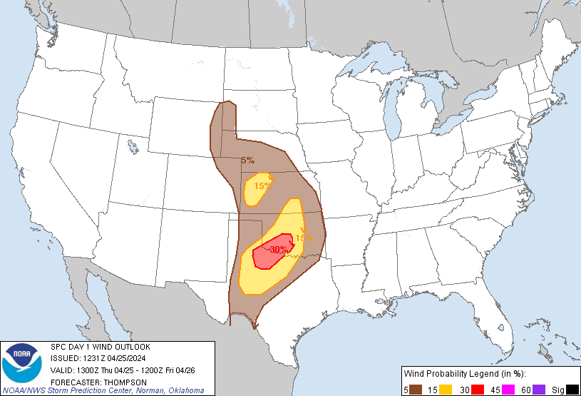
Probability of damaging thunderstorm winds or wind gusts of 50 knots or higher within 25 miles of a point. Hatched Area: 10% of greater probability of wind gusts 65 knots or greater within 25 miles of a point.
Day 1 Wind Risk
Area (sq. mi.)
Area Pop.
Some Larger Population Centers in Risk Area
30 %
22,030
1,177,932
Oklahoma City, OK...Norman, OK...Wichita Falls, TX...Lawton, OK...Moore, OK...
SPC AC 251231
Day 1 Convective Outlook
NWS Storm Prediction Center Norman OK
0731 AM CDT Thu Apr 25 2024
Valid 251300Z - 261200Z
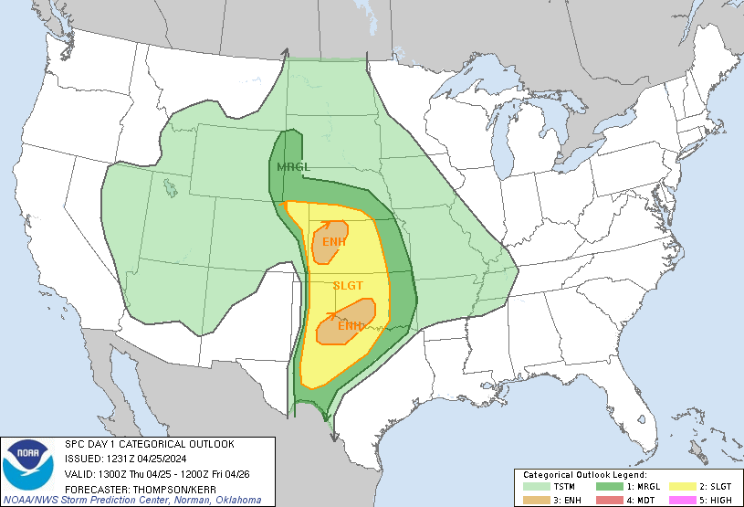
...THERE IS AN ENHANCED RISK OF SEVERE THUNDERSTORMS THIS EVENING
ACROSS WESTERN KS AND TONIGHT ACROSS NORTHWEST TX INTO CENTRAL OK...
...SUMMARY...
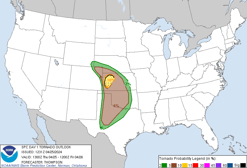
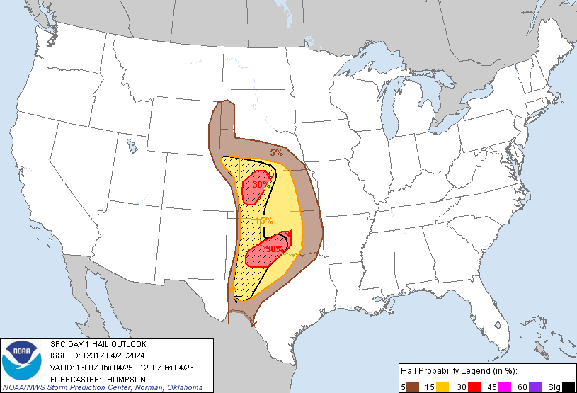
Very large hail up to 3 inches in diameter and a strong tornado or
two will be possible this evening across western Kansas. Large hail
up to 2.5 inches in diameter, damaging winds to 70 mph and a few
tornadoes will be possible tonight from northwest Texas into central
Oklahoma.
...Synopsis...
A midlevel shortwave trough and associated 70 kt jet will eject
northeastward toward western KS by late tonight and Friday morning.
An associated lee cyclone is expected to deepen this afternoon
across northeast CO, with a sharpening dryline arcing to its south
across western KS and the TX/OK Panhandles. Farther east, a warm
front will continue to move northward from OK into KS, though
northward progress of the front will be slowed by elevated
convection (posing an isolated large hail threat) that will
reinforce the cool side of the boundary during the day. A somewhat
bimodal threat distribution is expected - the warm sector in western
KS and a second corridor overnight from northwest TX into OK.
...Western KS this afternoon/evening...
An unstable warm sector will be present through this evening, with
boundary-layer dewpoints in the 60s beneath steep midlevel lapse
rates. The base of the elevated mixed layer will be relatively
warm, suggesting the need for surface temperatures into the 80s on
the immediate moist side of the dryline. The better potential for
storm development this afternoon will be across western KS, where
dryline parcel residence times will be longer and in closer
proximity to the left-exit region of the approaching mid-upper jet.
The initial dryline storms will likely become supercells capable of
producing very large hail of 2-3 inches in diameter, and these
storms could continue northeastward as elevated supercells atop the
warm front. The potential for a strong tornado or two will increase
this evening as the storms encounter richer low-level moisture and
increasing low-level shear. However, the window of opportunity will
not be particularly large given the presence of a rain-reinforced
front to the northeast and increasing convective inhibition by late
evening.
...Northwest TX into OK overnight...
A general consensus of most overnight forecast guidance suggests a
southern corridor of greater hail/wind threat starting early tonight
just off the Caprock and then spreading northeastward over northwest
TX into southwest/central OK early Friday morning. Thunderstorm
initiation will become more probable by 03-06z in association with
cooling/moistening at the base of the elevated mixed layer,
coincident with the beginning of eastward movement of the
dryline/Pacific cold front along the trailing influence of the
ejecting midlevel trough. Storm mode will likely trend to
clusters/line segments while spreading northeastward.
Boundary-layer dewpoints approaching the upper 60s beneath steep
midlevel lapse rates will contribute to MUCAPE in excess of 2000
J/kg through the overnight hours, which will favor the potential for
both large hail (especially with any embedded supercells) and
damaging winds of 60-70 mph. A few tornadoes may also occur with
embedded circulations as low-level shear increases tonight.
...TX Panhandle/western OK this afternoon/evening...
A conditionally favorable environment for supercells with very large
hail and tornadoes will exist this afternoon/evening across the
eastern TX Panhandle into western OK. The primary uncertainty here
will be lingering convective inhibition and substantial uncertainty
in storm coverage/location along the dryline. For these reasons,
have lowered the overall severe threat, but maintained some
conditional significant severe potential.
..Thompson/Kerr.. 04/25/2024
CLICK TO GET WUUS01 PTSDY1 PRODUCT
NOTE: THE NEXT DAY 1 OUTLOOK IS SCHEDULED BY 1630Z