|
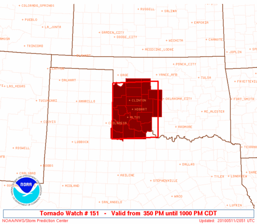
Initial List of Counties in SPC Tornado Watch 151 (WOU)
|
Back to Watch 151
|
 |
   WOUS64 KWNS 112045
   WOU1

   BULLETIN - IMMEDIATE BROADCAST REQUESTED
   TORNADO WATCH OUTLINE UPDATE FOR WT 151
   NWS STORM PREDICTION CENTER NORMAN OK
   350 PM CDT TUE MAY 11 2010

   TORNADO WATCH 151 IS IN EFFECT UNTIL 1000 PM CDT FOR THE
    FOLLOWING LOCATIONS

   OKC009-011-015-017-031-033-039-043-051-055-057-065-075-129-141-
   149-120300-
   /O.NEW.KWNS.TO.A.0151.100511T2050Z-100512T0300Z/

   OK
   .    OKLAHOMA COUNTIES INCLUDED ARE

   BECKHAM              BLAINE              CADDO
   CANADIAN             COMANCHE            COTTON
   CUSTER               DEWEY               GRADY
   GREER                HARMON              JACKSON
   KIOWA                ROGER MILLS         TILLMAN
   WASHITA


   TXC155-197-485-487-120300-
   /O.NEW.KWNS.TO.A.0151.100511T2050Z-100512T0300Z/

   TX
   .    TEXAS COUNTIES INCLUDED ARE

   FOARD                HARDEMAN            WICHITA
   WILBARGER


   ATTN...WFO...OUN...
|
| Aviation Watch (SAW) for WW151 |
|---|
 |
| Note:
The Aviation Watch (SAW) product is an approximation to the watch area.
The actual watch is depicted by the shaded areas. |
   SAW1
   WW 151 TORNADO OK TX 112050Z - 120300Z
   AXIS..75 STATUTE MILES NORTH AND SOUTH OF LINE..
   10SE CHK/CHICKASHA OK/ - 45WNW LTS/ALTUS OK/
   ..AVIATION COORDS.. 65NM N/S /25SSW OKC - 34NNE CDS/
   HAIL SURFACE AND ALOFT..3 INCHES. WIND GUSTS..60 KNOTS.
   MAX TOPS TO 500. MEAN STORM MOTION VECTOR 24030.

   LAT...LON 33909784 33810000 35970000 36089784

   THIS IS AN APPROXIMATION TO THE WATCH AREA.  FOR A
   COMPLETE DEPICTION OF THE WATCH SEE WOUS64 KWNS
   FOR WOU1.
|
|


 @NWSSPC
