|
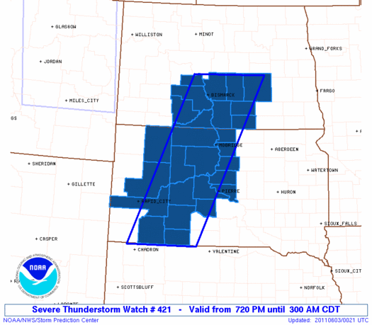
Initial List of Counties in SPC Severe Thunderstorm Watch 421 (WOU)
|
Back to Watch 421
|
 |
   WOUS64 KWNS 030018
   WOU1

   BULLETIN - IMMEDIATE BROADCAST REQUESTED
   SEVERE THUNDERSTORM WATCH OUTLINE UPDATE FOR WS 421
   NWS STORM PREDICTION CENTER NORMAN OK
   720 PM CDT THU JUN 2 2011

   SEVERE THUNDERSTORM WATCH 421 IS IN EFFECT UNTIL 300 AM CDT
   FOR THE FOLLOWING LOCATIONS

   NDC015-029-037-043-047-051-059-065-085-093-030800-
   /O.NEW.KWNS.SV.A.0421.110603T0020Z-110603T0800Z/

   ND
   .    NORTH DAKOTA COUNTIES INCLUDED ARE

   BURLEIGH             EMMONS              GRANT
   KIDDER               LOGAN               MCINTOSH
   MORTON               OLIVER              SIOUX
   STUTSMAN


   SDC007-021-031-041-055-065-071-075-093-103-105-107-113-117-119-
   129-137-030800-
   /O.NEW.KWNS.SV.A.0421.110603T0020Z-110603T0800Z/

   SD
   .    SOUTH DAKOTA COUNTIES INCLUDED ARE

   BENNETT              CAMPBELL            CORSON
   DEWEY                HAAKON              HUGHES
   JACKSON              JONES               MEADE
   PENNINGTON           PERKINS             POTTER
   SHANNON              STANLEY             SULLY
   WALWORTH             ZIEBACH


   ATTN...WFO...BIS...UNR...ABR...
|
| Aviation Watch (SAW) for WW421 |
|---|
 |
| Note:
The Aviation Watch (SAW) product is an approximation to the watch area.
The actual watch is depicted by the shaded areas. |
   SAW1
   WW 421 SEVERE TSTM ND SD 030020Z - 030800Z
   AXIS..60 STATUTE MILES EAST AND WEST OF LINE..
   80SSW PHP/PHILIP SD/ - 50NE BIS/BISMARCK ND/
   ..AVIATION COORDS.. 50NM E/W /70SSE RAP - 42NE BIS/
   HAIL SURFACE AND ALOFT..2 INCHES. WIND GUSTS..60 KNOTS.
   MAX TOPS TO 550. MEAN STORM MOTION VECTOR 24030.

   LAT...LON 42970338 47270127 47279872 42970101

   THIS IS AN APPROXIMATION TO THE WATCH AREA.  FOR A
   COMPLETE DEPICTION OF THE WATCH SEE WOUS64 KWNS
   FOR WOU1.
|
|


 @NWSSPC
