|
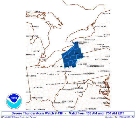
Initial List of Counties in SPC Severe Thunderstorm Watch 438 (WOU)
|
Back to Watch 438
|
 |
   WOUS64 KWNS 080548
   WOU8

   BULLETIN - IMMEDIATE BROADCAST REQUESTED
   SEVERE THUNDERSTORM WATCH OUTLINE UPDATE FOR WS 438
   NWS STORM PREDICTION CENTER NORMAN OK
   155 AM EDT WED JUN 8 2011

   SEVERE THUNDERSTORM WATCH 438 IS IN EFFECT UNTIL 700 AM EDT
   FOR THE FOLLOWING LOCATIONS

   NYC009-013-029-081100-
   /O.NEW.KWNS.SV.A.0438.110608T0555Z-110608T1100Z/

   NY
   .    NEW YORK COUNTIES INCLUDED ARE

   CATTARAUGUS          CHAUTAUQUA          ERIE


   PAC031-039-049-053-083-085-121-123-081100-
   /O.NEW.KWNS.SV.A.0438.110608T0555Z-110608T1100Z/

   PA
   .    PENNSYLVANIA COUNTIES INCLUDED ARE

   CLARION              CRAWFORD            ERIE
   FOREST               MCKEAN              MERCER
   VENANGO              WARREN


   LEZ040-041-061-149-169-081100-
   /O.NEW.KWNS.SV.A.0438.110608T0555Z-110608T1100Z/

   CW

   .    ADJACENT COASTAL WATERS INCLUDED ARE

   RIPLEY TO DUNKIRK NY

   DUNKIRK TO BUFFALO NY

   RIPLEY TO BUFFALO NY EXTENDING FROM 5NM OFF SHORELINE TO
   US-CANADIAN BORDER

   CONNEAUT OH TO RIPLEY NY

   CONNEAUT OH TO RIPLEY NY BEYOND 5 NM OFF SHORELINE TO US-CANADIAN
   BORDER

   ATTN...WFO...BUF...CLE...CTP...PBZ...
|
| Aviation Watch (SAW) for WW438 |
|---|
 |
| Note:
The Aviation Watch (SAW) product is an approximation to the watch area.
The actual watch is depicted by the shaded areas. |
   SAW8
   WW 438 SEVERE TSTM NY PA LE 080555Z - 081100Z
   AXIS..50 STATUTE MILES NORTH AND SOUTH OF LINE..
   30WNW FKL/FRANKLIN PA/ - 30E JHW/JAMESTOWN NY/
   ..AVIATION COORDS.. 45NM N/S /29S ERI - 20E JHW/
   HAIL SURFACE AND ALOFT..2 INCHES. WIND GUSTS..60 KNOTS.
   MAX TOPS TO 500. MEAN STORM MOTION VECTOR 33030.

   LAT...LON 42278041 42867866 41417866 40818041

   THIS IS AN APPROXIMATION TO THE WATCH AREA.  FOR A
   COMPLETE DEPICTION OF THE WATCH SEE WOUS64 KWNS
   FOR WOU8.
|
|


 @NWSSPC
