|
Initial List of Counties in SPC Severe Thunderstorm Watch 688 (WOU)
|
Back to Watch 688
|
 |
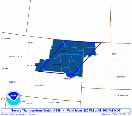
   WOUS64 KWNS 262014
   WOU8

   BULLETIN - IMMEDIATE BROADCAST REQUESTED
   SEVERE THUNDERSTORM WATCH OUTLINE UPDATE FOR WS 688
   NWS STORM PREDICTION CENTER NORMAN OK
   220 PM MDT TUE JUL 26 2011

   SEVERE THUNDERSTORM WATCH 688 IS IN EFFECT UNTIL 900 PM MDT
   FOR THE FOLLOWING LOCATIONS

   MTC019-021-033-055-069-079-083-085-091-105-109-270300-
   /O.NEW.KWNS.SV.A.0688.110726T2020Z-110727T0300Z/

   MT
   .    MONTANA COUNTIES INCLUDED ARE

   DANIELS              DAWSON              GARFIELD
   MCCONE               PETROLEUM           PRAIRIE
   RICHLAND             ROOSEVELT           SHERIDAN
   VALLEY               WIBAUX


   NDC023-105-270300-
   /O.NEW.KWNS.SV.A.0688.110726T2020Z-110727T0300Z/

   ND
   .    NORTH DAKOTA COUNTIES INCLUDED ARE

   DIVIDE               WILLIAMS


   ATTN...WFO...GGW...BIS...
|
| Aviation Watch (SAW) for WW688 |
|---|
 |
| Note:
The Aviation Watch (SAW) product is an approximation to the watch area.
The actual watch is depicted by the shaded areas. |
   SAW8
   WW 688 SEVERE TSTM MT ND 262020Z - 270300Z
   AXIS..80 STATUTE MILES EAST AND WEST OF LINE..
   60NNW ISN/WILLISTON ND/ - 100S GGW/GLASGOW MT/
   ..AVIATION COORDS.. 70NM E/W /52NNW ISN - 36NW MLS/
   HAIL SURFACE AND ALOFT..2 INCHES. WIND GUSTS..60 KNOTS.
   MAX TOPS TO 500. MEAN STORM MOTION VECTOR 25030.

   LAT...LON 48970237 46750493 46750830 48970590

   THIS IS AN APPROXIMATION TO THE WATCH AREA.  FOR A
   COMPLETE DEPICTION OF THE WATCH SEE WOUS64 KWNS
   FOR WOU8.
|
|


 @NWSSPC
