|
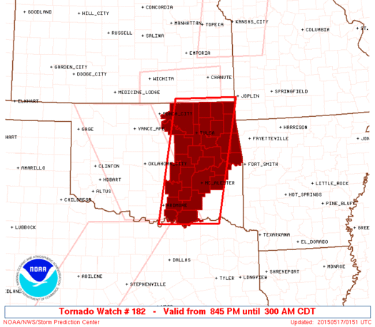
Initial List of Counties in SPC Tornado Watch 182 (WOU)
|
Back to Watch 182
|
 |
   WOUS64 KWNS 170140
   WOU2

   BULLETIN - IMMEDIATE BROADCAST REQUESTED
   TORNADO WATCH OUTLINE UPDATE FOR WT 182
   NWS STORM PREDICTION CENTER NORMAN OK
   845 PM CDT SAT MAY 16 2015

   TORNADO WATCH 182 IS IN EFFECT UNTIL 300 AM CDT FOR THE
    FOLLOWING LOCATIONS

   OKC001-005-013-021-029-035-037-041-061-063-069-077-091-095-097-
   101-105-107-111-113-115-117-121-123-131-133-135-143-145-147-
   170800-
   /O.NEW.KWNS.TO.A.0182.150517T0145Z-150517T0800Z/

   OK
   .    OKLAHOMA COUNTIES INCLUDED ARE

   ADAIR                ATOKA               BRYAN
   CHEROKEE             COAL                CRAIG
   CREEK                DELAWARE            HASKELL
   HUGHES               JOHNSTON            LATIMER
   MARSHALL             MAYES               MCINTOSH
   MUSKOGEE             NOWATA              OKFUSKEE
   OKMULGEE             OSAGE               OTTAWA
   PAWNEE               PITTSBURG           PONTOTOC
   ROGERS               SEMINOLE            SEQUOYAH
   TULSA                WAGONER             WASHINGTON


   ATTN...WFO...TSA...OUN...
|
| Aviation Watch (SAW) for WW182 |
|---|
 |
| Note:
The Aviation Watch (SAW) product is an approximation to the watch area.
The actual watch is depicted by the shaded areas. |
   SAW2
   WW 182 TORNADO OK 170145Z - 170800Z
   AXIS..55 STATUTE MILES EAST AND WEST OF LINE..
   35NE BVO/BARTLESVILLE OK/ - 15SE DUA/DURANT OK/
   ..AVIATION COORDS.. 50NM E/W /18W OSW - 54ESE ADM/
   HAIL SURFACE AND ALOFT..2 INCHES. WIND GUSTS..60 KNOTS.
   MAX TOPS TO 500. MEAN STORM MOTION VECTOR 24035.

   LAT...LON 37119456 33799526 33799716 37119656

   THIS IS AN APPROXIMATION TO THE WATCH AREA.  FOR A
   COMPLETE DEPICTION OF THE WATCH SEE WOUS64 KWNS
   FOR WOU2.
|
|


 @NWSSPC
