|
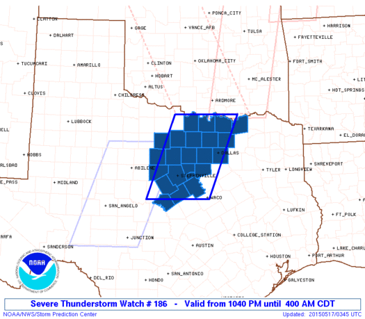
Initial List of Counties in SPC Severe Thunderstorm Watch 186 (WOU)
|
Back to Watch 186
|
 |
   WOUS64 KWNS 170338
   WOU6

   BULLETIN - IMMEDIATE BROADCAST REQUESTED
   SEVERE THUNDERSTORM WATCH OUTLINE UPDATE FOR WS 186
   NWS STORM PREDICTION CENTER NORMAN OK
   1040 PM CDT SAT MAY 16 2015

   SEVERE THUNDERSTORM WATCH 186 IS IN EFFECT UNTIL 400 AM CDT
   FOR THE FOLLOWING LOCATIONS

   TXC035-085-093-097-113-121-133-143-147-181-193-221-237-251-333-
   337-363-367-425-429-439-497-503-170900-
   /O.NEW.KWNS.SV.A.0186.150517T0340Z-150517T0900Z/

   TX
   .    TEXAS COUNTIES INCLUDED ARE

   BOSQUE               COLLIN              COMANCHE
   COOKE                DALLAS              DENTON
   EASTLAND             ERATH               FANNIN
   GRAYSON              HAMILTON            HOOD
   JACK                 JOHNSON             MILLS
   MONTAGUE             PALO PINTO          PARKER
   SOMERVELL            STEPHENS            TARRANT
   WISE                 YOUNG


   ATTN...WFO...FWD...
|
| Aviation Watch (SAW) for WW186 |
|---|
 |
| Note:
The Aviation Watch (SAW) product is an approximation to the watch area.
The actual watch is depicted by the shaded areas. |
   SAW6
   WW 186 SEVERE TSTM TX 170340Z - 170900Z
   AXIS..60 STATUTE MILES EAST AND WEST OF LINE..
   35WNW GYI/SHERMAN TX/ - 45S SEP/STEPHENVILLE TX/
   ..AVIATION COORDS.. 50NM E/W /18S ADM - 47W ACT/
   HAIL SURFACE AND ALOFT..2 INCHES. WIND GUSTS..60 KNOTS.
   MAX TOPS TO 500. MEAN STORM MOTION VECTOR 25030.

   LAT...LON 33909619 31559716 31559919 33909827

   THIS IS AN APPROXIMATION TO THE WATCH AREA.  FOR A
   COMPLETE DEPICTION OF THE WATCH SEE WOUS64 KWNS
   FOR WOU6.
|
|


 @NWSSPC
