|
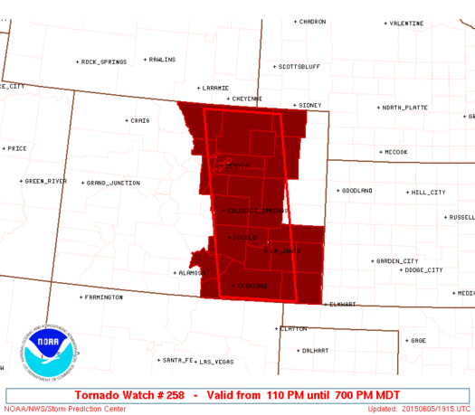
Initial List of Counties in SPC Tornado Watch 258 (WOU)
|
Back to Watch 258
|
 |
   WOUS64 KWNS 051906
   WOU8

   BULLETIN - IMMEDIATE BROADCAST REQUESTED
   TORNADO WATCH OUTLINE UPDATE FOR WT 258
   NWS STORM PREDICTION CENTER NORMAN OK
   110 PM MDT FRI JUN 5 2015

   TORNADO WATCH 258 IS IN EFFECT UNTIL 700 PM MDT FOR THE
    FOLLOWING LOCATIONS

   COC001-005-009-011-013-014-025-031-035-039-041-055-059-061-069-
   071-073-075-087-089-099-101-121-123-060100-
   /O.NEW.KWNS.TO.A.0258.150605T1910Z-150606T0100Z/

   CO
   .    COLORADO COUNTIES INCLUDED ARE

   ADAMS                ARAPAHOE            BACA
   BENT                 BOULDER             BROOMFIELD
   CROWLEY              DENVER              DOUGLAS
   ELBERT               EL PASO             HUERFANO
   JEFFERSON            KIOWA               LARIMER
   LAS ANIMAS           LINCOLN             LOGAN
   MORGAN               OTERO               PROWERS
   PUEBLO               WASHINGTON          WELD


   ATTN...WFO...BOU...PUB...
|
| Aviation Watch (SAW) for WW258 |
|---|
 |
| Note:
The Aviation Watch (SAW) product is an approximation to the watch area.
The actual watch is depicted by the shaded areas. |
   SAW8
   WW 258 TORNADO CO 051910Z - 060100Z
   AXIS..55 STATUTE MILES EAST AND WEST OF LINE..
   45NE FCL/FORT COLLINS CO/ - 40ESE TAD/TRINIDAD CO/
   ..AVIATION COORDS.. 50NM E/W /24SE CYS - 14SSW TBE/
   HAIL SURFACE AND ALOFT..2.5 INCHES. WIND GUSTS..60 KNOTS.
   MAX TOPS TO 500. MEAN STORM MOTION VECTOR 24030.

   LAT...LON 40900336 37040266 37040466 40900545

   THIS IS AN APPROXIMATION TO THE WATCH AREA.  FOR A
   COMPLETE DEPICTION OF THE WATCH SEE WOUS64 KWNS
   FOR WOU8.
|
|


 @NWSSPC
