|
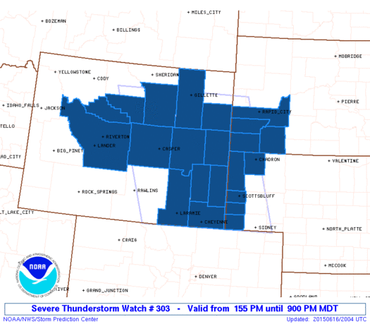
Initial List of Counties in SPC Severe Thunderstorm Watch 303 (WOU)
|
Back to Watch 303
|
 |
   WOUS64 KWNS 161957
   WOU3

   BULLETIN - IMMEDIATE BROADCAST REQUESTED
   SEVERE THUNDERSTORM WATCH OUTLINE UPDATE FOR WS 303
   NWS STORM PREDICTION CENTER NORMAN OK
   155 PM MDT TUE JUN 16 2015

   SEVERE THUNDERSTORM WATCH 303 IS IN EFFECT UNTIL 900 PM MDT
   FOR THE FOLLOWING LOCATIONS

   NEC007-045-105-157-165-170300-
   /O.NEW.KWNS.SV.A.0303.150616T1955Z-150617T0300Z/

   NE
   .    NEBRASKA COUNTIES INCLUDED ARE

   BANNER               DAWES               KIMBALL
   SCOTTS BLUFF         SIOUX


   SDC033-047-103-113-170300-
   /O.NEW.KWNS.SV.A.0303.150616T1955Z-150617T0300Z/

   SD
   .    SOUTH DAKOTA COUNTIES INCLUDED ARE

   CUSTER               FALL RIVER          PENNINGTON
   SHANNON


   WYC001-005-009-013-015-017-019-021-025-027-031-043-045-170300-
   /O.NEW.KWNS.SV.A.0303.150616T1955Z-150617T0300Z/

   WY
   .    WYOMING COUNTIES INCLUDED ARE

   ALBANY               CAMPBELL            CONVERSE
   FREMONT              GOSHEN              HOT SPRINGS
   JOHNSON              LARAMIE             NATRONA
   NIOBRARA             PLATTE              WASHAKIE
   WESTON


   ATTN...WFO...CYS...UNR...RIW...
|
| Aviation Watch (SAW) for WW303 |
|---|
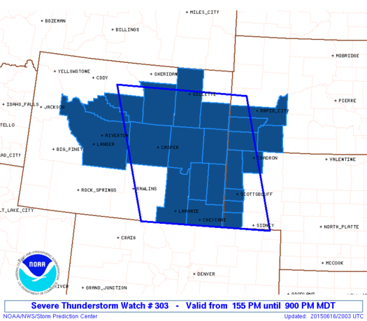 |
| Note:
The Aviation Watch (SAW) product is an approximation to the watch area.
The actual watch is depicted by the shaded areas. |
   SAW3
   WW 303 SEVERE TSTM NE SD WY 161955Z - 170300Z
   AXIS..115 STATUTE MILES EAST AND WEST OF LINE..
   15WNW GCC/GILLETTE WY/ - 15SE CYS/CHEYENNE WY/
   ..AVIATION COORDS.. 100NM E/W /38NE CZI - 15SSE CYS/
   HAIL SURFACE AND ALOFT..2.5 INCHES. WIND GUSTS..60 KNOTS.
   MAX TOPS TO 550. MEAN STORM MOTION VECTOR 30030.

   LAT...LON 44400348 40970241 40970681 44400813

   THIS IS AN APPROXIMATION TO THE WATCH AREA.  FOR A
   COMPLETE DEPICTION OF THE WATCH SEE WOUS64 KWNS
   FOR WOU3.
|
|


 @NWSSPC
