|
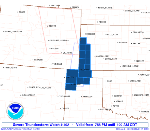
Initial List of Counties in SPC Severe Thunderstorm Watch 492 (WOU)
|
Back to Watch 492
|
 |
   WOUS64 KWNS 180050
   WOU2

   BULLETIN - IMMEDIATE BROADCAST REQUESTED
   SEVERE THUNDERSTORM WATCH OUTLINE UPDATE FOR WS 492
   NWS STORM PREDICTION CENTER NORMAN OK
   755 PM CDT MON AUG 17 2015

   SEVERE THUNDERSTORM WATCH 492 IS IN EFFECT UNTIL 100 AM CDT
   FOR THE FOLLOWING LOCATIONS

   KSC067-071-075-093-129-187-189-199-203-180600-
   /O.NEW.KWNS.SV.A.0492.150818T0055Z-150818T0600Z/

   KS
   .    KANSAS COUNTIES INCLUDED ARE

   GRANT                GREELEY             HAMILTON
   KEARNY               MORTON              STANTON
   STEVENS              WALLACE             WICHITA


   OKC025-139-180600-
   /O.NEW.KWNS.SV.A.0492.150818T0055Z-150818T0600Z/

   OK
   .    OKLAHOMA COUNTIES INCLUDED ARE

   CIMARRON             TEXAS


   TXC111-195-205-421-180600-
   /O.NEW.KWNS.SV.A.0492.150818T0055Z-150818T0600Z/

   TX
   .    TEXAS COUNTIES INCLUDED ARE

   DALLAM               HANSFORD            HARTLEY
   SHERMAN


   ATTN...WFO...DDC...AMA...GLD...
|
| Aviation Watch (SAW) for WW492 |
|---|
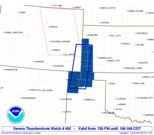 |
| Note:
The Aviation Watch (SAW) product is an approximation to the watch area.
The actual watch is depicted by the shaded areas. |
   SAW2
   WW 492 SEVERE TSTM KS OK TX 180055Z - 180600Z
   AXIS..35 STATUTE MILES EAST AND WEST OF LINE..
   110NNE SPD/SPRINGFIELD CO/ - 20ESE DHT/DALHART TX/
   ..AVIATION COORDS.. 30NM E/W /39S GLD - 47NW AMA/
   HAIL SURFACE AND ALOFT..2 INCHES. WIND GUSTS..60 KNOTS.
   MAX TOPS TO 500. MEAN STORM MOTION VECTOR 29025.

   LAT...LON 38750119 35900158 35900284 38750248

   THIS IS AN APPROXIMATION TO THE WATCH AREA.  FOR A
   COMPLETE DEPICTION OF THE WATCH SEE WOUS64 KWNS
   FOR WOU2.
|
|


 @NWSSPC
