 Note:
The expiration time in the watch graphic is amended if the watch is
replaced, cancelled or extended.
Note:
Note:
The expiration time in the watch graphic is amended if the watch is
replaced, cancelled or extended.
Note: Click for
Watch Status Reports.
SEL8
URGENT - IMMEDIATE BROADCAST REQUESTED
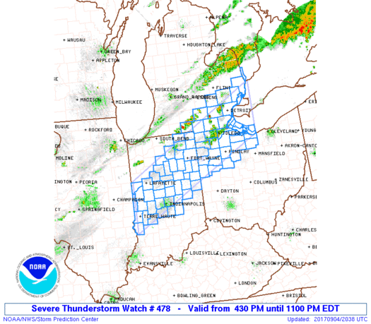
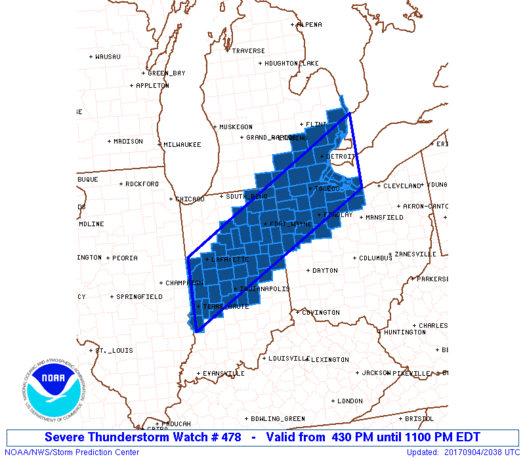
Severe Thunderstorm Watch Number 478
NWS Storm Prediction Center Norman OK
430 PM EDT Mon Sep 4 2017
The NWS Storm Prediction Center has issued a
* Severe Thunderstorm Watch for portions of
Central and northeastern Indiana
Southeastern Lower Michigan
Northwestern Ohio
Lake Erie
Lake Huron
* Effective this Monday afternoon and evening from 430 PM until
1100 PM EDT.
* Primary threats include...
Widespread damaging wind gusts to 70 mph likely
Isolated large hail events to 1.5 inches in diameter possible
SUMMARY...Thunderstorm development is expected in the next 1-2 hours
along a cold front moving southeastward across Lower Michigan and
northern Indiana. The storms should evolve rather quickly into a
line, and the storm environment will favor damaging winds with most
storms in the squall line through late evening.
The severe thunderstorm watch area is approximately along and 55
statute miles north and south of a line from 20 miles north
northwest of Terre Haute IN to 35 miles southeast of Mount Clemens
MI. For a complete depiction of the watch see the associated watch
outline update (WOUS64 KWNS WOU8).
PRECAUTIONARY/PREPAREDNESS ACTIONS...
REMEMBER...A Severe Thunderstorm Watch means conditions are
favorable for severe thunderstorms in and close to the watch area.
Persons in these areas should be on the lookout for threatening
weather conditions and listen for later statements and possible
warnings. Severe thunderstorms can and occasionally do produce
tornadoes.
&&
AVIATION...A few severe thunderstorms with hail surface and aloft to
1.5 inches. Extreme turbulence and surface wind gusts to 60 knots. A
few cumulonimbi with maximum tops to 500. Mean storm motion vector
29040.
...Thompson
   SEL8

   URGENT - IMMEDIATE BROADCAST REQUESTED
   Severe Thunderstorm Watch Number 478
   NWS Storm Prediction Center Norman OK
   430 PM EDT Mon Sep 4 2017

   The NWS Storm Prediction Center has issued a

   * Severe Thunderstorm Watch for portions of
     Central and northeastern Indiana
     Southeastern Lower Michigan
     Northwestern Ohio
     Lake Erie
     Lake Huron

   * Effective this Monday afternoon and evening from 430 PM until
     1100 PM EDT.

   * Primary threats include...
     Widespread damaging wind gusts to 70 mph likely
     Isolated large hail events to 1.5 inches in diameter possible

   SUMMARY...Thunderstorm development is expected in the next 1-2 hours
   along a cold front moving southeastward across Lower Michigan and
   northern Indiana.  The storms should evolve rather quickly into a
   line, and the storm environment will favor damaging winds with most
   storms in the squall line through late evening.

   The severe thunderstorm watch area is approximately along and 55
   statute miles north and south of a line from 20 miles north
   northwest of Terre Haute IN to 35 miles southeast of Mount Clemens
   MI. For a complete depiction of the watch see the associated watch
   outline update (WOUS64 KWNS WOU8).

   PRECAUTIONARY/PREPAREDNESS ACTIONS...

   REMEMBER...A Severe Thunderstorm Watch means conditions are
   favorable for severe thunderstorms in and close to the watch area.
   Persons in these areas should be on the lookout for threatening
   weather conditions and listen for later statements and possible
   warnings. Severe thunderstorms can and occasionally do produce
   tornadoes.

   &&

   AVIATION...A few severe thunderstorms with hail surface and aloft to
   1.5 inches. Extreme turbulence and surface wind gusts to 60 knots. A
   few cumulonimbi with maximum tops to 500. Mean storm motion vector
   29040.

   ...Thompson
 Note:
The Aviation Watch (SAW) product is an approximation to the watch area.
The actual watch is depicted by the shaded areas.
Note:
The Aviation Watch (SAW) product is an approximation to the watch area.
The actual watch is depicted by the shaded areas.
   SAW8
   WW 478 SEVERE TSTM IN MI OH LE LH 042030Z - 050300Z
   AXIS..55 STATUTE MILES NORTH AND SOUTH OF LINE..
   20NNW HUF/TERRE HAUTE IN/ - 35SE MTC/MOUNT CLEMENS MI/
   ..AVIATION COORDS.. 50NM N/S /17NW TTH - 46E DXO/
   HAIL SURFACE AND ALOFT..1.5 INCHES. WIND GUSTS..60 KNOTS.
   MAX TOPS TO 500. MEAN STORM MOTION VECTOR 29040.

   LAT...LON 40508745 43048234 41438234 38918745

   THIS IS AN APPROXIMATION TO THE WATCH AREA.  FOR A
   COMPLETE DEPICTION OF THE WATCH SEE WOUS64 KWNS
   FOR WOU8.
Watch 478 Status Report Message has not been issued yet.
Note:
Click for Complete Product Text.
Tornadoes
Probability of 2 or more tornadoes
|
Low (10%)
|
Probability of 1 or more strong (F2-F5) tornadoes
|
Low (<2%)
|
Wind
Probability of 10 or more severe wind events
|
High (80%)
|
Probability of 1 or more wind events > 65 knots
|
Low (20%)
|
Hail
Probability of 10 or more severe hail events
|
Mod (30%)
|
Probability of 1 or more hailstones > 2 inches
|
Low (10%)
|
Combined Severe Hail/Wind
Probability of 6 or more combined severe hail/wind events
|
High (>95%)
|
For each watch, probabilities for particular events inside the watch
(listed above in each table) are determined by the issuing forecaster.
The "Low" category contains probability values ranging from less than 2%
to 20% (F2-F5 tornadoes), less than 5% to 20% (all other probabilities),
"Moderate" from 30% to 60%, and "High" from 70% to greater than 95%.
High values are bolded and lighter in color to provide awareness of
an increased threat for a particular event.


 @NWSSPC


