|
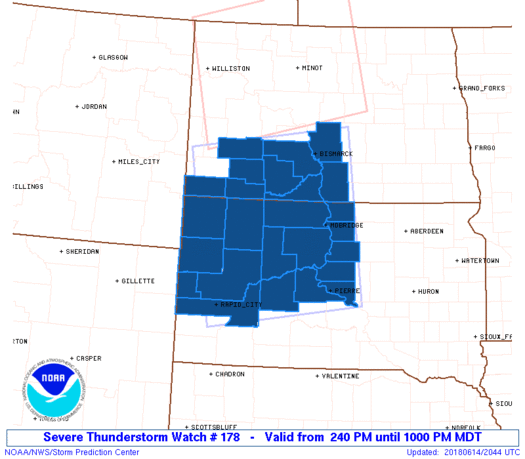
Initial List of Counties in SPC Severe Thunderstorm Watch 178 (WOU)
|
Back to Watch 178
|
 |
   WOUS64 KWNS 142036
   WOU8

   BULLETIN - IMMEDIATE BROADCAST REQUESTED
   SEVERE THUNDERSTORM WATCH OUTLINE UPDATE FOR WS 178
   NWS STORM PREDICTION CENTER NORMAN OK
   240 PM MDT THU JUN 14 2018

   SEVERE THUNDERSTORM WATCH 178 IS IN EFFECT UNTIL 1000 PM MDT
   FOR THE FOLLOWING LOCATIONS

   NDC001-011-015-029-037-041-059-085-089-150400-
   /O.NEW.KWNS.SV.A.0178.180614T2040Z-180615T0400Z/

   ND
   .    NORTH DAKOTA COUNTIES INCLUDED ARE

   ADAMS                BOWMAN              BURLEIGH
   EMMONS               GRANT               HETTINGER
   MORTON               SIOUX               STARK


   SDC019-021-031-041-055-063-065-081-093-103-105-107-117-119-129-
   137-150400-
   /O.NEW.KWNS.SV.A.0178.180614T2040Z-180615T0400Z/

   SD
   .    SOUTH DAKOTA COUNTIES INCLUDED ARE

   BUTTE                CAMPBELL            CORSON
   DEWEY                HAAKON              HARDING
   HUGHES               LAWRENCE            MEADE
   PENNINGTON           PERKINS             POTTER
   STANLEY              SULLY               WALWORTH
   ZIEBACH


   ATTN...WFO...BIS...UNR...ABR...
|
| Aviation Watch (SAW) for WW178 |
|---|
 |
| Note:
The Aviation Watch (SAW) product is an approximation to the watch area.
The actual watch is depicted by the shaded areas. |
   SAW8
   WW 178 SEVERE TSTM ND SD 142040Z - 150400Z
   AXIS..95 STATUTE MILES EITHER SIDE OF LINE..
   45ENE DIK/DICKINSON ND/ - 15SE PHP/PHILIP SD/
   ..AVIATION COORDS.. 85NM EITHER SIDE /37ENE DIK - 61WSW PIR/
   HAIL SURFACE AND ALOFT..2.5 INCHES. WIND GUSTS..75 KNOTS.
   MAX TOPS TO 550. MEAN STORM MOTION VECTOR 25040.

   LAT...LON 47259991 44119950 43650326 46790390

   THIS IS AN APPROXIMATION TO THE WATCH AREA.  FOR A
   COMPLETE DEPICTION OF THE WATCH SEE WOUS64 KWNS
   FOR WOU8.
|
|


 @NWSSPC
