|
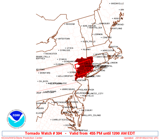
Initial List of Counties in SPC Tornado Watch 394 (WOU)
|
Back to Watch 394
|
 |
   WOUS64 KWNS 022054
   WOU4

   BULLETIN - IMMEDIATE BROADCAST REQUESTED
   TORNADO WATCH OUTLINE UPDATE FOR WT 394
   NWS STORM PREDICTION CENTER NORMAN OK
   455 PM EDT TUE OCT 2 2018

   TORNADO WATCH 394 IS IN EFFECT UNTIL 1200 AM EDT FOR THE
    FOLLOWING LOCATIONS

   CTC001-005-030400-
   /O.NEW.KWNS.TO.A.0394.181002T2055Z-181003T0400Z/

   CT
   .    CONNECTICUT COUNTIES INCLUDED ARE

   FAIRFIELD            LITCHFIELD


   NJC003-013-027-031-037-041-030400-
   /O.NEW.KWNS.TO.A.0394.181002T2055Z-181003T0400Z/

   NJ
   .    NEW JERSEY COUNTIES INCLUDED ARE

   BERGEN               ESSEX               MORRIS
   PASSAIC              SUSSEX              WARREN


   NYC027-071-079-087-111-119-030400-
   /O.NEW.KWNS.TO.A.0394.181002T2055Z-181003T0400Z/

   NY
   .    NEW YORK COUNTIES INCLUDED ARE

   DUTCHESS             ORANGE              PUTNAM
   ROCKLAND             ULSTER              WESTCHESTER


   ATTN...WFO...OKX...ALY...PHI...
|
| Aviation Watch (SAW) for WW394 |
|---|
 |
| Note:
The Aviation Watch (SAW) product is an approximation to the watch area.
The actual watch is depicted by the shaded areas. |
   SAW4
   WW 394 TORNADO CT NJ NY 022055Z - 030400Z
   AXIS..30 STATUTE MILES NORTH AND SOUTH OF LINE..
   55WSW POU/POUGHKEEPSIE NY/ - 35ESE POU/POUGHKEEPSIE NY/
   ..AVIATION COORDS.. 25NM N/S /21NW SAX - 40SW BDL/
   HAIL SURFACE AND ALOFT..1.5 INCHES. WIND GUSTS..60 KNOTS.
   MAX TOPS TO 500. MEAN STORM MOTION VECTOR 27025.

   LAT...LON 41757486 41867326 41007326 40887486

   THIS IS AN APPROXIMATION TO THE WATCH AREA.  FOR A
   COMPLETE DEPICTION OF THE WATCH SEE WOUS64 KWNS
   FOR WOU4.
|
|


 @NWSSPC
