 Note:
The expiration time in the watch graphic is amended if the watch is
replaced, cancelled or extended.
Note:
Note:
The expiration time in the watch graphic is amended if the watch is
replaced, cancelled or extended.
Note: Click for
Watch Status Reports.
SEL9
URGENT - IMMEDIATE BROADCAST REQUESTED
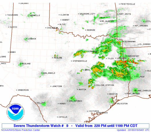
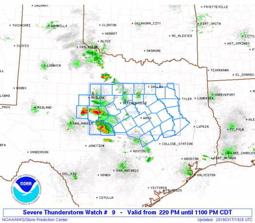
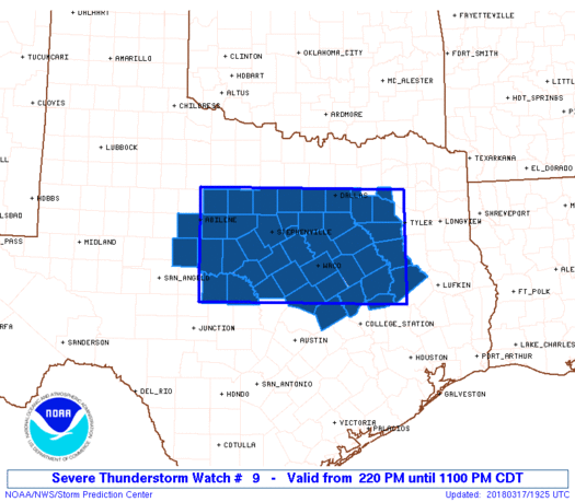
Severe Thunderstorm Watch Number 9
NWS Storm Prediction Center Norman OK
220 PM CDT Sat Mar 17 2018
The NWS Storm Prediction Center has issued a
* Severe Thunderstorm Watch for portions of
North-central and Northeast Texas
* Effective this Saturday afternoon and evening from 220 PM until
1100 PM CDT.
* Primary threats include...
Scattered large hail likely with isolated very large hail events
to 3 inches in diameter possible
Isolated damaging wind gusts to 70 mph possible
A tornado or two possible
SUMMARY...Strong to severe thunderstorms will continue to increase
this afternoon, initially across the North-central Texas Big Country
and then spreading generally eastward toward parts of east/northeast
Texas through early evening. Large hail will be the most common
hazard. Damaging wind potential could somewhat increase later this
afternoon into evening if a semi-organized storm cluster evolves.
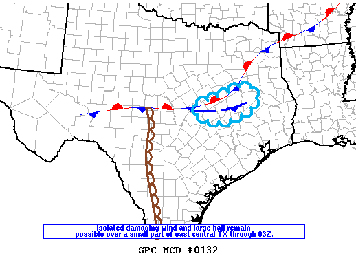
The severe thunderstorm watch area is approximately along and 70
statute miles north and south of a line from 30 miles south of
Abilene TX to 30 miles south of Tyler TX. For a complete depiction
of the watch see the associated watch outline update (WOUS64 KWNS
WOU9).
PRECAUTIONARY/PREPAREDNESS ACTIONS...
REMEMBER...A Severe Thunderstorm Watch means conditions are
favorable for severe thunderstorms in and close to the watch area.
Persons in these areas should be on the lookout for threatening
weather conditions and listen for later statements and possible
warnings. Severe thunderstorms can and occasionally do produce
tornadoes.
&&
AVIATION...A few severe thunderstorms with hail surface and aloft to
3 inches. Extreme turbulence and surface wind gusts to 60 knots. A
few cumulonimbi with maximum tops to 450. Mean storm motion vector
24025.
...Guyer
   SEL9

   URGENT - IMMEDIATE BROADCAST REQUESTED
   Severe Thunderstorm Watch Number 9
   NWS Storm Prediction Center Norman OK
   220 PM CDT Sat Mar 17 2018

   The NWS Storm Prediction Center has issued a

   * Severe Thunderstorm Watch for portions of
     North-central and Northeast Texas

   * Effective this Saturday afternoon and evening from 220 PM until
     1100 PM CDT.

   * Primary threats include...
     Scattered large hail likely with isolated very large hail events
       to 3 inches in diameter possible
     Isolated damaging wind gusts to 70 mph possible
     A tornado or two possible

   SUMMARY...Strong to severe thunderstorms will continue to increase
   this afternoon, initially across the North-central Texas Big Country
   and then spreading generally eastward toward parts of east/northeast
   Texas through early evening. Large hail will be the most common
   hazard. Damaging wind potential could somewhat increase later this
   afternoon into evening if a semi-organized storm cluster evolves.

   The severe thunderstorm watch area is approximately along and 70
   statute miles north and south of a line from 30 miles south of
   Abilene TX to 30 miles south of Tyler TX. For a complete depiction
   of the watch see the associated watch outline update (WOUS64 KWNS
   WOU9).

   PRECAUTIONARY/PREPAREDNESS ACTIONS...

   REMEMBER...A Severe Thunderstorm Watch means conditions are
   favorable for severe thunderstorms in and close to the watch area.
   Persons in these areas should be on the lookout for threatening
   weather conditions and listen for later statements and possible
   warnings. Severe thunderstorms can and occasionally do produce
   tornadoes.

   &&

   AVIATION...A few severe thunderstorms with hail surface and aloft to
   3 inches. Extreme turbulence and surface wind gusts to 60 knots. A
   few cumulonimbi with maximum tops to 450. Mean storm motion vector
   24025.

   ...Guyer
 Note:
The Aviation Watch (SAW) product is an approximation to the watch area.
The actual watch is depicted by the shaded areas.
Note:
The Aviation Watch (SAW) product is an approximation to the watch area.
The actual watch is depicted by the shaded areas.
   SAW9
   WW 9 SEVERE TSTM TX 171920Z - 180400Z
   AXIS..70 STATUTE MILES NORTH AND SOUTH OF LINE..
   30S ABI/ABILENE TX/ - 30S TYR/TYLER TX/
   ..AVIATION COORDS.. 60NM N/S /31SSE ABI - 45SW GGG/
   HAIL SURFACE AND ALOFT..3 INCHES. WIND GUSTS..60 KNOTS.
   MAX TOPS TO 450. MEAN STORM MOTION VECTOR 24025.

   LAT...LON 33009968 32939540 30899540 30969968

   THIS IS AN APPROXIMATION TO THE WATCH AREA.  FOR A
   COMPLETE DEPICTION OF THE WATCH SEE WOUS64 KWNS
   FOR WOU9.
Watch 9 Status Report Messages:
STATUS REPORT #7 ON WW 9

VALID 180340Z - 180400Z

SEVERE WEATHER THREAT CONTINUES RIGHT OF A LINE FROM 25 NNE CLL
TO 30 NW UTS TO 15 N UTS.

WW 9 WILL BE ALLOWED TO EXPIRE AT 180400Z AS STORMS CONTINUE TO
WEAKEN.
..DIAL..03/18/18

ATTN...WFO...FWD...SJT...HGX...

&&

STATUS REPORT FOR WS 9

SEVERE WEATHER THREAT CONTINUES FOR THE FOLLOWING AREAS

TXC313-180400-

TX
.    TEXAS COUNTIES INCLUDED ARE

MADISON
$$


THE WATCH STATUS MESSAGE IS FOR GUIDANCE PURPOSES ONLY.  PLEASE
REFER TO WATCH COUNTY NOTIFICATION STATEMENTS FOR OFFICIAL
INFORMATION ON COUNTIES...INDEPENDENT CITIES AND MARINE ZONES
CLEARED FROM SEVERE THUNDERSTORM AND TORNADO WATCHES.
$$

STATUS REPORT #6 ON WW 9

VALID 180230Z - 180340Z

SEVERE WEATHER THREAT CONTINUES RIGHT OF A LINE FROM 15 SSE TPL
TO 20 SE ACT TO 45 WNW LFK.

FOR ADDITIONAL INFORMATION SEE MESOSCALE DISCUSSION 132

..DIAL..03/18/18

ATTN...WFO...FWD...SJT...HGX...

&&

STATUS REPORT FOR WS 9

SEVERE WEATHER THREAT CONTINUES FOR THE FOLLOWING AREAS

TXC145-225-289-293-313-331-395-180340-

TX
.    TEXAS COUNTIES INCLUDED ARE

FALLS		     HOUSTON		 LEON
LIMESTONE	     MADISON		 MILAM
ROBERTSON
$$


THE WATCH STATUS MESSAGE IS FOR GUIDANCE PURPOSES ONLY.  PLEASE
REFER TO WATCH COUNTY NOTIFICATION STATEMENTS FOR OFFICIAL
INFORMATION ON COUNTIES...INDEPENDENT CITIES AND MARINE ZONES
CLEARED FROM SEVERE THUNDERSTORM AND TORNADO WATCHES.
$$

STATUS REPORT #5 ON WW 9

VALID 180140Z - 180240Z

SEVERE WEATHER THREAT CONTINUES RIGHT OF A LINE FROM 20 WSW TPL
TO 5 SSW ACT TO 35 SSE CRS TO 45 NW LFK.

FOR ADDITIONAL INFORMATION SEE MESOSCALE DISCUSSION 132

..DIAL..03/18/18

ATTN...WFO...FWD...SJT...HGX...

&&

STATUS REPORT FOR WS 9

SEVERE WEATHER THREAT CONTINUES FOR THE FOLLOWING AREAS

TXC027-145-161-225-289-293-309-313-331-395-180240-

TX
.    TEXAS COUNTIES INCLUDED ARE

BELL		     FALLS		 FREESTONE
HOUSTON 	     LEON		 LIMESTONE
MCLENNAN	     MADISON		 MILAM
ROBERTSON
$$


THE WATCH STATUS MESSAGE IS FOR GUIDANCE PURPOSES ONLY.  PLEASE
REFER TO WATCH COUNTY NOTIFICATION STATEMENTS FOR OFFICIAL
INFORMATION ON COUNTIES...INDEPENDENT CITIES AND MARINE ZONES
CLEARED FROM SEVERE THUNDERSTORM AND TORNADO WATCHES.
$$

STATUS REPORT #4 ON WW 9

VALID 180040Z - 180140Z

SEVERE WEATHER THREAT CONTINUES RIGHT OF A LINE FROM 55 W TPL TO
40 SSE SEP TO 20 NE ACT TO 35 ESE ACT TO 35 S TYR.

..DIAL..03/18/18

ATTN...WFO...FWD...SJT...HGX...

&&

STATUS REPORT FOR WS 9

SEVERE WEATHER THREAT CONTINUES FOR THE FOLLOWING AREAS

TXC001-027-099-145-161-225-281-289-293-309-313-331-395-180140-

TX
.    TEXAS COUNTIES INCLUDED ARE

ANDERSON	     BELL		 CORYELL
FALLS		     FREESTONE		 HOUSTON
LAMPASAS	     LEON		 LIMESTONE
MCLENNAN	     MADISON		 MILAM
ROBERTSON
$$


THE WATCH STATUS MESSAGE IS FOR GUIDANCE PURPOSES ONLY.  PLEASE
REFER TO WATCH COUNTY NOTIFICATION STATEMENTS FOR OFFICIAL
INFORMATION ON COUNTIES...INDEPENDENT CITIES AND MARINE ZONES
CLEARED FROM SEVERE THUNDERSTORM AND TORNADO WATCHES.
$$

STATUS REPORT #3 ON WW 9

VALID 172340Z - 180040Z

SEVERE WEATHER THREAT CONTINUES RIGHT OF A LINE FROM 35 NNE JCT
TO 30 SW BWD TO 30 NW ACT TO 25 S DAL TO 40 NNE CRS TO 15 N TYR.

FOR ADDITIONAL INFORMATION SEE MESOSCALE DISCUSSION 129

..DIAL..03/17/18

ATTN...WFO...FWD...SJT...HGX...

&&

STATUS REPORT FOR WS 9

SEVERE WEATHER THREAT CONTINUES FOR THE FOLLOWING AREAS

TXC001-027-035-099-139-145-161-193-213-217-225-257-281-289-293-
307-309-313-331-333-349-395-411-467-180040-

TX
.    TEXAS COUNTIES INCLUDED ARE

ANDERSON	     BELL		 BOSQUE
CORYELL 	     ELLIS		 FALLS
FREESTONE	     HAMILTON		 HENDERSON
HILL		     HOUSTON		 KAUFMAN
LAMPASAS	     LEON		 LIMESTONE
MCCULLOCH	     MCLENNAN		 MADISON
MILAM		     MILLS		 NAVARRO
ROBERTSON	     SAN SABA		 VAN ZANDT
$$


THE WATCH STATUS MESSAGE IS FOR GUIDANCE PURPOSES ONLY.  PLEASE
REFER TO WATCH COUNTY NOTIFICATION STATEMENTS FOR OFFICIAL
INFORMATION ON COUNTIES...INDEPENDENT CITIES AND MARINE ZONES
CLEARED FROM SEVERE THUNDERSTORM AND TORNADO WATCHES.
$$

STATUS REPORT #2 ON WW 9

VALID 172230Z - 172340Z

SEVERE WEATHER THREAT CONTINUES RIGHT OF A LINE FROM 40 WSW BWD
TO 15 WNW BWD TO 15 SSW SEP TO 25 E SEP TO 10 NW DAL.

FOR ADDITIONAL INFORMATION SEE MESOSCALE DISCUSSION 129

..DIAL..03/17/18

ATTN...WFO...FWD...SJT...HGX...

&&

STATUS REPORT FOR WS 9

SEVERE WEATHER THREAT CONTINUES FOR THE FOLLOWING AREAS

TXC001-027-035-049-083-093-099-113-139-145-161-193-213-217-221-
225-251-257-281-289-293-307-309-313-331-333-349-379-395-397-411-
425-439-467-172340-

TX
.    TEXAS COUNTIES INCLUDED ARE

ANDERSON	     BELL		 BOSQUE
BROWN		     COLEMAN		 COMANCHE
CORYELL 	     DALLAS		 ELLIS
FALLS		     FREESTONE		 HAMILTON
HENDERSON	     HILL		 HOOD
HOUSTON 	     JOHNSON		 KAUFMAN
LAMPASAS	     LEON		 LIMESTONE
MCCULLOCH	     MCLENNAN		 MADISON
MILAM		     MILLS		 NAVARRO
RAINS		     ROBERTSON		 ROCKWALL
SAN SABA	     SOMERVELL		 TARRANT
VAN ZANDT
$$


THE WATCH STATUS MESSAGE IS FOR GUIDANCE PURPOSES ONLY.  PLEASE
REFER TO WATCH COUNTY NOTIFICATION STATEMENTS FOR OFFICIAL
INFORMATION ON COUNTIES...INDEPENDENT CITIES AND MARINE ZONES
CLEARED FROM SEVERE THUNDERSTORM AND TORNADO WATCHES.
$$

STATUS REPORT #1 ON WW 9

VALID 172025Z - 172140Z

THE SEVERE WEATHER THREAT CONTINUES ACROSS THE ENTIRE WATCH AREA.

..GOSS..03/17/18

ATTN...WFO...FWD...SJT...HGX...

&&

STATUS REPORT FOR WS 9

SEVERE WEATHER THREAT CONTINUES FOR THE FOLLOWING AREAS

TXC001-027-035-049-059-083-093-099-113-133-139-143-145-161-193-
213-217-221-225-251-257-281-289-293-307-309-313-331-333-349-363-
367-379-395-397-399-411-417-425-429-439-441-467-172140-

TX
.    TEXAS COUNTIES INCLUDED ARE

ANDERSON	     BELL		 BOSQUE
BROWN		     CALLAHAN		 COLEMAN
COMANCHE	     CORYELL		 DALLAS
EASTLAND	     ELLIS		 ERATH
FALLS		     FREESTONE		 HAMILTON
HENDERSON	     HILL		 HOOD
HOUSTON 	     JOHNSON		 KAUFMAN
LAMPASAS	     LEON		 LIMESTONE
MCCULLOCH	     MCLENNAN		 MADISON
MILAM		     MILLS		 NAVARRO
PALO PINTO	     PARKER		 RAINS
ROBERTSON	     ROCKWALL		 RUNNELS
SAN SABA	     SHACKELFORD	 SOMERVELL
STEPHENS	     TARRANT		 TAYLOR
VAN ZANDT
$$


THE WATCH STATUS MESSAGE IS FOR GUIDANCE PURPOSES ONLY.  PLEASE
REFER TO WATCH COUNTY NOTIFICATION STATEMENTS FOR OFFICIAL
INFORMATION ON COUNTIES...INDEPENDENT CITIES AND MARINE ZONES
CLEARED FROM SEVERE THUNDERSTORM AND TORNADO WATCHES.
$$
Note:
Click for Complete Product Text.
Tornadoes
Probability of 2 or more tornadoes
|
Low (20%)
|
Probability of 1 or more strong (F2-F5) tornadoes
|
Low (5%)
|
Wind
Probability of 10 or more severe wind events
|
Mod (30%)
|
Probability of 1 or more wind events > 65 knots
|
Low (10%)
|
Hail
Probability of 10 or more severe hail events
|
Mod (60%)
|
Probability of 1 or more hailstones > 2 inches
|
Mod (40%)
|
Combined Severe Hail/Wind
Probability of 6 or more combined severe hail/wind events
|
High (90%)
|
For each watch, probabilities for particular events inside the watch
(listed above in each table) are determined by the issuing forecaster.
The "Low" category contains probability values ranging from less than 2%
to 20% (F2-F5 tornadoes), less than 5% to 20% (all other probabilities),
"Moderate" from 30% to 60%, and "High" from 70% to greater than 95%.
High values are bolded and lighter in color to provide awareness of
an increased threat for a particular event.


 @NWSSPC