 Note:
The expiration time in the watch graphic is amended if the watch is
replaced, cancelled or extended.
Note:
Note:
The expiration time in the watch graphic is amended if the watch is
replaced, cancelled or extended.
Note: Click for
Watch Status Reports.
SEL2
URGENT - IMMEDIATE BROADCAST REQUESTED
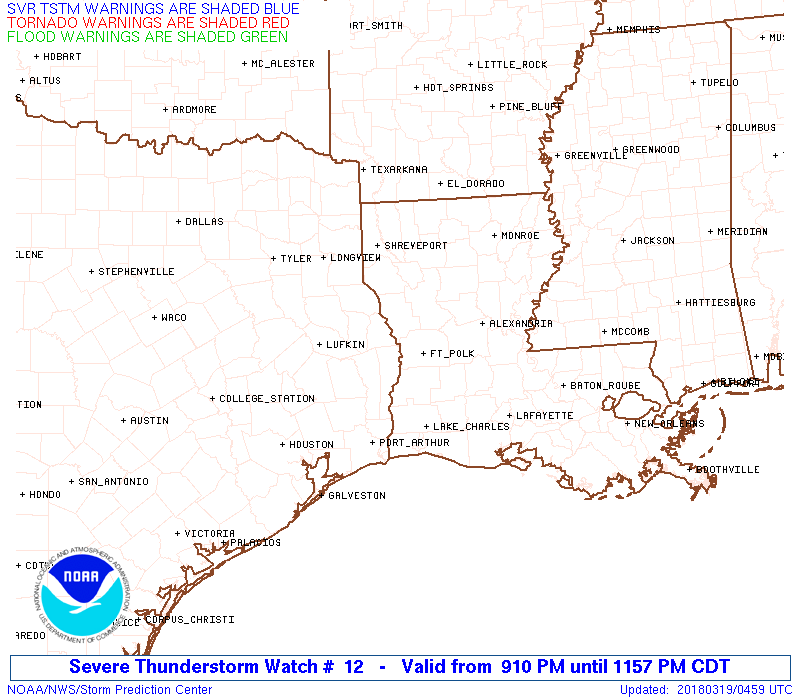
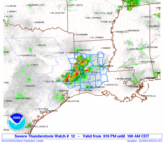
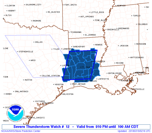
Severe Thunderstorm Watch Number 12
NWS Storm Prediction Center Norman OK
910 PM CDT Sun Mar 18 2018
The NWS Storm Prediction Center has issued a
* Severe Thunderstorm Watch for portions of
Central and southwest Louisiana
Extreme southeast Texas
* Effective this Sunday night and Monday morning from 910 PM
until 100 AM CDT.
* Primary threats include...
Scattered large hail and isolated very large hail events to 2
inches in diameter possible
Isolated damaging wind gusts to 70 mph possible
A tornado or two possible
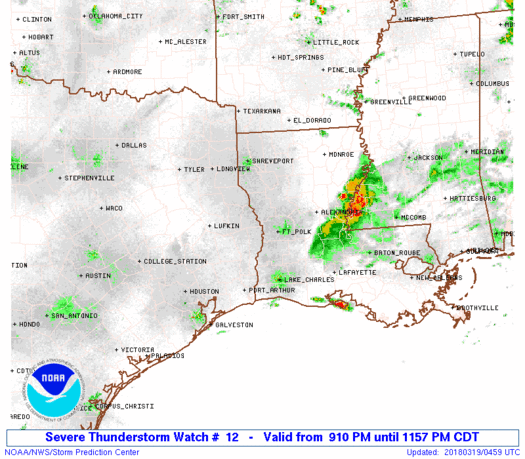
SUMMARY...Clusters of thunderstorms, some with embedded supercell
characteristics, will continue to spread eastward from southeast
Texas into Louisiana overnight. The strongest storms will be
capable of producing large hail and damaging winds, and an isolated
tornado cannot be ruled out.
The severe thunderstorm watch area is approximately along and 65
statute miles east and west of a line from 30 miles north northeast
of Natchitoches LA to 60 miles south southwest of Fort Polk LA. For
a complete depiction of the watch see the associated watch outline
update (WOUS64 KWNS WOU2).
PRECAUTIONARY/PREPAREDNESS ACTIONS...
REMEMBER...A Severe Thunderstorm Watch means conditions are
favorable for severe thunderstorms in and close to the watch area.
Persons in these areas should be on the lookout for threatening
weather conditions and listen for later statements and possible
warnings. Severe thunderstorms can and occasionally do produce
tornadoes.
&&
OTHER WATCH INFORMATION...CONTINUE...WW 11...
AVIATION...A few severe thunderstorms with hail surface and aloft to
2 inches. Extreme turbulence and surface wind gusts to 60 knots. A
few cumulonimbi with maximum tops to 500. Mean storm motion vector
27035.
...Thompson
   SEL2

   URGENT - IMMEDIATE BROADCAST REQUESTED
   Severe Thunderstorm Watch Number 12
   NWS Storm Prediction Center Norman OK
   910 PM CDT Sun Mar 18 2018

   The NWS Storm Prediction Center has issued a

   * Severe Thunderstorm Watch for portions of
     Central and southwest Louisiana
     Extreme southeast Texas

   * Effective this Sunday night and Monday morning from 910 PM
     until 100 AM CDT.

   * Primary threats include...
     Scattered large hail and isolated very large hail events to 2
       inches in diameter possible
     Isolated damaging wind gusts to 70 mph possible
     A tornado or two possible

   SUMMARY...Clusters of thunderstorms, some with embedded supercell
   characteristics, will continue to spread eastward from southeast
   Texas into Louisiana overnight.  The strongest storms will be
   capable of producing large hail and damaging winds, and an isolated
   tornado cannot be ruled out.

   The severe thunderstorm watch area is approximately along and 65
   statute miles east and west of a line from 30 miles north northeast
   of Natchitoches LA to 60 miles south southwest of Fort Polk LA. For
   a complete depiction of the watch see the associated watch outline
   update (WOUS64 KWNS WOU2).

   PRECAUTIONARY/PREPAREDNESS ACTIONS...

   REMEMBER...A Severe Thunderstorm Watch means conditions are
   favorable for severe thunderstorms in and close to the watch area.
   Persons in these areas should be on the lookout for threatening
   weather conditions and listen for later statements and possible
   warnings. Severe thunderstorms can and occasionally do produce
   tornadoes.

   &&

   OTHER WATCH INFORMATION...CONTINUE...WW 11...

   AVIATION...A few severe thunderstorms with hail surface and aloft to
   2 inches. Extreme turbulence and surface wind gusts to 60 knots. A
   few cumulonimbi with maximum tops to 500. Mean storm motion vector
   27035.

   ...Thompson
 Note:
The Aviation Watch (SAW) product is an approximation to the watch area.
The actual watch is depicted by the shaded areas.
Note:
The Aviation Watch (SAW) product is an approximation to the watch area.
The actual watch is depicted by the shaded areas.
   SAW2
   WW 12 SEVERE TSTM LA TX 190210Z - 190600Z
   AXIS..65 STATUTE MILES EAST AND WEST OF LINE..
   30NNE IER/NATCHITOCHES LA/ - 60SSW POE/FORT POLK LA/
   ..AVIATION COORDS.. 55NM E/W /50WSW MLU - 24WNW LCH/
   HAIL SURFACE AND ALOFT..2 INCHES. WIND GUSTS..60 KNOTS.
   MAX TOPS TO 500. MEAN STORM MOTION VECTOR 27035.

   LAT...LON 32139179 30239248 30239465 32139401

   THIS IS AN APPROXIMATION TO THE WATCH AREA.  FOR A
   COMPLETE DEPICTION OF THE WATCH SEE WOUS64 KWNS
   FOR WOU2.
Watch 12 Status Report Messages:
STATUS REPORT #2 ON WW 12

VALID 190445Z - 190540Z

SEVERE WEATHER THREAT CONTINUES RIGHT OF A LINE FROM 30 NW LFT TO
25 SSW ESF TO 15 ESE ESF.

..DIAL..03/19/18

ATTN...WFO...LCH...SHV...

&&

STATUS REPORT FOR WS 12

SEVERE WEATHER THREAT CONTINUES FOR THE FOLLOWING AREAS

LAC009-039-079-097-190540-

LA
.    LOUISIANA PARISHES INCLUDED ARE

AVOYELLES	     EVANGELINE 	 RAPIDES
ST. LANDRY
$$


THE WATCH STATUS MESSAGE IS FOR GUIDANCE PURPOSES ONLY.  PLEASE
REFER TO WATCH COUNTY NOTIFICATION STATEMENTS FOR OFFICIAL
INFORMATION ON COUNTIES...INDEPENDENT CITIES AND MARINE ZONES
CLEARED FROM SEVERE THUNDERSTORM AND TORNADO WATCHES.
$$

STATUS REPORT #1 ON WW 12

VALID 190335Z - 190440Z

SEVERE WEATHER THREAT CONTINUES RIGHT OF A LINE FROM 20 NNE BPT
TO 30 W POE TO 20 ENE IER TO 25 S MLU.

..DIAL..03/19/18

ATTN...WFO...LCH...SHV...

&&

STATUS REPORT FOR WS 12

SEVERE WEATHER THREAT CONTINUES FOR THE FOLLOWING AREAS

LAC001-003-009-011-019-021-039-043-053-059-069-079-097-115-127-
190440-

LA
.    LOUISIANA PARISHES INCLUDED ARE

ACADIA		     ALLEN		 AVOYELLES
BEAUREGARD	     CALCASIEU		 CALDWELL
EVANGELINE	     GRANT		 JEFFERSON DAVIS
LA SALLE	     NATCHITOCHES	 RAPIDES
ST. LANDRY	     VERNON		 WINN
$$


TXC351-190440-

TX
.    TEXAS COUNTIES INCLUDED ARE

NEWTON
$$


THE WATCH STATUS MESSAGE IS FOR GUIDANCE PURPOSES ONLY.  PLEASE
REFER TO WATCH COUNTY NOTIFICATION STATEMENTS FOR OFFICIAL
INFORMATION ON COUNTIES...INDEPENDENT CITIES AND MARINE ZONES
CLEARED FROM SEVERE THUNDERSTORM AND TORNADO WATCHES.
$$
Note:
Click for Complete Product Text.
Tornadoes
Probability of 2 or more tornadoes
|
Low (20%)
|
Probability of 1 or more strong (F2-F5) tornadoes
|
Low (<2%)
|
Wind
Probability of 10 or more severe wind events
|
Mod (30%)
|
Probability of 1 or more wind events > 65 knots
|
Low (10%)
|
Hail
Probability of 10 or more severe hail events
|
Mod (40%)
|
Probability of 1 or more hailstones > 2 inches
|
Mod (30%)
|
Combined Severe Hail/Wind
Probability of 6 or more combined severe hail/wind events
|
High (70%)
|
For each watch, probabilities for particular events inside the watch
(listed above in each table) are determined by the issuing forecaster.
The "Low" category contains probability values ranging from less than 2%
to 20% (F2-F5 tornadoes), less than 5% to 20% (all other probabilities),
"Moderate" from 30% to 60%, and "High" from 70% to greater than 95%.
High values are bolded and lighter in color to provide awareness of
an increased threat for a particular event.


 @NWSSPC