 Note:
The expiration time in the watch graphic is amended if the watch is
replaced, cancelled or extended.
Note:
Note:
The expiration time in the watch graphic is amended if the watch is
replaced, cancelled or extended.
Note: Click for
Watch Status Reports.
SEL4
URGENT - IMMEDIATE BROADCAST REQUESTED
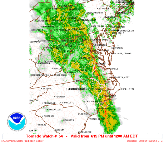
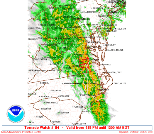
Tornado Watch Number 54
NWS Storm Prediction Center Norman OK
615 PM EDT Sun Apr 15 2018
The NWS Storm Prediction Center has issued a
* Tornado Watch for portions of
South Central Virginia
* Effective this Sunday night from 615 PM until Midnight EDT.
* Primary threats include...
A few tornadoes possible
Scattered damaging wind gusts to 70 mph likely
SUMMARY...A line of intense thunderstorms over central North
Carolina will track north-northeastward into the watch area this
evening, posing a threat of locally damaging wind gusts and a few
tornadoes.
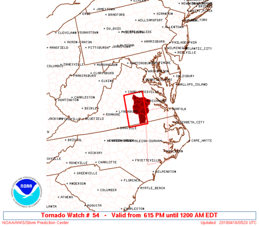
The tornado watch area is approximately along and 30 statute miles
east and west of a line from 90 miles north of South Hill VA to 15
miles south southwest of South Hill VA. For a complete depiction of
the watch see the associated watch outline update (WOUS64 KWNS
WOU4).
PRECAUTIONARY/PREPAREDNESS ACTIONS...
REMEMBER...A Tornado Watch means conditions are favorable for
tornadoes and severe thunderstorms in and close to the watch
area. Persons in these areas should be on the lookout for
threatening weather conditions and listen for later statements
and possible warnings.
&&
OTHER WATCH INFORMATION...CONTINUE...WW 52...WW 53...
AVIATION...Tornadoes and a few severe thunderstorms with hail
surface and aloft to 1 inch. Extreme turbulence and surface wind
gusts to 60 knots. A few cumulonimbi with maximum tops to 450. Mean
storm motion vector 21040.
...Hart
   SEL4

   URGENT - IMMEDIATE BROADCAST REQUESTED
   Tornado Watch Number 54
   NWS Storm Prediction Center Norman OK
   615 PM EDT Sun Apr 15 2018

   The NWS Storm Prediction Center has issued a

   * Tornado Watch for portions of
     South Central Virginia

   * Effective this Sunday night from 615 PM until Midnight EDT.

   * Primary threats include...
     A few tornadoes possible
     Scattered damaging wind gusts to 70 mph likely

   SUMMARY...A line of intense thunderstorms over central North
   Carolina will track north-northeastward into the watch area this
   evening, posing a threat of locally damaging wind gusts and a few
   tornadoes.

   The tornado watch area is approximately along and 30 statute miles
   east and west of a line from 90 miles north of South Hill VA to 15
   miles south southwest of South Hill VA. For a complete depiction of
   the watch see the associated watch outline update (WOUS64 KWNS
   WOU4).

   PRECAUTIONARY/PREPAREDNESS ACTIONS...

   REMEMBER...A Tornado Watch means conditions are favorable for
   tornadoes and severe thunderstorms in and close to the watch
   area. Persons in these areas should be on the lookout for
   threatening weather conditions and listen for later statements
   and possible warnings.

   &&

   OTHER WATCH INFORMATION...CONTINUE...WW 52...WW 53...

   AVIATION...Tornadoes and a few severe thunderstorms with hail
   surface and aloft to 1 inch. Extreme turbulence and surface wind
   gusts to 60 knots. A few cumulonimbi with maximum tops to 450. Mean
   storm motion vector 21040.

   ...Hart
 Note:
The Aviation Watch (SAW) product is an approximation to the watch area.
The actual watch is depicted by the shaded areas.
Note:
The Aviation Watch (SAW) product is an approximation to the watch area.
The actual watch is depicted by the shaded areas.
   SAW4
   WW 54 TORNADO VA 152215Z - 160400Z
   AXIS..30 STATUTE MILES EAST AND WEST OF LINE..
   90N AVC/SOUTH HILL VA/ - 15SSW AVC/SOUTH HILL VA/
   ..AVIATION COORDS.. 25NM E/W /40SSW CSN - 48NE RDU/
   HAIL SURFACE AND ALOFT..1 INCH. WIND GUSTS..60 KNOTS.
   MAX TOPS TO 450. MEAN STORM MOTION VECTOR 21040.

   LAT...LON 37997750 36497761 36497869 37997859

   THIS IS AN APPROXIMATION TO THE WATCH AREA.  FOR A
   COMPLETE DEPICTION OF THE WATCH SEE WOUS64 KWNS
   FOR WOU4.
Watch 54 Status Report Messages:
STATUS REPORT #5 ON WW 54
VALID 160335Z - 160440Z
SEVERE WEATHER THREAT CONTINUES RIGHT OF A LINE FROM 25 WSW AVC
TO 45 SSE CHO TO 20 ESE CHO.
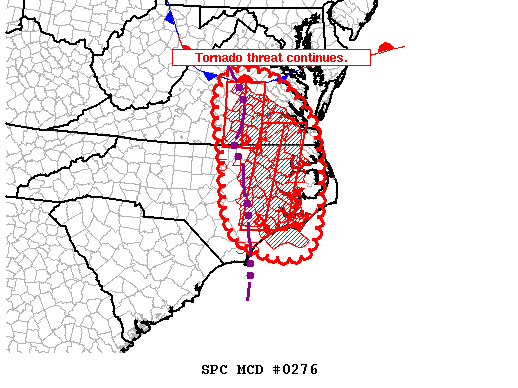
FOR ADDITIONAL INFORMATION SEE MESOSCALE DISCUSSION 276
..COOK..04/16/18
ATTN...WFO...AKQ...
&&
STATUS REPORT FOR WT 54
SEVERE WEATHER THREAT CONTINUES FOR THE FOLLOWING AREAS
VAC007-025-041-053-075-087-111-117-135-145-760-160440-
VA
. VIRGINIA COUNTIES INCLUDED ARE
AMELIA BRUNSWICK CHESTERFIELD
DINWIDDIE GOOCHLAND HENRICO
LUNENBURG MECKLENBURG NOTTOWAY
POWHATAN
VIRGINIA INDEPENDENT CITIES INCLUDED ARE
RICHMOND
$$
THE WATCH STATUS MESSAGE IS FOR GUIDANCE PURPOSES ONLY. PLEASE
REFER TO WATCH COUNTY NOTIFICATION STATEMENTS FOR OFFICIAL
INFORMATION ON COUNTIES...INDEPENDENT CITIES AND MARINE ZONES
CLEARED FROM SEVERE THUNDERSTORM AND TORNADO WATCHES.
$$
STATUS REPORT #4 ON WW 54
VALID 160230Z - 160340Z
SEVERE WEATHER THREAT CONTINUES RIGHT OF A LINE FROM 30 ENE LYH
TO 30 E CHO.
..COOK..04/16/18
ATTN...WFO...AKQ...
&&
STATUS REPORT FOR WT 54
SEVERE WEATHER THREAT CONTINUES FOR THE FOLLOWING AREAS
VAC007-025-041-049-053-075-087-111-117-135-145-147-760-160340-
VA
. VIRGINIA COUNTIES INCLUDED ARE
AMELIA BRUNSWICK CHESTERFIELD
CUMBERLAND DINWIDDIE GOOCHLAND
HENRICO LUNENBURG MECKLENBURG
NOTTOWAY POWHATAN PRINCE EDWARD
VIRGINIA INDEPENDENT CITIES INCLUDED ARE
RICHMOND
$$
THE WATCH STATUS MESSAGE IS FOR GUIDANCE PURPOSES ONLY. PLEASE
REFER TO WATCH COUNTY NOTIFICATION STATEMENTS FOR OFFICIAL
INFORMATION ON COUNTIES...INDEPENDENT CITIES AND MARINE ZONES
CLEARED FROM SEVERE THUNDERSTORM AND TORNADO WATCHES.
$$
STATUS REPORT #3 ON WW 54
VALID 160125Z - 160240Z
THE SEVERE WEATHER THREAT CONTINUES ACROSS THE ENTIRE WATCH AREA.
..COOK..04/16/18
ATTN...WFO...AKQ...
&&
STATUS REPORT FOR WT 54
SEVERE WEATHER THREAT CONTINUES FOR THE FOLLOWING AREAS
VAC007-025-041-049-053-065-075-087-111-117-135-145-147-760-
160240-
VA
. VIRGINIA COUNTIES INCLUDED ARE
AMELIA BRUNSWICK CHESTERFIELD
CUMBERLAND DINWIDDIE FLUVANNA
GOOCHLAND HENRICO LUNENBURG
MECKLENBURG NOTTOWAY POWHATAN
PRINCE EDWARD
VIRGINIA INDEPENDENT CITIES INCLUDED ARE
RICHMOND
$$
THE WATCH STATUS MESSAGE IS FOR GUIDANCE PURPOSES ONLY. PLEASE
REFER TO WATCH COUNTY NOTIFICATION STATEMENTS FOR OFFICIAL
INFORMATION ON COUNTIES...INDEPENDENT CITIES AND MARINE ZONES
CLEARED FROM SEVERE THUNDERSTORM AND TORNADO WATCHES.
$$
STATUS REPORT #2 ON WW 54
VALID 160035Z - 160140Z
THE SEVERE WEATHER THREAT CONTINUES ACROSS THE ENTIRE WATCH AREA.
FOR ADDITIONAL INFORMATION SEE MESOSCALE DISCUSSION 274
..COOK..04/16/18
ATTN...WFO...AKQ...
&&
STATUS REPORT FOR WT 54
SEVERE WEATHER THREAT CONTINUES FOR THE FOLLOWING AREAS
VAC007-025-041-049-053-065-075-087-111-117-135-145-147-760-
160140-
VA
. VIRGINIA COUNTIES INCLUDED ARE
AMELIA BRUNSWICK CHESTERFIELD
CUMBERLAND DINWIDDIE FLUVANNA
GOOCHLAND HENRICO LUNENBURG
MECKLENBURG NOTTOWAY POWHATAN
PRINCE EDWARD
VIRGINIA INDEPENDENT CITIES INCLUDED ARE
RICHMOND
$$
THE WATCH STATUS MESSAGE IS FOR GUIDANCE PURPOSES ONLY. PLEASE
REFER TO WATCH COUNTY NOTIFICATION STATEMENTS FOR OFFICIAL
INFORMATION ON COUNTIES...INDEPENDENT CITIES AND MARINE ZONES
CLEARED FROM SEVERE THUNDERSTORM AND TORNADO WATCHES.
$$
STATUS REPORT #1 ON WW 54
VALID 152330Z - 160040Z
THE SEVERE WEATHER THREAT CONTINUES ACROSS THE ENTIRE WATCH AREA.
..COOK..04/15/18
ATTN...WFO...AKQ...
&&
STATUS REPORT FOR WT 54
SEVERE WEATHER THREAT CONTINUES FOR THE FOLLOWING AREAS
VAC007-025-041-049-053-065-075-087-111-117-135-145-147-760-
160040-
VA
. VIRGINIA COUNTIES INCLUDED ARE
AMELIA BRUNSWICK CHESTERFIELD
CUMBERLAND DINWIDDIE FLUVANNA
GOOCHLAND HENRICO LUNENBURG
MECKLENBURG NOTTOWAY POWHATAN
PRINCE EDWARD
VIRGINIA INDEPENDENT CITIES INCLUDED ARE
RICHMOND
$$
THE WATCH STATUS MESSAGE IS FOR GUIDANCE PURPOSES ONLY. PLEASE
REFER TO WATCH COUNTY NOTIFICATION STATEMENTS FOR OFFICIAL
INFORMATION ON COUNTIES...INDEPENDENT CITIES AND MARINE ZONES
CLEARED FROM SEVERE THUNDERSTORM AND TORNADO WATCHES.
$$
Note:
Click for Complete Product Text.
Tornadoes
Probability of 2 or more tornadoes
|
Mod (50%)
|
Probability of 1 or more strong (F2-F5) tornadoes
|
Low (10%)
|
Wind
Probability of 10 or more severe wind events
|
Mod (60%)
|
Probability of 1 or more wind events > 65 knots
|
Low (20%)
|
Hail
Probability of 10 or more severe hail events
|
Low (10%)
|
Probability of 1 or more hailstones > 2 inches
|
Low (<5%)
|
Combined Severe Hail/Wind
Probability of 6 or more combined severe hail/wind events
|
High (70%)
|
For each watch, probabilities for particular events inside the watch
(listed above in each table) are determined by the issuing forecaster.
The "Low" category contains probability values ranging from less than 2%
to 20% (F2-F5 tornadoes), less than 5% to 20% (all other probabilities),
"Moderate" from 30% to 60%, and "High" from 70% to greater than 95%.
High values are bolded and lighter in color to provide awareness of
an increased threat for a particular event.


 @NWSSPC