 Note:
The expiration time in the watch graphic is amended if the watch is
replaced, cancelled or extended.
Note:
Note:
The expiration time in the watch graphic is amended if the watch is
replaced, cancelled or extended.
Note: Click for
Watch Status Reports.
SEL1
URGENT - IMMEDIATE BROADCAST REQUESTED
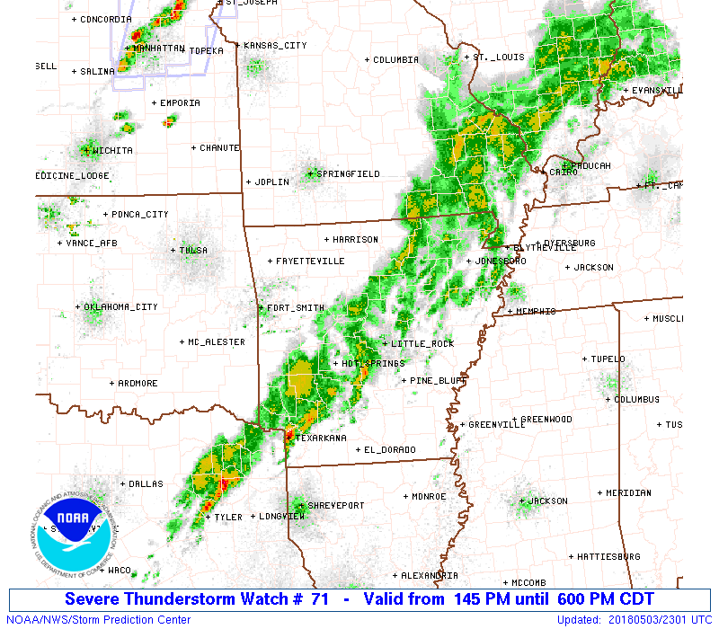
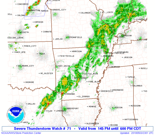
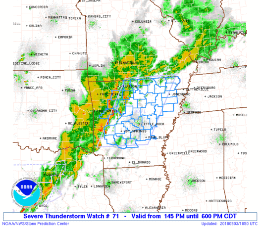
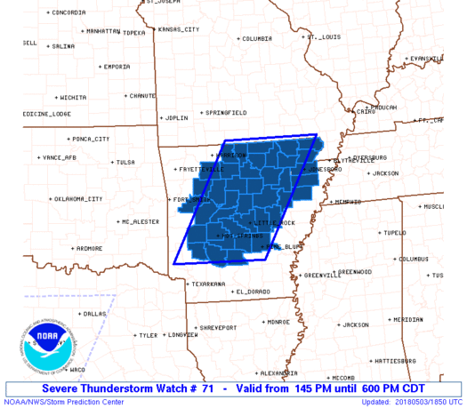
Severe Thunderstorm Watch Number 71
NWS Storm Prediction Center Norman OK
145 PM CDT Thu May 3 2018
The NWS Storm Prediction Center has issued a
* Severe Thunderstorm Watch for portions of
Central and Northeast Arkansas
* Effective this Thursday afternoon and evening from 145 PM until
600 PM CDT.
* Primary threats include...
Scattered damaging wind gusts to 70 mph possible
Isolated large hail events to 1.5 inches in diameter possible
A tornado or two possible
SUMMARY...A line of thunderstorms over western Arkansas will track
northeastward across the watch area this afternoon, posing a risk of
locally damaging wind gusts.
The severe thunderstorm watch area is approximately along and 70
statute miles east and west of a line from 45 miles northwest of
Walnut Ridge AR to 40 miles south of Hot Springs AR. For a complete
depiction of the watch see the associated watch outline update
(WOUS64 KWNS WOU1).
PRECAUTIONARY/PREPAREDNESS ACTIONS...
REMEMBER...A Severe Thunderstorm Watch means conditions are
favorable for severe thunderstorms in and close to the watch area.
Persons in these areas should be on the lookout for threatening
weather conditions and listen for later statements and possible
warnings. Severe thunderstorms can and occasionally do produce
tornadoes.
&&
OTHER WATCH INFORMATION...CONTINUE...WW 70...
AVIATION...A few severe thunderstorms with hail surface and aloft to
1.5 inches. Extreme turbulence and surface wind gusts to 60 knots. A
few cumulonimbi with maximum tops to 450. Mean storm motion vector
24035.
...Hart
   SEL1

   URGENT - IMMEDIATE BROADCAST REQUESTED
   Severe Thunderstorm Watch Number 71
   NWS Storm Prediction Center Norman OK
   145 PM CDT Thu May 3 2018

   The NWS Storm Prediction Center has issued a

   * Severe Thunderstorm Watch for portions of
     Central and Northeast Arkansas

   * Effective this Thursday afternoon and evening from 145 PM until
     600 PM CDT.

   * Primary threats include...
     Scattered damaging wind gusts to 70 mph possible
     Isolated large hail events to 1.5 inches in diameter possible
     A tornado or two possible

   SUMMARY...A line of thunderstorms over western Arkansas will track
   northeastward across the watch area this afternoon, posing a risk of
   locally damaging wind gusts.

   The severe thunderstorm watch area is approximately along and 70
   statute miles east and west of a line from 45 miles northwest of
   Walnut Ridge AR to 40 miles south of Hot Springs AR. For a complete
   depiction of the watch see the associated watch outline update
   (WOUS64 KWNS WOU1).

   PRECAUTIONARY/PREPAREDNESS ACTIONS...

   REMEMBER...A Severe Thunderstorm Watch means conditions are
   favorable for severe thunderstorms in and close to the watch area.
   Persons in these areas should be on the lookout for threatening
   weather conditions and listen for later statements and possible
   warnings. Severe thunderstorms can and occasionally do produce
   tornadoes.

   &&

   OTHER WATCH INFORMATION...CONTINUE...WW 70...

   AVIATION...A few severe thunderstorms with hail surface and aloft to
   1.5 inches. Extreme turbulence and surface wind gusts to 60 knots. A
   few cumulonimbi with maximum tops to 450. Mean storm motion vector
   24035.

   ...Hart
 Note:
The Aviation Watch (SAW) product is an approximation to the watch area.
The actual watch is depicted by the shaded areas.
Note:
The Aviation Watch (SAW) product is an approximation to the watch area.
The actual watch is depicted by the shaded areas.
   SAW1
   WW 71 SEVERE TSTM AR 031845Z - 032300Z
   AXIS..70 STATUTE MILES EAST AND WEST OF LINE..
   45NW ARG/WALNUT RIDGE AR/ - 40S HOT/HOT SPRINGS AR/
   ..AVIATION COORDS.. 60NM E/W /39NW ARG - 42NNW ELD/
   HAIL SURFACE AND ALOFT..1.5 INCHES. WIND GUSTS..60 KNOTS.
   MAX TOPS TO 450. MEAN STORM MOTION VECTOR 24035.

   LAT...LON 36589023 33889187 33889431 36589276

   THIS IS AN APPROXIMATION TO THE WATCH AREA.  FOR A
   COMPLETE DEPICTION OF THE WATCH SEE WOUS64 KWNS
   FOR WOU1.
Watch 71 Status Report Messages:
STATUS REPORT #3 ON WW 71

VALID 032130Z - 032240Z

SEVERE WEATHER THREAT CONTINUES RIGHT OF A LINE FROM 25 NNE TXK
TO 40 SSW BVX TO 25 E UNO.

..BENTLEY..05/03/18

ATTN...WFO...LZK...MEG...

&&

STATUS REPORT FOR WS 71

SEVERE WEATHER THREAT CONTINUES FOR THE FOLLOWING AREAS

ARC019-021-031-037-039-053-055-059-063-067-069-075-085-111-117-
119-121-125-135-145-147-032240-

AR
.    ARKANSAS COUNTIES INCLUDED ARE

CLARK		     CLAY		 CRAIGHEAD
CROSS		     DALLAS		 GRANT
GREENE		     HOT SPRING 	 INDEPENDENCE
JACKSON 	     JEFFERSON		 LAWRENCE
LONOKE		     POINSETT		 PRAIRIE
PULASKI 	     RANDOLPH		 SALINE
SHARP		     WHITE		 WOODRUFF
$$


THE WATCH STATUS MESSAGE IS FOR GUIDANCE PURPOSES ONLY.  PLEASE
REFER TO WATCH COUNTY NOTIFICATION STATEMENTS FOR OFFICIAL
INFORMATION ON COUNTIES...INDEPENDENT CITIES AND MARINE ZONES
CLEARED FROM SEVERE THUNDERSTORM AND TORNADO WATCHES.
$$

STATUS REPORT #2 ON WW 71

VALID 032035Z - 032140Z

SEVERE WEATHER THREAT CONTINUES RIGHT OF A LINE FROM 25 SE DEQ TO
30 NNE HOT TO 35 N LIT TO 35 WSW BVX TO 35 S FLP TO 10 SW UNO.

..GLEASON..05/03/18

ATTN...WFO...LZK...MEG...

&&

STATUS REPORT FOR WS 71

SEVERE WEATHER THREAT CONTINUES FOR THE FOLLOWING AREAS

ARC019-021-023-031-037-039-045-049-051-053-055-059-063-065-067-
069-075-085-109-111-117-119-121-125-135-137-145-147-032140-

AR
.    ARKANSAS COUNTIES INCLUDED ARE

CLARK		     CLAY		 CLEBURNE
CRAIGHEAD	     CROSS		 DALLAS
FAULKNER	     FULTON		 GARLAND
GRANT		     GREENE		 HOT SPRING
INDEPENDENCE	     IZARD		 JACKSON
JEFFERSON	     LAWRENCE		 LONOKE
PIKE		     POINSETT		 PRAIRIE
PULASKI 	     RANDOLPH		 SALINE
SHARP		     STONE		 WHITE
WOODRUFF
$$


THE WATCH STATUS MESSAGE IS FOR GUIDANCE PURPOSES ONLY.  PLEASE
REFER TO WATCH COUNTY NOTIFICATION STATEMENTS FOR OFFICIAL
INFORMATION ON COUNTIES...INDEPENDENT CITIES AND MARINE ZONES
CLEARED FROM SEVERE THUNDERSTORM AND TORNADO WATCHES.
$$

STATUS REPORT #1 ON WW 71

VALID 031945Z - 032040Z

SEVERE WEATHER THREAT CONTINUES RIGHT OF A LINE FROM 20 NE DEQ TO
10 S RUE TO 30 NE HRO.

..GLEASON..05/03/18

ATTN...WFO...LZK...MEG...

&&

STATUS REPORT FOR WS 71

SEVERE WEATHER THREAT CONTINUES FOR THE FOLLOWING AREAS

ARC005-019-021-023-029-031-037-039-045-049-051-053-055-059-063-
065-067-069-075-085-089-097-105-109-111-115-117-119-121-125-129-
135-137-141-145-147-032040-

AR
.    ARKANSAS COUNTIES INCLUDED ARE

BAXTER		     CLARK		 CLAY
CLEBURNE	     CONWAY		 CRAIGHEAD
CROSS		     DALLAS		 FAULKNER
FULTON		     GARLAND		 GRANT
GREENE		     HOT SPRING 	 INDEPENDENCE
IZARD		     JACKSON		 JEFFERSON
LAWRENCE	     LONOKE		 MARION
MONTGOMERY	     PERRY		 PIKE
POINSETT	     POPE		 PRAIRIE
PULASKI 	     RANDOLPH		 SALINE
SEARCY		     SHARP		 STONE
VAN BUREN	     WHITE		 WOODRUFF
$$


THE WATCH STATUS MESSAGE IS FOR GUIDANCE PURPOSES ONLY.  PLEASE
REFER TO WATCH COUNTY NOTIFICATION STATEMENTS FOR OFFICIAL
INFORMATION ON COUNTIES...INDEPENDENT CITIES AND MARINE ZONES
CLEARED FROM SEVERE THUNDERSTORM AND TORNADO WATCHES.
$$
Note:
Click for Complete Product Text.
Tornadoes
Probability of 2 or more tornadoes
|
Low (20%)
|
Probability of 1 or more strong (F2-F5) tornadoes
|
Low (<2%)
|
Wind
Probability of 10 or more severe wind events
|
Mod (50%)
|
Probability of 1 or more wind events > 65 knots
|
Low (20%)
|
Hail
Probability of 10 or more severe hail events
|
Mod (30%)
|
Probability of 1 or more hailstones > 2 inches
|
Low (10%)
|
Combined Severe Hail/Wind
Probability of 6 or more combined severe hail/wind events
|
High (70%)
|
For each watch, probabilities for particular events inside the watch
(listed above in each table) are determined by the issuing forecaster.
The "Low" category contains probability values ranging from less than 2%
to 20% (F2-F5 tornadoes), less than 5% to 20% (all other probabilities),
"Moderate" from 30% to 60%, and "High" from 70% to greater than 95%.
High values are bolded and lighter in color to provide awareness of
an increased threat for a particular event.


 @NWSSPC