 Note:
The expiration time in the watch graphic is amended if the watch is
replaced, cancelled or extended.
Note:
Note:
The expiration time in the watch graphic is amended if the watch is
replaced, cancelled or extended.
Note: Click for
Watch Status Reports.
SEL9
URGENT - IMMEDIATE BROADCAST REQUESTED
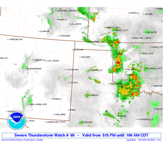
Severe Thunderstorm Watch Number 99
NWS Storm Prediction Center Norman OK
515 PM CDT Tue May 15 2018
The NWS Storm Prediction Center has issued a
* Severe Thunderstorm Watch for portions of
Northeast New Mexico
Oklahoma Panhandle
Texas Panhandle
* Effective this Tuesday afternoon and Wednesday morning from 515
PM until 100 AM CDT.
* Primary threats include...
Scattered large hail and isolated very large hail events to 2
inches in diameter possible
Scattered damaging wind gusts to 70 mph possible
SUMMARY...Isolated supercells will spread east-southeast into the
Texas/Oklahoma Panhandle region. Large hail and damaging winds will
accompany this activity into the late evening hours.
The severe thunderstorm watch area is approximately along and 65
statute miles east and west of a line from 35 miles east southeast
of Lubbock TX to 40 miles north northeast of Clayton NM. For a
complete depiction of the watch see the associated watch outline
update (WOUS64 KWNS WOU9).
PRECAUTIONARY/PREPAREDNESS ACTIONS...
REMEMBER...A Severe Thunderstorm Watch means conditions are
favorable for severe thunderstorms in and close to the watch area.
Persons in these areas should be on the lookout for threatening
weather conditions and listen for later statements and possible
warnings. Severe thunderstorms can and occasionally do produce
tornadoes.
&&
OTHER WATCH INFORMATION...CONTINUE...WW 93...WW 95...WW 96...WW
97...WW 98...
AVIATION...A few severe thunderstorms with hail surface and aloft to
2 inches. Extreme turbulence and surface wind gusts to 60 knots. A
few cumulonimbi with maximum tops to 500. Mean storm motion vector
30020.
...Darrow
 Note:
The Aviation Watch (SAW) product is an approximation to the watch area.
The actual watch is depicted by the shaded areas.
Note:
The Aviation Watch (SAW) product is an approximation to the watch area.
The actual watch is depicted by the shaded areas.
   SAW9
   WW 99 SEVERE TSTM NM OK TX 152215Z - 160600Z
   AXIS..65 STATUTE MILES EAST AND WEST OF LINE..
   35ESE LBB/LUBBOCK TX/ - 40NNE CAO/CLAYTON NM/
   ..AVIATION COORDS.. 55NM E/W /36ESE LBB - 39ESE TBE/
   HAIL SURFACE AND ALOFT..2 INCHES. WIND GUSTS..60 KNOTS.
   MAX TOPS TO 500. MEAN STORM MOTION VECTOR 30020.

   LAT...LON 33470238 36970405 36970169 33470012

   THIS IS AN APPROXIMATION TO THE WATCH AREA.  FOR A
   COMPLETE DEPICTION OF THE WATCH SEE WOUS64 KWNS
   FOR WOU9.
Watch 99 Status Report Messages:
STATUS REPORT #3 ON WW 99

VALID 160350Z - 160440Z

SEVERE WEATHER THREAT CONTINUES RIGHT OF A LINE FROM 65 ESE LBB
TO 40 SE BGD.

..SPC..05/16/18

ATTN...WFO...ABQ...AMA...LUB...

&&

STATUS REPORT FOR WS 99

SEVERE WEATHER THREAT CONTINUES FOR THE FOLLOWING AREAS

TXC101-125-129-179-191-269-345-160440-

TX
.    TEXAS COUNTIES INCLUDED ARE

COTTLE		     DICKENS		 DONLEY
GRAY		     HALL		 KING
MOTLEY
$$


THE WATCH STATUS MESSAGE IS FOR GUIDANCE PURPOSES ONLY.  PLEASE
REFER TO WATCH COUNTY NOTIFICATION STATEMENTS FOR OFFICIAL
INFORMATION ON COUNTIES...INDEPENDENT CITIES AND MARINE ZONES
CLEARED FROM SEVERE THUNDERSTORM AND TORNADO WATCHES.
$$

STATUS REPORT #2 ON WW 99

VALID 160220Z - 160340Z

SEVERE WEATHER THREAT CONTINUES RIGHT OF A LINE FROM 25 SW LBB TO
20 S AMA TO 5 ESE EHA.

..SPC..05/16/18

ATTN...WFO...ABQ...AMA...LUB...

&&

STATUS REPORT FOR WS 99

SEVERE WEATHER THREAT CONTINUES FOR THE FOLLOWING AREAS

OKC139-160340-

OK
.    OKLAHOMA COUNTIES INCLUDED ARE

TEXAS
$$


TXC011-045-065-101-107-125-129-153-179-189-191-195-233-269-303-
345-421-437-160340-

TX
.    TEXAS COUNTIES INCLUDED ARE

ARMSTRONG	     BRISCOE		 CARSON
COTTLE		     CROSBY		 DICKENS
DONLEY		     FLOYD		 GRAY
HALE		     HALL		 HANSFORD
HUTCHINSON	     KING		 LUBBOCK
MOTLEY		     SHERMAN		 SWISHER
$$


THE WATCH STATUS MESSAGE IS FOR GUIDANCE PURPOSES ONLY.  PLEASE
REFER TO WATCH COUNTY NOTIFICATION STATEMENTS FOR OFFICIAL
INFORMATION ON COUNTIES...INDEPENDENT CITIES AND MARINE ZONES
CLEARED FROM SEVERE THUNDERSTORM AND TORNADO WATCHES.
$$

STATUS REPORT #1 ON WW 99

VALID 160030Z - 160140Z

SEVERE WEATHER THREAT CONTINUES RIGHT OF A LINE FROM 30 NE CVS TO
30 SW SPD.

..SPC..05/16/18

ATTN...WFO...ABQ...AMA...LUB...

&&

STATUS REPORT FOR WS 99

SEVERE WEATHER THREAT CONTINUES FOR THE FOLLOWING AREAS

OKC025-139-160140-

OK
.    OKLAHOMA COUNTIES INCLUDED ARE

CIMARRON	     TEXAS
$$


TXC011-017-045-065-069-101-107-111-117-125-129-153-179-189-191-
195-205-219-233-269-279-303-341-345-359-369-375-381-421-437-
160140-

TX
.    TEXAS COUNTIES INCLUDED ARE

ARMSTRONG	     BAILEY		 BRISCOE
CARSON		     CASTRO		 COTTLE
CROSBY		     DALLAM		 DEAF SMITH
DICKENS 	     DONLEY		 FLOYD
GRAY		     HALE		 HALL
HANSFORD	     HARTLEY		 HOCKLEY
HUTCHINSON	     KING		 LAMB
LUBBOCK 	     MOORE		 MOTLEY
OLDHAM		     PARMER		 POTTER
RANDALL 	     SHERMAN		 SWISHER
$$


THE WATCH STATUS MESSAGE IS FOR GUIDANCE PURPOSES ONLY.  PLEASE
REFER TO WATCH COUNTY NOTIFICATION STATEMENTS FOR OFFICIAL
INFORMATION ON COUNTIES...INDEPENDENT CITIES AND MARINE ZONES
CLEARED FROM SEVERE THUNDERSTORM AND TORNADO WATCHES.
$$
Note:
Click for Complete Product Text.
Tornadoes
Probability of 2 or more tornadoes
|
Low (10%)
|
Probability of 1 or more strong (F2-F5) tornadoes
|
Low (<2%)
|
Wind
Probability of 10 or more severe wind events
|
Mod (40%)
|
Probability of 1 or more wind events > 65 knots
|
Low (20%)
|
Hail
Probability of 10 or more severe hail events
|
Mod (40%)
|
Probability of 1 or more hailstones > 2 inches
|
Mod (40%)
|
Combined Severe Hail/Wind
Probability of 6 or more combined severe hail/wind events
|
High (70%)
|
For each watch, probabilities for particular events inside the watch
(listed above in each table) are determined by the issuing forecaster.
The "Low" category contains probability values ranging from less than 2%
to 20% (F2-F5 tornadoes), less than 5% to 20% (all other probabilities),
"Moderate" from 30% to 60%, and "High" from 70% to greater than 95%.
High values are bolded and lighter in color to provide awareness of
an increased threat for a particular event.


 @NWSSPC


