 Note:
The expiration time in the watch graphic is amended if the watch is
replaced, cancelled or extended.
Note:
Note:
The expiration time in the watch graphic is amended if the watch is
replaced, cancelled or extended.
Note: Click for
Watch Status Reports.
SEL8
URGENT - IMMEDIATE BROADCAST REQUESTED
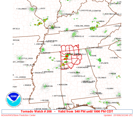
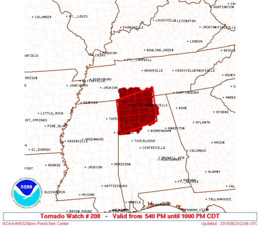
Tornado Watch Number 208
NWS Storm Prediction Center Norman OK
540 PM CDT Sat Jun 23 2018
The NWS Storm Prediction Center has issued a
* Tornado Watch for portions of
Northern Alabama
Southern Middle Tennessee
* Effective this Saturday afternoon and evening from 540 PM until
1000 PM CDT.
* Primary threats include...
A couple tornadoes possible
Isolated damaging wind gusts to 60 mph possible
Isolated large hail events to 1.5 inches in diameter possible
SUMMARY...A couple supercells have developed across northwest
Alabama and may persist for a few hours along a remnant outflow
boundary. Although coverage should be limited, all severe hazards
are possible.
The tornado watch area is approximately along and 50 statute miles
north and south of a line from 45 miles southwest of Muscle Shoals
AL to 30 miles east of Huntsville AL. For a complete depiction of
the watch see the associated watch outline update (WOUS64 KWNS
WOU8).
PRECAUTIONARY/PREPAREDNESS ACTIONS...
REMEMBER...A Tornado Watch means conditions are favorable for
tornadoes and severe thunderstorms in and close to the watch
area. Persons in these areas should be on the lookout for
threatening weather conditions and listen for later statements
and possible warnings.
&&
OTHER WATCH INFORMATION...CONTINUE...WW 205...WW 206...WW 207...
AVIATION...Tornadoes and a few severe thunderstorms with hail
surface and aloft to 1.5 inches. Extreme turbulence and surface wind
gusts to 50 knots. A few cumulonimbi with maximum tops to 500. Mean
storm motion vector 27025.
...Grams
   SEL8

   URGENT - IMMEDIATE BROADCAST REQUESTED
   Tornado Watch Number 208
   NWS Storm Prediction Center Norman OK
   540 PM CDT Sat Jun 23 2018

   The NWS Storm Prediction Center has issued a

   * Tornado Watch for portions of
     Northern Alabama
     Southern Middle Tennessee

   * Effective this Saturday afternoon and evening from 540 PM until
     1000 PM CDT.

   * Primary threats include...
     A couple tornadoes possible
     Isolated damaging wind gusts to 60 mph possible
     Isolated large hail events to 1.5 inches in diameter possible

   SUMMARY...A couple supercells have developed across northwest
   Alabama and may persist for a few hours along a remnant outflow
   boundary. Although coverage should be limited, all severe hazards
   are possible.

   The tornado watch area is approximately along and 50 statute miles
   north and south of a line from 45 miles southwest of Muscle Shoals
   AL to 30 miles east of Huntsville AL. For a complete depiction of
   the watch see the associated watch outline update (WOUS64 KWNS
   WOU8).

   PRECAUTIONARY/PREPAREDNESS ACTIONS...

   REMEMBER...A Tornado Watch means conditions are favorable for
   tornadoes and severe thunderstorms in and close to the watch
   area. Persons in these areas should be on the lookout for
   threatening weather conditions and listen for later statements
   and possible warnings.

   &&

   OTHER WATCH INFORMATION...CONTINUE...WW 205...WW 206...WW 207...

   AVIATION...Tornadoes and a few severe thunderstorms with hail
   surface and aloft to 1.5 inches. Extreme turbulence and surface wind
   gusts to 50 knots. A few cumulonimbi with maximum tops to 500. Mean
   storm motion vector 27025.

   ...Grams
 Note:
The Aviation Watch (SAW) product is an approximation to the watch area.
The actual watch is depicted by the shaded areas.
Note:
The Aviation Watch (SAW) product is an approximation to the watch area.
The actual watch is depicted by the shaded areas.
   SAW8
   WW 208 TORNADO AL TN 232240Z - 240300Z
   AXIS..50 STATUTE MILES NORTH AND SOUTH OF LINE..
   45SW MSL/MUSCLE SHOALS AL/ - 30E HSV/HUNTSVILLE AL/
   ..AVIATION COORDS.. 45NM N/S /42SW MSL - 57WSW GQO/
   HAIL SURFACE AND ALOFT..1.5 INCHES. WIND GUSTS..50 KNOTS.
   MAX TOPS TO 500. MEAN STORM MOTION VECTOR 27025.

   LAT...LON 35008818 35368625 33938625 33568818

   THIS IS AN APPROXIMATION TO THE WATCH AREA.  FOR A
   COMPLETE DEPICTION OF THE WATCH SEE WOUS64 KWNS
   FOR WOU8.
Watch 208 Status Report Messages:
STATUS REPORT #4 ON WW 208

VALID 240235Z - 240300Z

SEVERE WEATHER THREAT CONTINUES RIGHT OF A LINE FROM 30 N GAD TO
40 WNW MSL.

WW 208 WILL BE ALLOWED TO EXPIRE AT 240300Z.

..WENDT..06/24/18

ATTN...WFO...BMX...HUN...OHX...

&&

STATUS REPORT FOR WT 208

SEVERE WEATHER THREAT CONTINUES FOR THE FOLLOWING AREAS

ALC077-083-089-240300-

AL
.    ALABAMA COUNTIES INCLUDED ARE

LAUDERDALE	     LIMESTONE		 MADISON
$$


TNC055-099-103-127-181-240300-

TN
.    TENNESSEE COUNTIES INCLUDED ARE

GILES		     LAWRENCE		 LINCOLN
MOORE		     WAYNE
$$


THE WATCH STATUS MESSAGE IS FOR GUIDANCE PURPOSES ONLY.  PLEASE
REFER TO WATCH COUNTY NOTIFICATION STATEMENTS FOR OFFICIAL
INFORMATION ON COUNTIES...INDEPENDENT CITIES AND MARINE ZONES
CLEARED FROM SEVERE THUNDERSTORM AND TORNADO WATCHES.
$$

STATUS REPORT #3 ON WW 208

VALID 240130Z - 240240Z

SEVERE WEATHER THREAT CONTINUES RIGHT OF A LINE FROM 25 ESE TUP
TO 40 NE CBM TO 35 S MSL TO 5 SSE MSL TO 35 WNW MSL.

FOR ADDITIONAL INFORMATION SEE MESOSCALE DISCUSSION 847

..WENDT..06/24/18

ATTN...WFO...BMX...HUN...OHX...

&&

STATUS REPORT FOR WT 208

SEVERE WEATHER THREAT CONTINUES FOR THE FOLLOWING AREAS

ALC009-043-057-075-077-079-083-089-095-103-127-133-240240-

AL
.    ALABAMA COUNTIES INCLUDED ARE

BLOUNT		     CULLMAN		 FAYETTE
LAMAR		     LAUDERDALE 	 LAWRENCE
LIMESTONE	     MADISON		 MARSHALL
MORGAN		     WALKER		 WINSTON
$$


TNC055-099-103-127-181-240240-

TN
.    TENNESSEE COUNTIES INCLUDED ARE

GILES		     LAWRENCE		 LINCOLN
MOORE		     WAYNE
$$


THE WATCH STATUS MESSAGE IS FOR GUIDANCE PURPOSES ONLY.  PLEASE
REFER TO WATCH COUNTY NOTIFICATION STATEMENTS FOR OFFICIAL
INFORMATION ON COUNTIES...INDEPENDENT CITIES AND MARINE ZONES
CLEARED FROM SEVERE THUNDERSTORM AND TORNADO WATCHES.
$$

STATUS REPORT #2 ON WW 208

VALID 240040Z - 240140Z

SEVERE WEATHER THREAT CONTINUES RIGHT OF A LINE FROM 25 ESE TUP
TO 40 NE CBM TO 35 S MSL TO 20 S MSL TO 5 SSE MSL TO 30 WNW MSL.

..WENDT..06/24/18

ATTN...WFO...BMX...HUN...OHX...

&&

STATUS REPORT FOR WT 208

SEVERE WEATHER THREAT CONTINUES FOR THE FOLLOWING AREAS

ALC009-043-057-075-077-079-083-089-095-103-127-133-240140-

AL
.    ALABAMA COUNTIES INCLUDED ARE

BLOUNT		     CULLMAN		 FAYETTE
LAMAR		     LAUDERDALE 	 LAWRENCE
LIMESTONE	     MADISON		 MARSHALL
MORGAN		     WALKER		 WINSTON
$$


TNC055-099-103-127-181-240140-

TN
.    TENNESSEE COUNTIES INCLUDED ARE

GILES		     LAWRENCE		 LINCOLN
MOORE		     WAYNE
$$


THE WATCH STATUS MESSAGE IS FOR GUIDANCE PURPOSES ONLY.  PLEASE
REFER TO WATCH COUNTY NOTIFICATION STATEMENTS FOR OFFICIAL
INFORMATION ON COUNTIES...INDEPENDENT CITIES AND MARINE ZONES
CLEARED FROM SEVERE THUNDERSTORM AND TORNADO WATCHES.
$$

STATUS REPORT #1 ON WW 208

VALID 232345Z - 240040Z

THE SEVERE WEATHER THREAT CONTINUES ACROSS THE ENTIRE WATCH AREA.

..WENDT..06/23/18

ATTN...WFO...BMX...HUN...OHX...

&&

STATUS REPORT FOR WT 208

SEVERE WEATHER THREAT CONTINUES FOR THE FOLLOWING AREAS

ALC009-033-043-057-059-075-077-079-083-089-093-095-103-127-133-
240040-

AL
.    ALABAMA COUNTIES INCLUDED ARE

BLOUNT		     COLBERT		 CULLMAN
FAYETTE 	     FRANKLIN		 LAMAR
LAUDERDALE	     LAWRENCE		 LIMESTONE
MADISON 	     MARION		 MARSHALL
MORGAN		     WALKER		 WINSTON
$$


TNC055-099-103-127-181-240040-

TN
.    TENNESSEE COUNTIES INCLUDED ARE

GILES		     LAWRENCE		 LINCOLN
MOORE		     WAYNE
$$


THE WATCH STATUS MESSAGE IS FOR GUIDANCE PURPOSES ONLY.  PLEASE
REFER TO WATCH COUNTY NOTIFICATION STATEMENTS FOR OFFICIAL
INFORMATION ON COUNTIES...INDEPENDENT CITIES AND MARINE ZONES
CLEARED FROM SEVERE THUNDERSTORM AND TORNADO WATCHES.
$$
Note:
Click for Complete Product Text.
Tornadoes
Probability of 2 or more tornadoes
|
Mod (30%)
|
Probability of 1 or more strong (F2-F5) tornadoes
|
Low (20%)
|
Wind
Probability of 10 or more severe wind events
|
Low (20%)
|
Probability of 1 or more wind events > 65 knots
|
Low (<5%)
|
Hail
Probability of 10 or more severe hail events
|
Low (20%)
|
Probability of 1 or more hailstones > 2 inches
|
Low (10%)
|
Combined Severe Hail/Wind
Probability of 6 or more combined severe hail/wind events
|
Mod (40%)
|
For each watch, probabilities for particular events inside the watch
(listed above in each table) are determined by the issuing forecaster.
The "Low" category contains probability values ranging from less than 2%
to 20% (F2-F5 tornadoes), less than 5% to 20% (all other probabilities),
"Moderate" from 30% to 60%, and "High" from 70% to greater than 95%.
High values are bolded and lighter in color to provide awareness of
an increased threat for a particular event.


 @NWSSPC


