 Note:
The expiration time in the watch graphic is amended if the watch is
replaced, cancelled or extended.
Note:
Note:
The expiration time in the watch graphic is amended if the watch is
replaced, cancelled or extended.
Note: Click for
Watch Status Reports.
SEL2
URGENT - IMMEDIATE BROADCAST REQUESTED
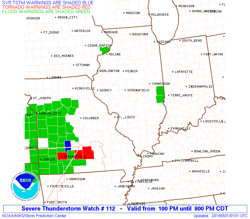
Severe Thunderstorm Watch Number 112
NWS Storm Prediction Center Norman OK
100 PM CDT Tue Apr 30 2019
The NWS Storm Prediction Center has issued a
* Severe Thunderstorm Watch for portions of
Central Illinois
East Central Missouri
* Effective this Tuesday afternoon and evening from 100 PM until
800 PM CDT.
* Primary threats include...
Scattered large hail likely with isolated very large hail events
to 2 inches in diameter possible
Scattered damaging wind gusts to 70 mph likely
A tornado or two possible
SUMMARY...Thunderstorms over east-central Missouri will increase in
coverage and spread across the watch area this afternoon. The
strongest cells will pose a risk of large hail and damaging winds.
An isolated tornado or two is also possible.
The severe thunderstorm watch area is approximately along and 50
statute miles north and south of a line from 50 miles west southwest
of Saint Louis MO to 30 miles south of Danville IL. For a complete
depiction of the watch see the associated watch outline update
(WOUS64 KWNS WOU2).
PRECAUTIONARY/PREPAREDNESS ACTIONS...
REMEMBER...A Severe Thunderstorm Watch means conditions are
favorable for severe thunderstorms in and close to the watch area.
Persons in these areas should be on the lookout for threatening
weather conditions and listen for later statements and possible
warnings. Severe thunderstorms can and occasionally do produce
tornadoes.
&&
OTHER WATCH INFORMATION...CONTINUE...WW 111...
AVIATION...A few severe thunderstorms with hail surface and aloft to
2 inches. Extreme turbulence and surface wind gusts to 60 knots. A
few cumulonimbi with maximum tops to 500. Mean storm motion vector
24035.
...Hart
 Note:
The Aviation Watch (SAW) product is an approximation to the watch area.
The actual watch is depicted by the shaded areas.
Note:
The Aviation Watch (SAW) product is an approximation to the watch area.
The actual watch is depicted by the shaded areas.
   SAW2
   WW 112 SEVERE TSTM IL MO 301800Z - 010100Z
   AXIS..50 STATUTE MILES NORTH AND SOUTH OF LINE..
   50WSW STL/SAINT LOUIS MO/ - 30S DNV/DANVILLE IL/
   ..AVIATION COORDS.. 45NM N/S /42WSW STL - 23NW TTH/
   HAIL SURFACE AND ALOFT..2 INCHES. WIND GUSTS..60 KNOTS.
   MAX TOPS TO 500. MEAN STORM MOTION VECTOR 24035.

   LAT...LON 39189122 40498759 39048759 37759122

   THIS IS AN APPROXIMATION TO THE WATCH AREA.  FOR A
   COMPLETE DEPICTION OF THE WATCH SEE WOUS64 KWNS
   FOR WOU2.
Watch 112 Status Report Messages:
STATUS REPORT #5 ON WW 112

VALID 302320Z - 010040Z

SEVERE WEATHER THREAT CONTINUES RIGHT OF A LINE FROM 45 W STL TO
20 SSE DEC TO 20 NNE CMI.

..SPC..04/30/19

ATTN...WFO...LSX...ILX...

&&

STATUS REPORT FOR WS 112

SEVERE WEATHER THREAT CONTINUES FOR THE FOLLOWING AREAS

ILC005-019-023-025-027-029-035-041-045-049-051-079-119-121-133-
135-139-157-163-173-183-189-010040-

IL
.    ILLINOIS COUNTIES INCLUDED ARE

BOND		     CHAMPAIGN		 CLARK
CLAY		     CLINTON		 COLES
CUMBERLAND	     DOUGLAS		 EDGAR
EFFINGHAM	     FAYETTE		 JASPER
MADISON 	     MARION		 MONROE
MONTGOMERY	     MOULTRIE		 RANDOLPH
ST. CLAIR	     SHELBY		 VERMILION
WASHINGTON
$$


MOC055-071-099-183-186-187-189-219-221-510-010040-

MO
.    MISSOURI COUNTIES INCLUDED ARE

CRAWFORD	     FRANKLIN		 JEFFERSON
ST. CHARLES	     STE. GENEVIEVE	 ST. FRANCOIS
ST. LOUIS	     WARREN		 WASHINGTON


MISSOURI INDEPENDENT CITIES INCLUDED ARE

ST. LOUIS CITY
$$


THE WATCH STATUS MESSAGE IS FOR GUIDANCE PURPOSES ONLY.  PLEASE
REFER TO WATCH COUNTY NOTIFICATION STATEMENTS FOR OFFICIAL
INFORMATION ON COUNTIES...INDEPENDENT CITIES AND MARINE ZONES
CLEARED FROM SEVERE THUNDERSTORM AND TORNADO WATCHES.
$$

STATUS REPORT #4 ON WW 112

VALID 302235Z - 302340Z

SEVERE WEATHER THREAT CONTINUES RIGHT OF A LINE FROM 45 WNW STL
TO 25 NNE ALN TO 25 SSW DEC TO 20 NNE DEC.

..SPC..04/30/19

ATTN...WFO...LSX...ILX...

&&

STATUS REPORT FOR WS 112

SEVERE WEATHER THREAT CONTINUES FOR THE FOLLOWING AREAS

ILC005-013-019-021-023-025-027-029-035-041-045-049-051-079-083-
115-117-119-121-133-135-139-147-157-163-173-183-189-302340-

IL
.    ILLINOIS COUNTIES INCLUDED ARE

BOND		     CALHOUN		 CHAMPAIGN
CHRISTIAN	     CLARK		 CLAY
CLINTON 	     COLES		 CUMBERLAND
DOUGLAS 	     EDGAR		 EFFINGHAM
FAYETTE 	     JASPER		 JERSEY
MACON		     MACOUPIN		 MADISON
MARION		     MONROE		 MONTGOMERY
MOULTRIE	     PIATT		 RANDOLPH
ST. CLAIR	     SHELBY		 VERMILION
WASHINGTON
$$


MOC055-071-099-183-186-187-189-219-221-510-302340-

MO
.    MISSOURI COUNTIES INCLUDED ARE

CRAWFORD	     FRANKLIN		 JEFFERSON
ST. CHARLES	     STE. GENEVIEVE	 ST. FRANCOIS
ST. LOUIS	     WARREN		 WASHINGTON


MISSOURI INDEPENDENT CITIES INCLUDED ARE

ST. LOUIS CITY
$$


THE WATCH STATUS MESSAGE IS FOR GUIDANCE PURPOSES ONLY.  PLEASE
REFER TO WATCH COUNTY NOTIFICATION STATEMENTS FOR OFFICIAL
INFORMATION ON COUNTIES...INDEPENDENT CITIES AND MARINE ZONES
CLEARED FROM SEVERE THUNDERSTORM AND TORNADO WATCHES.
$$

STATUS REPORT #3 ON WW 112

VALID 302040Z - 302140Z

THE SEVERE WEATHER THREAT CONTINUES ACROSS THE ENTIRE WATCH AREA.

..BROYLES..04/30/19

ATTN...WFO...LSX...ILX...

&&

STATUS REPORT FOR WS 112

SEVERE WEATHER THREAT CONTINUES FOR THE FOLLOWING AREAS

ILC005-013-019-021-023-025-027-029-035-041-045-049-051-061-079-
083-115-117-119-121-133-135-137-139-147-157-163-167-171-173-183-
189-302140-

IL
.    ILLINOIS COUNTIES INCLUDED ARE

BOND		     CALHOUN		 CHAMPAIGN
CHRISTIAN	     CLARK		 CLAY
CLINTON 	     COLES		 CUMBERLAND
DOUGLAS 	     EDGAR		 EFFINGHAM
FAYETTE 	     GREENE		 JASPER
JERSEY		     MACON		 MACOUPIN
MADISON 	     MARION		 MONROE
MONTGOMERY	     MORGAN		 MOULTRIE
PIATT		     RANDOLPH		 ST. CLAIR
SANGAMON	     SCOTT		 SHELBY
VERMILION	     WASHINGTON
$$


MOC055-071-099-113-183-186-187-189-219-221-510-302140-

MO
.    MISSOURI COUNTIES INCLUDED ARE

CRAWFORD	     FRANKLIN		 JEFFERSON
LINCOLN 	     ST. CHARLES	 STE. GENEVIEVE
ST. FRANCOIS	     ST. LOUIS		 WARREN
WASHINGTON


MISSOURI INDEPENDENT CITIES INCLUDED ARE

ST. LOUIS CITY
$$


THE WATCH STATUS MESSAGE IS FOR GUIDANCE PURPOSES ONLY.  PLEASE
REFER TO WATCH COUNTY NOTIFICATION STATEMENTS FOR OFFICIAL
INFORMATION ON COUNTIES...INDEPENDENT CITIES AND MARINE ZONES
CLEARED FROM SEVERE THUNDERSTORM AND TORNADO WATCHES.
$$

STATUS REPORT #2 ON WW 112

VALID 301945Z - 302040Z

THE SEVERE WEATHER THREAT CONTINUES ACROSS THE ENTIRE WATCH AREA.

..BROYLES..04/30/19

ATTN...WFO...LSX...ILX...

&&

STATUS REPORT FOR WS 112

SEVERE WEATHER THREAT CONTINUES FOR THE FOLLOWING AREAS

ILC005-013-019-021-023-025-027-029-035-041-045-049-051-061-079-
083-115-117-119-121-133-135-137-139-147-157-163-167-171-173-183-
189-302040-

IL
.    ILLINOIS COUNTIES INCLUDED ARE

BOND		     CALHOUN		 CHAMPAIGN
CHRISTIAN	     CLARK		 CLAY
CLINTON 	     COLES		 CUMBERLAND
DOUGLAS 	     EDGAR		 EFFINGHAM
FAYETTE 	     GREENE		 JASPER
JERSEY		     MACON		 MACOUPIN
MADISON 	     MARION		 MONROE
MONTGOMERY	     MORGAN		 MOULTRIE
PIATT		     RANDOLPH		 ST. CLAIR
SANGAMON	     SCOTT		 SHELBY
VERMILION	     WASHINGTON
$$


MOC055-071-099-113-183-186-187-189-219-221-510-302040-

MO
.    MISSOURI COUNTIES INCLUDED ARE

CRAWFORD	     FRANKLIN		 JEFFERSON
LINCOLN 	     ST. CHARLES	 STE. GENEVIEVE
ST. FRANCOIS	     ST. LOUIS		 WARREN
WASHINGTON


MISSOURI INDEPENDENT CITIES INCLUDED ARE

ST. LOUIS CITY
$$


THE WATCH STATUS MESSAGE IS FOR GUIDANCE PURPOSES ONLY.  PLEASE
REFER TO WATCH COUNTY NOTIFICATION STATEMENTS FOR OFFICIAL
INFORMATION ON COUNTIES...INDEPENDENT CITIES AND MARINE ZONES
CLEARED FROM SEVERE THUNDERSTORM AND TORNADO WATCHES.
$$

STATUS REPORT #1 ON WW 112

VALID 301825Z - 301940Z

THE SEVERE WEATHER THREAT CONTINUES ACROSS THE ENTIRE WATCH AREA.

..BROYLES..04/30/19

ATTN...WFO...LSX...ILX...

&&

STATUS REPORT FOR WS 112

SEVERE WEATHER THREAT CONTINUES FOR THE FOLLOWING AREAS

ILC005-013-019-021-023-025-027-029-035-041-045-049-051-061-079-
083-115-117-119-121-133-135-137-139-147-157-163-167-171-173-183-
189-301940-

IL
.    ILLINOIS COUNTIES INCLUDED ARE

BOND		     CALHOUN		 CHAMPAIGN
CHRISTIAN	     CLARK		 CLAY
CLINTON 	     COLES		 CUMBERLAND
DOUGLAS 	     EDGAR		 EFFINGHAM
FAYETTE 	     GREENE		 JASPER
JERSEY		     MACON		 MACOUPIN
MADISON 	     MARION		 MONROE
MONTGOMERY	     MORGAN		 MOULTRIE
PIATT		     RANDOLPH		 ST. CLAIR
SANGAMON	     SCOTT		 SHELBY
VERMILION	     WASHINGTON
$$


MOC055-071-099-113-183-186-187-189-219-221-510-301940-

MO
.    MISSOURI COUNTIES INCLUDED ARE

CRAWFORD	     FRANKLIN		 JEFFERSON
LINCOLN 	     ST. CHARLES	 STE. GENEVIEVE
ST. FRANCOIS	     ST. LOUIS		 WARREN
WASHINGTON


MISSOURI INDEPENDENT CITIES INCLUDED ARE

ST. LOUIS CITY
$$


THE WATCH STATUS MESSAGE IS FOR GUIDANCE PURPOSES ONLY.  PLEASE
REFER TO WATCH COUNTY NOTIFICATION STATEMENTS FOR OFFICIAL
INFORMATION ON COUNTIES...INDEPENDENT CITIES AND MARINE ZONES
CLEARED FROM SEVERE THUNDERSTORM AND TORNADO WATCHES.
$$
Note:
Click for Complete Product Text.
Tornadoes
Probability of 2 or more tornadoes
|
Low (20%)
|
Probability of 1 or more strong (EF2-EF5) tornadoes
|
Low (10%)
|
Wind
Probability of 10 or more severe wind events
|
Mod (60%)
|
Probability of 1 or more wind events > 65 knots
|
Low (20%)
|
Hail
Probability of 10 or more severe hail events
|
High (70%)
|
Probability of 1 or more hailstones > 2 inches
|
Mod (30%)
|
Combined Severe Hail/Wind
Probability of 6 or more combined severe hail/wind events
|
High (90%)
|
For each watch, probabilities for particular events inside the watch
(listed above in each table) are determined by the issuing forecaster.
The "Low" category contains probability values ranging from less than 2%
to 20% (EF2-EF5 tornadoes), less than 5% to 20% (all other probabilities),
"Moderate" from 30% to 60%, and "High" from 70% to greater than 95%.
High values are bolded and lighter in color to provide awareness of
an increased threat for a particular event.


 @NWSSPC