 Note:
The expiration time in the watch graphic is amended if the watch is
replaced, cancelled or extended.
Note:
Note:
The expiration time in the watch graphic is amended if the watch is
replaced, cancelled or extended.
Note: Click for
Watch Status Reports.
SEL7
URGENT - IMMEDIATE BROADCAST REQUESTED
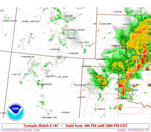
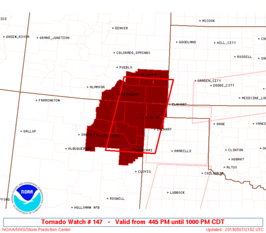
Tornado Watch Number 147
NWS Storm Prediction Center Norman OK
445 PM CDT Tue May 7 2019
The NWS Storm Prediction Center has issued a
* Tornado Watch for portions of
Southeast Colorado
Northeast New Mexico
Far Western Oklahoma Panhandle
Far Northwestern Texas Panhandle
* Effective this Tuesday afternoon and evening from 445 PM until
1000 PM CDT.
* Primary threats include...
A couple tornadoes possible
Scattered large hail and isolated very large hail events to 2.5
inches in diameter possible
Isolated damaging wind gusts to 65 mph possible
SUMMARY...Isolated to scattered thunderstorms should develop across
northeast New Mexico and spread northeast through the early evening.
Large hail and a couple tornadoes are the primary hazards.
The tornado watch area is approximately along and 65 statute miles
east and west of a line from 5 miles south southwest of Tucumcari NM
to 50 miles north northwest of Springfield CO. For a complete
depiction of the watch see the associated watch outline update
(WOUS64 KWNS WOU7).
PRECAUTIONARY/PREPAREDNESS ACTIONS...
REMEMBER...A Tornado Watch means conditions are favorable for
tornadoes and severe thunderstorms in and close to the watch
area. Persons in these areas should be on the lookout for
threatening weather conditions and listen for later statements
and possible warnings.
&&
OTHER WATCH INFORMATION...CONTINUE...WW 144...WW 145...WW 146...
AVIATION...Tornadoes and a few severe thunderstorms with hail
surface and aloft to 2.5 inches. Extreme turbulence and surface wind
gusts to 55 knots. A few cumulonimbi with maximum tops to 400. Mean
storm motion vector 21030.
...Grams
 Note:
The Aviation Watch (SAW) product is an approximation to the watch area.
The actual watch is depicted by the shaded areas.
Note:
The Aviation Watch (SAW) product is an approximation to the watch area.
The actual watch is depicted by the shaded areas.
   SAW7
   WW 147 TORNADO CO NM OK TX 072145Z - 080300Z
   AXIS..65 STATUTE MILES EAST AND WEST OF LINE..
   5SSW TCC/TUCUMCARI NM/ - 50NNW SPD/SPRINGFIELD CO/
   ..AVIATION COORDS.. 55NM E/W /4SSW TCC - 20SW LAA/
   HAIL SURFACE AND ALOFT..2.5 INCHES. WIND GUSTS..55 KNOTS.
   MAX TOPS TO 400. MEAN STORM MOTION VECTOR 21030.

   LAT...LON 35110477 37930416 37930177 35110248

   THIS IS AN APPROXIMATION TO THE WATCH AREA.  FOR A
   COMPLETE DEPICTION OF THE WATCH SEE WOUS64 KWNS
   FOR WOU7.
Watch 147 Status Report Messages:
STATUS REPORT #4 ON WW 147

VALID 080050Z - 080140Z

SEVERE WEATHER THREAT CONTINUES RIGHT OF A LINE FROM 25 NNW CVS
TO 20 NNW TCC TO 60 SSE RTN TO 10 NNE RTN TO 30 W TAD.

..BENTLEY..05/08/19

ATTN...WFO...PUB...ABQ...AMA...

&&

STATUS REPORT FOR WT 147

SEVERE WEATHER THREAT CONTINUES FOR THE FOLLOWING AREAS

COC009-011-071-089-099-080140-

CO
.    COLORADO COUNTIES INCLUDED ARE

BACA		     BENT		 LAS ANIMAS
OTERO		     PROWERS
$$


NMC021-037-059-080140-

NM
.    NEW MEXICO COUNTIES INCLUDED ARE

HARDING 	     QUAY		 UNION
$$


OKC025-080140-

OK
.    OKLAHOMA COUNTIES INCLUDED ARE

CIMARRON
$$


TXC111-080140-

TX
.    TEXAS COUNTIES INCLUDED ARE

DALLAM
$$


THE WATCH STATUS MESSAGE IS FOR GUIDANCE PURPOSES ONLY.  PLEASE
REFER TO WATCH COUNTY NOTIFICATION STATEMENTS FOR OFFICIAL
INFORMATION ON COUNTIES...INDEPENDENT CITIES AND MARINE ZONES
CLEARED FROM SEVERE THUNDERSTORM AND TORNADO WATCHES.
$$

STATUS REPORT #3 ON WW 147

VALID 080050Z - 080140Z

SEVERE WEATHER THREAT CONTINUES RIGHT OF A LINE FROM 25 NNW CVS
TO 20 NNW TCC TO 60 SSE RTN TO 10 NNE RTN TO 30 W TAD.

..BENTLEY..05/08/19

ATTN...WFO...PUB...ABQ...AMA...

&&

STATUS REPORT FOR WT 147

SEVERE WEATHER THREAT CONTINUES FOR THE FOLLOWING AREAS

COC009-011-071-089-099-080140-

CO
.    COLORADO COUNTIES INCLUDED ARE

BACA		     BENT		 LAS ANIMAS
OTERO		     PROWERS
$$


NMC021-037-059-080140-

NM
.    NEW MEXICO COUNTIES INCLUDED ARE

HARDING 	     QUAY		 UNION
$$


OKC025-080140-

OK
.    OKLAHOMA COUNTIES INCLUDED ARE

CIMARRON
$$


TXC111-080140-

TX
.    TEXAS COUNTIES INCLUDED ARE

DALLAM
$$


THE WATCH STATUS MESSAGE IS FOR GUIDANCE PURPOSES ONLY.  PLEASE
REFER TO WATCH COUNTY NOTIFICATION STATEMENTS FOR OFFICIAL
INFORMATION ON COUNTIES...INDEPENDENT CITIES AND MARINE ZONES
CLEARED FROM SEVERE THUNDERSTORM AND TORNADO WATCHES.
$$

STATUS REPORT #2 ON WW 147

VALID 072335Z - 080040Z

SEVERE WEATHER THREAT CONTINUES RIGHT OF A LINE FROM 25 NW CVS TO
15 WNW TCC TO 45 E LVS TO 35 NNE LVS.

..BENTLEY..05/07/19

ATTN...WFO...PUB...ABQ...AMA...

&&

STATUS REPORT FOR WT 147

SEVERE WEATHER THREAT CONTINUES FOR THE FOLLOWING AREAS

COC009-011-071-089-099-080040-

CO
.    COLORADO COUNTIES INCLUDED ARE

BACA		     BENT		 LAS ANIMAS
OTERO		     PROWERS
$$


NMC007-021-033-037-047-059-080040-

NM
.    NEW MEXICO COUNTIES INCLUDED ARE

COLFAX		     HARDING		 MORA
QUAY		     SAN MIGUEL 	 UNION
$$


OKC025-080040-

OK
.    OKLAHOMA COUNTIES INCLUDED ARE

CIMARRON
$$


TXC111-080040-

TX
.    TEXAS COUNTIES INCLUDED ARE

DALLAM
$$


THE WATCH STATUS MESSAGE IS FOR GUIDANCE PURPOSES ONLY.  PLEASE
REFER TO WATCH COUNTY NOTIFICATION STATEMENTS FOR OFFICIAL
INFORMATION ON COUNTIES...INDEPENDENT CITIES AND MARINE ZONES
CLEARED FROM SEVERE THUNDERSTORM AND TORNADO WATCHES.
$$

STATUS REPORT #1 ON WW 147

VALID 072250Z - 072340Z

THE SEVERE WEATHER THREAT CONTINUES ACROSS THE ENTIRE WATCH AREA.

..BENTLEY..05/07/19

ATTN...WFO...PUB...ABQ...AMA...

&&

STATUS REPORT FOR WT 147

SEVERE WEATHER THREAT CONTINUES FOR THE FOLLOWING AREAS

COC009-011-071-089-099-072340-

CO
.    COLORADO COUNTIES INCLUDED ARE

BACA		     BENT		 LAS ANIMAS
OTERO		     PROWERS
$$


NMC007-021-033-037-047-059-072340-

NM
.    NEW MEXICO COUNTIES INCLUDED ARE

COLFAX		     HARDING		 MORA
QUAY		     SAN MIGUEL 	 UNION
$$


OKC025-072340-

OK
.    OKLAHOMA COUNTIES INCLUDED ARE

CIMARRON
$$


TXC111-072340-

TX
.    TEXAS COUNTIES INCLUDED ARE

DALLAM
$$


THE WATCH STATUS MESSAGE IS FOR GUIDANCE PURPOSES ONLY.  PLEASE
REFER TO WATCH COUNTY NOTIFICATION STATEMENTS FOR OFFICIAL
INFORMATION ON COUNTIES...INDEPENDENT CITIES AND MARINE ZONES
CLEARED FROM SEVERE THUNDERSTORM AND TORNADO WATCHES.
$$
Note:
Click for Complete Product Text.
Tornadoes
Probability of 2 or more tornadoes
|
Mod (40%)
|
Probability of 1 or more strong (EF2-EF5) tornadoes
|
Low (10%)
|
Wind
Probability of 10 or more severe wind events
|
Low (20%)
|
Probability of 1 or more wind events > 65 knots
|
Low (10%)
|
Hail
Probability of 10 or more severe hail events
|
Mod (40%)
|
Probability of 1 or more hailstones > 2 inches
|
Mod (30%)
|
Combined Severe Hail/Wind
Probability of 6 or more combined severe hail/wind events
|
Mod (50%)
|
For each watch, probabilities for particular events inside the watch
(listed above in each table) are determined by the issuing forecaster.
The "Low" category contains probability values ranging from less than 2%
to 20% (EF2-EF5 tornadoes), less than 5% to 20% (all other probabilities),
"Moderate" from 30% to 60%, and "High" from 70% to greater than 95%.
High values are bolded and lighter in color to provide awareness of
an increased threat for a particular event.


 @NWSSPC


