 Note:
The expiration time in the watch graphic is amended if the watch is
replaced, cancelled or extended.
Note:
Note:
The expiration time in the watch graphic is amended if the watch is
replaced, cancelled or extended.
Note: Click for
Watch Status Reports.
SEL7
URGENT - IMMEDIATE BROADCAST REQUESTED
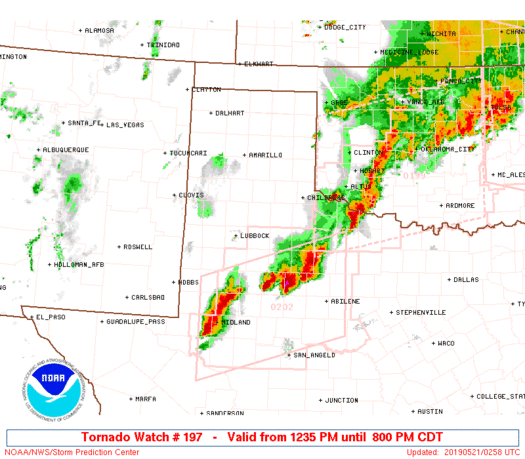
Tornado Watch Number 197
NWS Storm Prediction Center Norman OK
1235 PM CDT Mon May 20 2019
The NWS Storm Prediction Center has issued a
* Tornado Watch for portions of
West Texas including much of the Panhandle
* Effective this Monday afternoon and evening from 1235 PM until
800 PM CDT.
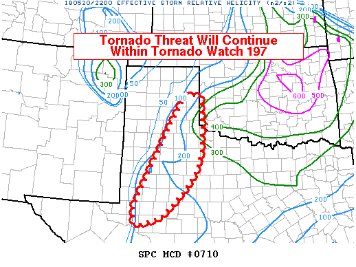
...THIS IS A PARTICULARLY DANGEROUS SITUATION...
* Primary threats include...
Numerous tornadoes expected with a few intense tornadoes likely
Widespread large hail and scattered very large hail events to 4
inches in diameter expected
Widespread damaging wind gusts to 70 mph likely
SUMMARY...Intense tornadic supercell thunderstorms are expected to
develop across west Texas as the eastern half of the Texas
Panhandle. In addition to the risk of strong tornadoes, very large
hail and damaging winds are likely in the strongest cells.
The tornado watch area is approximately along and 55 statute miles
east and west of a line from 50 miles east northeast of Amarillo TX
to 35 miles east of Big Spring TX. For a complete depiction of the
watch see the associated watch outline update (WOUS64 KWNS WOU7).
PRECAUTIONARY/PREPAREDNESS ACTIONS...
REMEMBER...A Tornado Watch means conditions are favorable for
tornadoes and severe thunderstorms in and close to the watch
area. Persons in these areas should be on the lookout for
threatening weather conditions and listen for later statements
and possible warnings.
&&
OTHER WATCH INFORMATION...CONTINUE...WW 196...
AVIATION...Tornadoes and a few severe thunderstorms with hail
surface and aloft to 4 inches. Extreme turbulence and surface wind
gusts to 60 knots. A few cumulonimbi with maximum tops to 600. Mean
storm motion vector 24035.
...Hart

   SEL7

   URGENT - IMMEDIATE BROADCAST REQUESTED
   Tornado Watch Number 197
   NWS Storm Prediction Center Norman OK
   1235 PM CDT Mon May 20 2019

   The NWS Storm Prediction Center has issued a

   * Tornado Watch for portions of
     West Texas including much of the Panhandle

   * Effective this Monday afternoon and evening from 1235 PM until
     800 PM CDT.

   ...THIS IS A PARTICULARLY DANGEROUS SITUATION...

   * Primary threats include...
     Numerous tornadoes expected with a few intense tornadoes likely
     Widespread large hail and scattered very large hail events to 4
       inches in diameter expected
     Widespread damaging wind gusts to 70 mph likely

   SUMMARY...Intense tornadic supercell thunderstorms are expected to
   develop across west Texas as the eastern half of the Texas
   Panhandle.  In addition to the risk of strong tornadoes, very large
   hail and damaging winds are likely in the strongest cells.

   The tornado watch area is approximately along and 55 statute miles
   east and west of a line from 50 miles east northeast of Amarillo TX
   to 35 miles east of Big Spring TX. For a complete depiction of the
   watch see the associated watch outline update (WOUS64 KWNS WOU7).

   PRECAUTIONARY/PREPAREDNESS ACTIONS...

   REMEMBER...A Tornado Watch means conditions are favorable for
   tornadoes and severe thunderstorms in and close to the watch
   area. Persons in these areas should be on the lookout for
   threatening weather conditions and listen for later statements
   and possible warnings.

   &&

   OTHER WATCH INFORMATION...CONTINUE...WW 196...

   AVIATION...Tornadoes and a few severe thunderstorms with hail
   surface and aloft to 4 inches. Extreme turbulence and surface wind
   gusts to 60 knots. A few cumulonimbi with maximum tops to 600. Mean
   storm motion vector 24035.

   ...Hart
 Note:
The Aviation Watch (SAW) product is an approximation to the watch area.
The actual watch is depicted by the shaded areas.
Note:
The Aviation Watch (SAW) product is an approximation to the watch area.
The actual watch is depicted by the shaded areas.
   SAW7
   WW 197 TORNADO TX 201735Z - 210100Z
   AXIS..55 STATUTE MILES EAST AND WEST OF LINE..
   50ENE AMA/AMARILLO TX/ - 35E BGS/BIG SPRING TX/
   ..AVIATION COORDS.. 50NM E/W /38ENE AMA - 55WSW ABI/
   HAIL SURFACE AND ALOFT..4 INCHES. WIND GUSTS..60 KNOTS.
   MAX TOPS TO 600. MEAN STORM MOTION VECTOR 24035.

   LAT...LON 35499991 32229995 32220183 35490187

   THIS IS AN APPROXIMATION TO THE WATCH AREA.  FOR A
   COMPLETE DEPICTION OF THE WATCH SEE WOUS64 KWNS
   FOR WOU7.
Watch 197 Status Report Messages:
STATUS REPORT #5 ON WW 197

VALID 202245Z - 202340Z

SEVERE WEATHER THREAT CONTINUES RIGHT OF A LINE FROM 15 NW PVW TO
40 ESE BGD.

..MARSH..05/20/19

ATTN...WFO...AMA...MAF...LUB...SJT...

&&

STATUS REPORT FOR WT 197

SEVERE WEATHER THREAT CONTINUES FOR THE FOLLOWING AREAS

TXC011-033-045-075-087-101-103-107-115-125-129-135-151-153-169-
173-179-189-191-207-227-253-263-269-303-305-317-329-335-345-353-
383-415-433-437-441-461-483-202340-

TX
.    TEXAS COUNTIES INCLUDED ARE

ARMSTRONG	     BORDEN		 BRISCOE
CHILDRESS	     COLLINGSWORTH	 COTTLE
CRANE		     CROSBY		 DAWSON
DICKENS 	     DONLEY		 ECTOR
FISHER		     FLOYD		 GARZA
GLASSCOCK	     GRAY		 HALE
HALL		     HASKELL		 HOWARD
JONES		     KENT		 KING
LUBBOCK 	     LYNN		 MARTIN
MIDLAND 	     MITCHELL		 MOTLEY
NOLAN		     REAGAN		 SCURRY
STONEWALL	     SWISHER		 TAYLOR
UPTON		     WHEELER
$$


THE WATCH STATUS MESSAGE IS FOR GUIDANCE PURPOSES ONLY.  PLEASE
REFER TO WATCH COUNTY NOTIFICATION STATEMENTS FOR OFFICIAL
INFORMATION ON COUNTIES...INDEPENDENT CITIES AND MARINE ZONES
CLEARED FROM SEVERE THUNDERSTORM AND TORNADO WATCHES.
$$

STATUS REPORT #4 ON WW 197

VALID 202140Z - 202240Z

SEVERE WEATHER THREAT CONTINUES RIGHT OF A LINE FROM 15 NW PVW TO
40 ESE BGD.

..MARSH..05/20/19

ATTN...WFO...AMA...MAF...LUB...SJT...

&&

STATUS REPORT FOR WT 197

SEVERE WEATHER THREAT CONTINUES FOR THE FOLLOWING AREAS

TXC011-033-045-075-087-101-107-115-125-129-151-153-169-179-189-
191-207-227-253-263-269-303-305-317-335-345-353-415-433-437-441-
483-202240-

TX
.    TEXAS COUNTIES INCLUDED ARE

ARMSTRONG	     BORDEN		 BRISCOE
CHILDRESS	     COLLINGSWORTH	 COTTLE
CROSBY		     DAWSON		 DICKENS
DONLEY		     FISHER		 FLOYD
GARZA		     GRAY		 HALE
HALL		     HASKELL		 HOWARD
JONES		     KENT		 KING
LUBBOCK 	     LYNN		 MARTIN
MITCHELL	     MOTLEY		 NOLAN
SCURRY		     STONEWALL		 SWISHER
TAYLOR		     WHEELER
$$


THE WATCH STATUS MESSAGE IS FOR GUIDANCE PURPOSES ONLY.  PLEASE
REFER TO WATCH COUNTY NOTIFICATION STATEMENTS FOR OFFICIAL
INFORMATION ON COUNTIES...INDEPENDENT CITIES AND MARINE ZONES
CLEARED FROM SEVERE THUNDERSTORM AND TORNADO WATCHES.
$$

STATUS REPORT #3 ON WW 197

VALID 202040Z - 202140Z

SEVERE WEATHER THREAT CONTINUES RIGHT OF A LINE FROM 30 NNW PVW
TO 25 SE BGD.

..MARSH..05/20/19

ATTN...WFO...AMA...MAF...LUB...SJT...

&&

STATUS REPORT FOR WT 197

SEVERE WEATHER THREAT CONTINUES FOR THE FOLLOWING AREAS

TXC011-033-045-075-087-101-107-115-125-129-151-153-169-179-189-
191-207-227-253-263-269-303-305-317-335-345-353-415-433-437-441-
483-202140-

TX
.    TEXAS COUNTIES INCLUDED ARE

ARMSTRONG	     BORDEN		 BRISCOE
CHILDRESS	     COLLINGSWORTH	 COTTLE
CROSBY		     DAWSON		 DICKENS
DONLEY		     FISHER		 FLOYD
GARZA		     GRAY		 HALE
HALL		     HASKELL		 HOWARD
JONES		     KENT		 KING
LUBBOCK 	     LYNN		 MARTIN
MITCHELL	     MOTLEY		 NOLAN
SCURRY		     STONEWALL		 SWISHER
TAYLOR		     WHEELER
$$


THE WATCH STATUS MESSAGE IS FOR GUIDANCE PURPOSES ONLY.  PLEASE
REFER TO WATCH COUNTY NOTIFICATION STATEMENTS FOR OFFICIAL
INFORMATION ON COUNTIES...INDEPENDENT CITIES AND MARINE ZONES
CLEARED FROM SEVERE THUNDERSTORM AND TORNADO WATCHES.
$$

STATUS REPORT #2 ON WW 197

VALID 201940Z - 202040Z

THE SEVERE WEATHER THREAT CONTINUES ACROSS THE ENTIRE WATCH AREA.

..MARSH..05/20/19

ATTN...WFO...AMA...MAF...LUB...SJT...

&&

STATUS REPORT FOR WT 197

SEVERE WEATHER THREAT CONTINUES FOR THE FOLLOWING AREAS

TXC011-033-045-065-075-087-101-107-115-125-129-151-153-169-179-
189-191-207-211-227-253-263-269-303-305-317-335-345-353-375-381-
393-415-433-437-441-483-202040-

TX
.    TEXAS COUNTIES INCLUDED ARE

ARMSTRONG	     BORDEN		 BRISCOE
CARSON		     CHILDRESS		 COLLINGSWORTH
COTTLE		     CROSBY		 DAWSON
DICKENS 	     DONLEY		 FISHER
FLOYD		     GARZA		 GRAY
HALE		     HALL		 HASKELL
HEMPHILL	     HOWARD		 JONES
KENT		     KING		 LUBBOCK
LYNN		     MARTIN		 MITCHELL
MOTLEY		     NOLAN		 POTTER
RANDALL 	     ROBERTS		 SCURRY
STONEWALL	     SWISHER		 TAYLOR
WHEELER
$$


THE WATCH STATUS MESSAGE IS FOR GUIDANCE PURPOSES ONLY.  PLEASE
REFER TO WATCH COUNTY NOTIFICATION STATEMENTS FOR OFFICIAL
INFORMATION ON COUNTIES...INDEPENDENT CITIES AND MARINE ZONES
CLEARED FROM SEVERE THUNDERSTORM AND TORNADO WATCHES.
$$

STATUS REPORT #1 ON WW 197

VALID 201850Z - 201940Z

THE SEVERE WEATHER THREAT CONTINUES ACROSS THE ENTIRE WATCH AREA.

..MARSH..05/20/19

ATTN...WFO...AMA...MAF...LUB...SJT...

&&

STATUS REPORT FOR WT 197

SEVERE WEATHER THREAT CONTINUES FOR THE FOLLOWING AREAS

TXC011-033-045-065-075-087-101-107-115-125-129-151-153-169-179-
189-191-207-211-227-253-263-269-303-305-317-335-345-353-375-381-
393-415-433-437-441-483-201940-

TX
.    TEXAS COUNTIES INCLUDED ARE

ARMSTRONG	     BORDEN		 BRISCOE
CARSON		     CHILDRESS		 COLLINGSWORTH
COTTLE		     CROSBY		 DAWSON
DICKENS 	     DONLEY		 FISHER
FLOYD		     GARZA		 GRAY
HALE		     HALL		 HASKELL
HEMPHILL	     HOWARD		 JONES
KENT		     KING		 LUBBOCK
LYNN		     MARTIN		 MITCHELL
MOTLEY		     NOLAN		 POTTER
RANDALL 	     ROBERTS		 SCURRY
STONEWALL	     SWISHER		 TAYLOR
WHEELER
$$


THE WATCH STATUS MESSAGE IS FOR GUIDANCE PURPOSES ONLY.  PLEASE
REFER TO WATCH COUNTY NOTIFICATION STATEMENTS FOR OFFICIAL
INFORMATION ON COUNTIES...INDEPENDENT CITIES AND MARINE ZONES
CLEARED FROM SEVERE THUNDERSTORM AND TORNADO WATCHES.
$$
Note:
Click for Complete Product Text.
Tornadoes
Probability of 2 or more tornadoes
|
High (>95%)
|
Probability of 1 or more strong (EF2-EF5) tornadoes
|
High (90%)
|
Wind
Probability of 10 or more severe wind events
|
High (80%)
|
Probability of 1 or more wind events > 65 knots
|
Low (20%)
|
Hail
Probability of 10 or more severe hail events
|
High (>95%)
|
Probability of 1 or more hailstones > 2 inches
|
High (>95%)
|
Combined Severe Hail/Wind
Probability of 6 or more combined severe hail/wind events
|
High (>95%)
|
For each watch, probabilities for particular events inside the watch
(listed above in each table) are determined by the issuing forecaster.
The "Low" category contains probability values ranging from less than 2%
to 20% (EF2-EF5 tornadoes), less than 5% to 20% (all other probabilities),
"Moderate" from 30% to 60%, and "High" from 70% to greater than 95%.
High values are bolded and lighter in color to provide awareness of
an increased threat for a particular event.


 @NWSSPC