 Note:
The expiration time in the watch graphic is amended if the watch is
replaced, cancelled or extended.
Note:
Note:
The expiration time in the watch graphic is amended if the watch is
replaced, cancelled or extended.
Note: Click for
Watch Status Reports.
SEL0
URGENT - IMMEDIATE BROADCAST REQUESTED
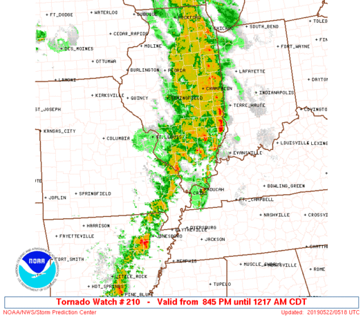
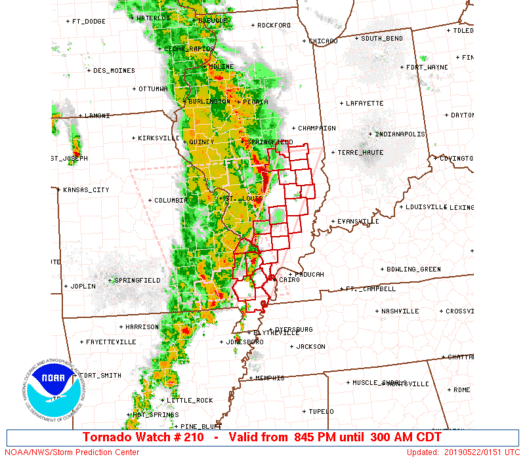
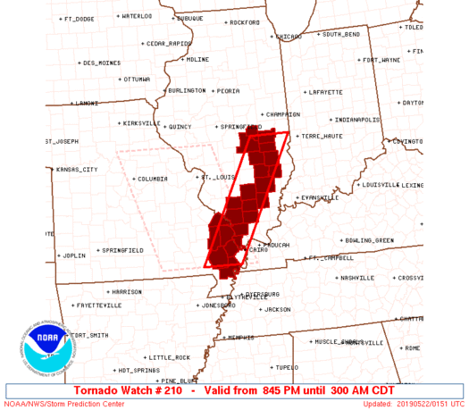
Tornado Watch Number 210
NWS Storm Prediction Center Norman OK
845 PM CDT Tue May 21 2019
The NWS Storm Prediction Center has issued a
* Tornado Watch for portions of
Southern Illinois
Southeast Missouri
* Effective this Tuesday night and Wednesday morning from 845 PM
until 300 AM CDT.
* Primary threats include...
A few tornadoes possible
Scattered damaging wind gusts to 70 mph likely
Isolated large hail events to 1.5 inches in diameter possible
SUMMARY...A broken line/clusters of storms will continue to steadily
progress east-northeastward across southern Illinois and southeast
Missouri through the late evening and overnight hours, with the most
intense storms along and south of a warm front.
The tornado watch area is approximately along and 30 statute miles
east and west of a line from 10 miles northeast of Mattoon IL to 40
miles south southwest of Cape Girardeau MO. For a complete depiction
of the watch see the associated watch outline update (WOUS64 KWNS
WOU0).
PRECAUTIONARY/PREPAREDNESS ACTIONS...
REMEMBER...A Tornado Watch means conditions are favorable for
tornadoes and severe thunderstorms in and close to the watch
area. Persons in these areas should be on the lookout for
threatening weather conditions and listen for later statements
and possible warnings.
&&
OTHER WATCH INFORMATION...CONTINUE...WW 207...WW 208...WW 209...
AVIATION...Tornadoes and a few severe thunderstorms with hail
surface and aloft to 1.5 inches. Extreme turbulence and surface wind
gusts to 60 knots. A few cumulonimbi with maximum tops to 550. Mean
storm motion vector 24035.
...Guyer
   SEL0

   URGENT - IMMEDIATE BROADCAST REQUESTED
   Tornado Watch Number 210
   NWS Storm Prediction Center Norman OK
   845 PM CDT Tue May 21 2019

   The NWS Storm Prediction Center has issued a

   * Tornado Watch for portions of
     Southern Illinois
     Southeast Missouri

   * Effective this Tuesday night and Wednesday morning from 845 PM
     until 300 AM CDT.

   * Primary threats include...
     A few tornadoes possible
     Scattered damaging wind gusts to 70 mph likely
     Isolated large hail events to 1.5 inches in diameter possible

   SUMMARY...A broken line/clusters of storms will continue to steadily
   progress east-northeastward across southern Illinois and southeast
   Missouri through the late evening and overnight hours, with the most
   intense storms along and south of a warm front.

   The tornado watch area is approximately along and 30 statute miles
   east and west of a line from 10 miles northeast of Mattoon IL to 40
   miles south southwest of Cape Girardeau MO. For a complete depiction
   of the watch see the associated watch outline update (WOUS64 KWNS
   WOU0).

   PRECAUTIONARY/PREPAREDNESS ACTIONS...

   REMEMBER...A Tornado Watch means conditions are favorable for
   tornadoes and severe thunderstorms in and close to the watch
   area. Persons in these areas should be on the lookout for
   threatening weather conditions and listen for later statements
   and possible warnings.

   &&

   OTHER WATCH INFORMATION...CONTINUE...WW 207...WW 208...WW 209...

   AVIATION...Tornadoes and a few severe thunderstorms with hail
   surface and aloft to 1.5 inches. Extreme turbulence and surface wind
   gusts to 60 knots. A few cumulonimbi with maximum tops to 550. Mean
   storm motion vector 24035.

   ...Guyer
 Note:
The Aviation Watch (SAW) product is an approximation to the watch area.
The actual watch is depicted by the shaded areas.
Note:
The Aviation Watch (SAW) product is an approximation to the watch area.
The actual watch is depicted by the shaded areas.
   SAW0
   WW 210 TORNADO IL MO 220145Z - 220800Z
   AXIS..30 STATUTE MILES EAST AND WEST OF LINE..
   10NE MTO/MATTOON IL/ - 40SSW CGI/CAPE GIRARDEAU MO/
   ..AVIATION COORDS.. 25NM E/W /34ESE AXC - 47NNW DYR/
   HAIL SURFACE AND ALOFT..1.5 INCHES. WIND GUSTS..60 KNOTS.
   MAX TOPS TO 550. MEAN STORM MOTION VECTOR 24035.

   LAT...LON 39568758 36688930 36689038 39568870

   THIS IS AN APPROXIMATION TO THE WATCH AREA.  FOR A
   COMPLETE DEPICTION OF THE WATCH SEE WOUS64 KWNS
   FOR WOU0.
Watch 210 Status Report Messages:
STATUS REPORT #3 ON WW 210
VALID 220445Z - 220540Z
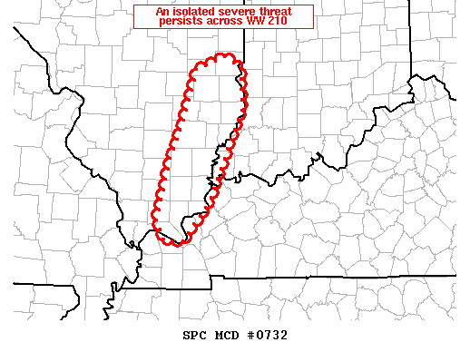
SEVERE WEATHER THREAT CONTINUES RIGHT OF A LINE FROM 20 N PAH TO
15 SE MVN TO 25 SSW MTO TO 20 S CMI.
FOR ADDITIONAL INFORMATION SEE MESOSCALE DISCUSSION 732
..COOK..05/22/19
ATTN...WFO...PAH...ILX...
&&
STATUS REPORT FOR WT 210
SEVERE WEATHER THREAT CONTINUES FOR THE FOLLOWING AREAS
ILC025-029-035-065-079-159-191-220540-
IL
. ILLINOIS COUNTIES INCLUDED ARE
CLAY COLES CUMBERLAND
HAMILTON JASPER RICHLAND
WAYNE
$$
THE WATCH STATUS MESSAGE IS FOR GUIDANCE PURPOSES ONLY. PLEASE
REFER TO WATCH COUNTY NOTIFICATION STATEMENTS FOR OFFICIAL
INFORMATION ON COUNTIES...INDEPENDENT CITIES AND MARINE ZONES
CLEARED FROM SEVERE THUNDERSTORM AND TORNADO WATCHES.
$$
STATUS REPORT #2 ON WW 210
VALID 220345Z - 220440Z
SEVERE WEATHER THREAT CONTINUES RIGHT OF A LINE FROM 25 NW DYR TO
15 SSE MDH TO 10 NNE SLO TO 15 WNW MTO TO 15 NW CMI.
..COOK..05/22/19
ATTN...WFO...PAH...ILX...
&&
STATUS REPORT FOR WT 210
SEVERE WEATHER THREAT CONTINUES FOR THE FOLLOWING AREAS
ILC025-029-035-049-055-065-079-081-087-159-191-199-220440-
IL
. ILLINOIS COUNTIES INCLUDED ARE
CLAY COLES CUMBERLAND
EFFINGHAM FRANKLIN HAMILTON
JASPER JEFFERSON JOHNSON
RICHLAND WAYNE WILLIAMSON
$$
THE WATCH STATUS MESSAGE IS FOR GUIDANCE PURPOSES ONLY. PLEASE
REFER TO WATCH COUNTY NOTIFICATION STATEMENTS FOR OFFICIAL
INFORMATION ON COUNTIES...INDEPENDENT CITIES AND MARINE ZONES
CLEARED FROM SEVERE THUNDERSTORM AND TORNADO WATCHES.
$$
STATUS REPORT #1 ON WW 210
VALID 220250Z - 220340Z
THE SEVERE WEATHER THREAT CONTINUES ACROSS THE ENTIRE WATCH AREA.
..COOK..05/22/19
ATTN...WFO...PAH...ILX...
&&
STATUS REPORT FOR WT 210
SEVERE WEATHER THREAT CONTINUES FOR THE FOLLOWING AREAS
ILC003-025-029-035-049-055-065-077-079-081-139-145-159-173-181-
191-199-220340-
IL
. ILLINOIS COUNTIES INCLUDED ARE
ALEXANDER CLAY COLES
CUMBERLAND EFFINGHAM FRANKLIN
HAMILTON JACKSON JASPER
JEFFERSON MOULTRIE PERRY
RICHLAND SHELBY UNION
WAYNE WILLIAMSON
$$
MOC017-031-143-157-201-207-220340-
MO
. MISSOURI COUNTIES INCLUDED ARE
BOLLINGER CAPE GIRARDEAU NEW MADRID
PERRY SCOTT STODDARD
$$
THE WATCH STATUS MESSAGE IS FOR GUIDANCE PURPOSES ONLY. PLEASE
REFER TO WATCH COUNTY NOTIFICATION STATEMENTS FOR OFFICIAL
INFORMATION ON COUNTIES...INDEPENDENT CITIES AND MARINE ZONES
CLEARED FROM SEVERE THUNDERSTORM AND TORNADO WATCHES.
$$
Note:
Click for Complete Product Text.
Tornadoes
Probability of 2 or more tornadoes
|
Mod (50%)
|
Probability of 1 or more strong (EF2-EF5) tornadoes
|
Low (20%)
|
Wind
Probability of 10 or more severe wind events
|
Mod (60%)
|
Probability of 1 or more wind events > 65 knots
|
Low (20%)
|
Hail
Probability of 10 or more severe hail events
|
Mod (30%)
|
Probability of 1 or more hailstones > 2 inches
|
Low (20%)
|
Combined Severe Hail/Wind
Probability of 6 or more combined severe hail/wind events
|
High (80%)
|
For each watch, probabilities for particular events inside the watch
(listed above in each table) are determined by the issuing forecaster.
The "Low" category contains probability values ranging from less than 2%
to 20% (EF2-EF5 tornadoes), less than 5% to 20% (all other probabilities),
"Moderate" from 30% to 60%, and "High" from 70% to greater than 95%.
High values are bolded and lighter in color to provide awareness of
an increased threat for a particular event.


 @NWSSPC