Note:
The expiration time in the watch graphic is amended if the watch is
replaced, cancelled or extended.
Note:
Note:
The expiration time in the watch graphic is amended if the watch is
replaced, cancelled or extended.
Note: Click for
Watch Status Reports.
SEL1
URGENT - IMMEDIATE BROADCAST REQUESTED
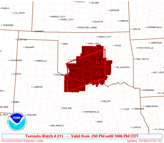
Tornado Watch Number 211
NWS Storm Prediction Center Norman OK
230 PM CDT Wed May 22 2019
The NWS Storm Prediction Center has issued a
* Tornado Watch for portions of
Southwest and Central Oklahoma
Western North Texas
* Effective this Wednesday afternoon and evening from 230 PM
until 1000 PM CDT.
...THIS IS A PARTICULARLY DANGEROUS SITUATION...
* Primary threats include...
Several tornadoes and a few intense tornadoes likely
Scattered large hail likely with isolated very large hail events
to 3 inches in diameter possible
Scattered damaging wind gusts to 70 mph possible
SUMMARY...Isolated intense thunderstorms are expected to affect the
watch area this afternoon and early evening. Any storm that
persists will pose a risk of strong tornadoes, very large hail, and
damaging winds.
The tornado watch area is approximately along and 60 statute miles
north and south of a line from 25 miles south of Altus OK to 45
miles south southeast of Chandler OK. For a complete depiction of
the watch see the associated watch outline update (WOUS64 KWNS
WOU1).
PRECAUTIONARY/PREPAREDNESS ACTIONS...
REMEMBER...A Tornado Watch means conditions are favorable for
tornadoes and severe thunderstorms in and close to the watch
area. Persons in these areas should be on the lookout for
threatening weather conditions and listen for later statements
and possible warnings.
&&
AVIATION...Tornadoes and a few severe thunderstorms with hail
surface and aloft to 3 inches. Extreme turbulence and surface wind
gusts to 60 knots. A few cumulonimbi with maximum tops to 500. Mean
storm motion vector 24030.
...Hart

   SEL1

   URGENT - IMMEDIATE BROADCAST REQUESTED
   Tornado Watch Number 211
   NWS Storm Prediction Center Norman OK
   230 PM CDT Wed May 22 2019

   The NWS Storm Prediction Center has issued a

   * Tornado Watch for portions of
     Southwest and Central Oklahoma
     Western North Texas

   * Effective this Wednesday afternoon and evening from 230 PM
     until 1000 PM CDT.

   ...THIS IS A PARTICULARLY DANGEROUS SITUATION...

   * Primary threats include...
     Several tornadoes and a few intense tornadoes likely
     Scattered large hail likely with isolated very large hail events
       to 3 inches in diameter possible
     Scattered damaging wind gusts to 70 mph possible

   SUMMARY...Isolated intense thunderstorms are expected to affect the
   watch area this afternoon and early evening.  Any storm that
   persists will pose a risk of strong tornadoes, very large hail, and
   damaging winds.

   The tornado watch area is approximately along and 60 statute miles
   north and south of a line from 25 miles south of Altus OK to 45
   miles south southeast of Chandler OK. For a complete depiction of
   the watch see the associated watch outline update (WOUS64 KWNS
   WOU1).

   PRECAUTIONARY/PREPAREDNESS ACTIONS...

   REMEMBER...A Tornado Watch means conditions are favorable for
   tornadoes and severe thunderstorms in and close to the watch
   area. Persons in these areas should be on the lookout for
   threatening weather conditions and listen for later statements
   and possible warnings.

   &&

   AVIATION...Tornadoes and a few severe thunderstorms with hail
   surface and aloft to 3 inches. Extreme turbulence and surface wind
   gusts to 60 knots. A few cumulonimbi with maximum tops to 500. Mean
   storm motion vector 24030.

   ...Hart
 Note:
The Aviation Watch (SAW) product is an approximation to the watch area.
The actual watch is depicted by the shaded areas.
Note:
The Aviation Watch (SAW) product is an approximation to the watch area.
The actual watch is depicted by the shaded areas.
   SAW1
   WW 211 TORNADO OK TX 221930Z - 230300Z
   AXIS..60 STATUTE MILES NORTH AND SOUTH OF LINE..
   25S LTS/ALTUS OK/ - 45SSE CQB/CHANDLER OK/
   ..AVIATION COORDS.. 50NM N/S /38WNW SPS - 40WNW MLC/
   HAIL SURFACE AND ALOFT..3 INCHES. WIND GUSTS..60 KNOTS.
   MAX TOPS TO 500. MEAN STORM MOTION VECTOR 24030.

   LAT...LON 35159926 35999651 34259651 33419926

   THIS IS AN APPROXIMATION TO THE WATCH AREA.  FOR A
   COMPLETE DEPICTION OF THE WATCH SEE WOUS64 KWNS
   FOR WOU1.
Watch 211 Status Report Messages:
STATUS REPORT #3 ON WW 211

VALID 230040Z - 230140Z

THE SEVERE WEATHER THREAT CONTINUES ACROSS THE ENTIRE WATCH AREA.

..KERR..05/23/19

ATTN...WFO...OUN...

&&

STATUS REPORT FOR WT 211

SEVERE WEATHER THREAT CONTINUES FOR THE FOLLOWING AREAS

OKC015-017-019-027-029-031-033-049-051-063-067-069-073-075-081-
083-085-087-095-099-109-119-123-125-133-137-141-230140-

OK
.    OKLAHOMA COUNTIES INCLUDED ARE

CADDO		     CANADIAN		 CARTER
CLEVELAND	     COAL		 COMANCHE
COTTON		     GARVIN		 GRADY
HUGHES		     JEFFERSON		 JOHNSTON
KINGFISHER	     KIOWA		 LINCOLN
LOGAN		     LOVE		 MCCLAIN
MARSHALL	     MURRAY		 OKLAHOMA
PAYNE		     PONTOTOC		 POTTAWATOMIE
SEMINOLE	     STEPHENS		 TILLMAN
$$


TXC009-023-077-485-487-230140-

TX
.    TEXAS COUNTIES INCLUDED ARE

ARCHER		     BAYLOR		 CLAY
WICHITA 	     WILBARGER
$$


THE WATCH STATUS MESSAGE IS FOR GUIDANCE PURPOSES ONLY.  PLEASE
REFER TO WATCH COUNTY NOTIFICATION STATEMENTS FOR OFFICIAL
INFORMATION ON COUNTIES...INDEPENDENT CITIES AND MARINE ZONES
CLEARED FROM SEVERE THUNDERSTORM AND TORNADO WATCHES.
$$

STATUS REPORT #2 ON WW 211

VALID 222325Z - 230040Z

THE SEVERE WEATHER THREAT CONTINUES ACROSS THE ENTIRE WATCH AREA.

..KERR..05/22/19

ATTN...WFO...OUN...

&&

STATUS REPORT FOR WT 211

SEVERE WEATHER THREAT CONTINUES FOR THE FOLLOWING AREAS

OKC015-017-019-027-029-031-033-049-051-063-067-069-073-075-081-
083-085-087-095-099-109-119-123-125-133-137-141-230040-

OK
.    OKLAHOMA COUNTIES INCLUDED ARE

CADDO		     CANADIAN		 CARTER
CLEVELAND	     COAL		 COMANCHE
COTTON		     GARVIN		 GRADY
HUGHES		     JEFFERSON		 JOHNSTON
KINGFISHER	     KIOWA		 LINCOLN
LOGAN		     LOVE		 MCCLAIN
MARSHALL	     MURRAY		 OKLAHOMA
PAYNE		     PONTOTOC		 POTTAWATOMIE
SEMINOLE	     STEPHENS		 TILLMAN
$$


TXC009-023-077-485-487-230040-

TX
.    TEXAS COUNTIES INCLUDED ARE

ARCHER		     BAYLOR		 CLAY
WICHITA 	     WILBARGER
$$


THE WATCH STATUS MESSAGE IS FOR GUIDANCE PURPOSES ONLY.  PLEASE
REFER TO WATCH COUNTY NOTIFICATION STATEMENTS FOR OFFICIAL
INFORMATION ON COUNTIES...INDEPENDENT CITIES AND MARINE ZONES
CLEARED FROM SEVERE THUNDERSTORM AND TORNADO WATCHES.
$$

STATUS REPORT #1 ON WW 211

VALID 222130Z - 222240Z

THE SEVERE WEATHER THREAT CONTINUES ACROSS THE ENTIRE WATCH AREA.

..KERR..05/22/19

ATTN...WFO...OUN...

&&

STATUS REPORT FOR WT 211

SEVERE WEATHER THREAT CONTINUES FOR THE FOLLOWING AREAS

OKC015-017-019-027-029-031-033-049-051-063-067-069-073-075-081-
083-085-087-095-099-109-119-123-125-133-137-141-222240-

OK
.    OKLAHOMA COUNTIES INCLUDED ARE

CADDO		     CANADIAN		 CARTER
CLEVELAND	     COAL		 COMANCHE
COTTON		     GARVIN		 GRADY
HUGHES		     JEFFERSON		 JOHNSTON
KINGFISHER	     KIOWA		 LINCOLN
LOGAN		     LOVE		 MCCLAIN
MARSHALL	     MURRAY		 OKLAHOMA
PAYNE		     PONTOTOC		 POTTAWATOMIE
SEMINOLE	     STEPHENS		 TILLMAN
$$


TXC009-023-077-485-487-222240-

TX
.    TEXAS COUNTIES INCLUDED ARE

ARCHER		     BAYLOR		 CLAY
WICHITA 	     WILBARGER
$$


THE WATCH STATUS MESSAGE IS FOR GUIDANCE PURPOSES ONLY.  PLEASE
REFER TO WATCH COUNTY NOTIFICATION STATEMENTS FOR OFFICIAL
INFORMATION ON COUNTIES...INDEPENDENT CITIES AND MARINE ZONES
CLEARED FROM SEVERE THUNDERSTORM AND TORNADO WATCHES.
$$
Note:
Click for Complete Product Text.
Tornadoes
Probability of 2 or more tornadoes
|
High (80%)
|
Probability of 1 or more strong (EF2-EF5) tornadoes
|
High (80%)
|
Wind
Probability of 10 or more severe wind events
|
Mod (40%)
|
Probability of 1 or more wind events > 65 knots
|
Low (20%)
|
Hail
Probability of 10 or more severe hail events
|
Mod (60%)
|
Probability of 1 or more hailstones > 2 inches
|
Mod (50%)
|
Combined Severe Hail/Wind
Probability of 6 or more combined severe hail/wind events
|
High (>95%)
|
For each watch, probabilities for particular events inside the watch
(listed above in each table) are determined by the issuing forecaster.
The "Low" category contains probability values ranging from less than 2%
to 20% (EF2-EF5 tornadoes), less than 5% to 20% (all other probabilities),
"Moderate" from 30% to 60%, and "High" from 70% to greater than 95%.
High values are bolded and lighter in color to provide awareness of
an increased threat for a particular event.


 @NWSSPC