 Note:
The expiration time in the watch graphic is amended if the watch is
replaced, cancelled or extended.
Note:
Note:
The expiration time in the watch graphic is amended if the watch is
replaced, cancelled or extended.
Note: Click for
Watch Status Reports.
SEL8
URGENT - IMMEDIATE BROADCAST REQUESTED
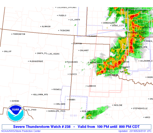
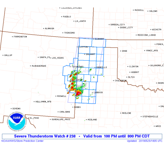
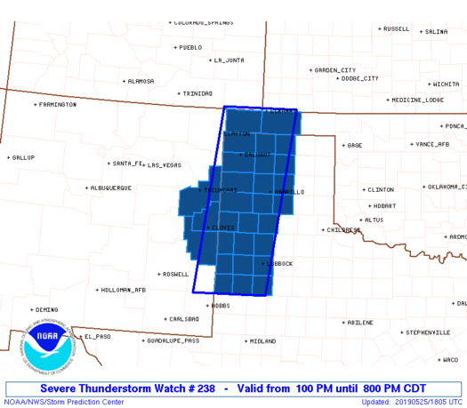
Severe Thunderstorm Watch Number 238
NWS Storm Prediction Center Norman OK
100 PM CDT Sat May 25 2019
The NWS Storm Prediction Center has issued a
* Severe Thunderstorm Watch for portions of
Eastern New Mexico
Oklahoma Panhandle
West Texas including the Panhandle
* Effective this Saturday afternoon and evening from 100 PM until
800 PM CDT.
* Primary threats include...
Widespread large hail and isolated very large hail events to 3
inches in diameter likely
Scattered damaging wind gusts to 70 mph likely
A tornado or two possible
SUMMARY...Thunderstorms will continue to increase in coverage this
afternoon over parts of eastern New Mexico and west Texas, with
large hail expected in the strongest cells. The risk of a tornado
or two will also increase later this afternoon.
The severe thunderstorm watch area is approximately along and 55
statute miles east and west of a line from 10 miles west northwest
of Elkhart KS to 70 miles southwest of Lubbock TX. For a complete
depiction of the watch see the associated watch outline update
(WOUS64 KWNS WOU8).
PRECAUTIONARY/PREPAREDNESS ACTIONS...
REMEMBER...A Severe Thunderstorm Watch means conditions are
favorable for severe thunderstorms in and close to the watch area.
Persons in these areas should be on the lookout for threatening
weather conditions and listen for later statements and possible
warnings. Severe thunderstorms can and occasionally do produce
tornadoes.
&&
AVIATION...A few severe thunderstorms with hail surface and aloft to
3 inches. Extreme turbulence and surface wind gusts to 60 knots. A
few cumulonimbi with maximum tops to 500. Mean storm motion vector
24030.
...Hart
   SEL8

   URGENT - IMMEDIATE BROADCAST REQUESTED
   Severe Thunderstorm Watch Number 238
   NWS Storm Prediction Center Norman OK
   100 PM CDT Sat May 25 2019

   The NWS Storm Prediction Center has issued a

   * Severe Thunderstorm Watch for portions of
     Eastern New Mexico
     Oklahoma Panhandle
     West Texas including the Panhandle

   * Effective this Saturday afternoon and evening from 100 PM until
     800 PM CDT.

   * Primary threats include...
     Widespread large hail and isolated very large hail events to 3
       inches in diameter likely
     Scattered damaging wind gusts to 70 mph likely
     A tornado or two possible

   SUMMARY...Thunderstorms will continue to increase in coverage this
   afternoon over parts of eastern New Mexico and west Texas, with
   large hail expected in the strongest cells.  The risk of a tornado
   or two will also increase later this afternoon.

   The severe thunderstorm watch area is approximately along and 55
   statute miles east and west of a line from 10 miles west northwest
   of Elkhart KS to 70 miles southwest of Lubbock TX. For a complete
   depiction of the watch see the associated watch outline update
   (WOUS64 KWNS WOU8).

   PRECAUTIONARY/PREPAREDNESS ACTIONS...

   REMEMBER...A Severe Thunderstorm Watch means conditions are
   favorable for severe thunderstorms in and close to the watch area.
   Persons in these areas should be on the lookout for threatening
   weather conditions and listen for later statements and possible
   warnings. Severe thunderstorms can and occasionally do produce
   tornadoes.

   &&

   AVIATION...A few severe thunderstorms with hail surface and aloft to
   3 inches. Extreme turbulence and surface wind gusts to 60 knots. A
   few cumulonimbi with maximum tops to 500. Mean storm motion vector
   24030.

   ...Hart
 Note:
The Aviation Watch (SAW) product is an approximation to the watch area.
The actual watch is depicted by the shaded areas.
Note:
The Aviation Watch (SAW) product is an approximation to the watch area.
The actual watch is depicted by the shaded areas.
   SAW8
   WW 238 SEVERE TSTM NM OK TX 251800Z - 260100Z
   AXIS..55 STATUTE MILES EAST AND WEST OF LINE..
   10WNW EHA/ELKHART KS/ - 70SW LBB/LUBBOCK TX/
   ..AVIATION COORDS.. 50NM E/W /53W LBL - 59SW LBB/
   HAIL SURFACE AND ALOFT..3 INCHES. WIND GUSTS..60 KNOTS.
   MAX TOPS TO 500. MEAN STORM MOTION VECTOR 24030.

   LAT...LON 37040106 32950173 32950362 37040305

   THIS IS AN APPROXIMATION TO THE WATCH AREA.  FOR A
   COMPLETE DEPICTION OF THE WATCH SEE WOUS64 KWNS
   FOR WOU8.
Watch 238 Status Report Messages:
STATUS REPORT #2 ON WW 238
VALID 252045Z - 252140Z
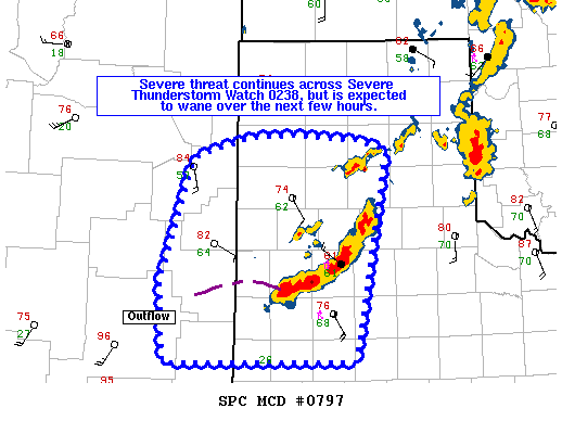
THE SEVERE WEATHER THREAT CONTINUES ACROSS THE ENTIRE WATCH AREA.
FOR ADDITIONAL INFORMATION SEE MESOSCALE DISCUSSION 792
..NAUSLAR..05/25/19
ATTN...WFO...ABQ...AMA...LUB...
&&
STATUS REPORT FOR WS 238
SEVERE WEATHER THREAT CONTINUES FOR THE FOLLOWING AREAS
NMC009-037-041-252140-
NM
. NEW MEXICO COUNTIES INCLUDED ARE
CURRY QUAY ROOSEVELT
$$
OKC025-139-252140-
OK
. OKLAHOMA COUNTIES INCLUDED ARE
CIMARRON TEXAS
$$
TXC011-017-065-069-079-111-117-189-195-205-219-233-279-303-305-
341-359-369-375-381-421-437-445-501-252140-
TX
. TEXAS COUNTIES INCLUDED ARE
ARMSTRONG BAILEY CARSON
CASTRO COCHRAN DALLAM
DEAF SMITH HALE HANSFORD
HARTLEY HOCKLEY HUTCHINSON
LAMB LUBBOCK LYNN
MOORE OLDHAM PARMER
POTTER RANDALL SHERMAN
SWISHER TERRY YOAKUM
$$
THE WATCH STATUS MESSAGE IS FOR GUIDANCE PURPOSES ONLY. PLEASE
REFER TO WATCH COUNTY NOTIFICATION STATEMENTS FOR OFFICIAL
INFORMATION ON COUNTIES...INDEPENDENT CITIES AND MARINE ZONES
CLEARED FROM SEVERE THUNDERSTORM AND TORNADO WATCHES.
$$
STATUS REPORT #1 ON WW 238
VALID 251950Z - 252040Z
THE SEVERE WEATHER THREAT CONTINUES ACROSS THE ENTIRE WATCH AREA.
..NAUSLAR..05/25/19
ATTN...WFO...ABQ...AMA...LUB...
&&
STATUS REPORT FOR WS 238
SEVERE WEATHER THREAT CONTINUES FOR THE FOLLOWING AREAS
NMC009-037-041-252040-
NM
. NEW MEXICO COUNTIES INCLUDED ARE
CURRY QUAY ROOSEVELT
$$
OKC025-139-252040-
OK
. OKLAHOMA COUNTIES INCLUDED ARE
CIMARRON TEXAS
$$
TXC011-017-065-069-079-111-117-189-195-205-219-233-279-303-305-
341-359-369-375-381-421-437-445-501-252040-
TX
. TEXAS COUNTIES INCLUDED ARE
ARMSTRONG BAILEY CARSON
CASTRO COCHRAN DALLAM
DEAF SMITH HALE HANSFORD
HARTLEY HOCKLEY HUTCHINSON
LAMB LUBBOCK LYNN
MOORE OLDHAM PARMER
POTTER RANDALL SHERMAN
SWISHER TERRY YOAKUM
$$
THE WATCH STATUS MESSAGE IS FOR GUIDANCE PURPOSES ONLY. PLEASE
REFER TO WATCH COUNTY NOTIFICATION STATEMENTS FOR OFFICIAL
INFORMATION ON COUNTIES...INDEPENDENT CITIES AND MARINE ZONES
CLEARED FROM SEVERE THUNDERSTORM AND TORNADO WATCHES.
$$
Note:
Click for Complete Product Text.
Tornadoes
Probability of 2 or more tornadoes
|
Low (20%)
|
Probability of 1 or more strong (EF2-EF5) tornadoes
|
Low (10%)
|
Wind
Probability of 10 or more severe wind events
|
Mod (60%)
|
Probability of 1 or more wind events > 65 knots
|
Low (20%)
|
Hail
Probability of 10 or more severe hail events
|
High (80%)
|
Probability of 1 or more hailstones > 2 inches
|
Mod (60%)
|
Combined Severe Hail/Wind
Probability of 6 or more combined severe hail/wind events
|
High (>95%)
|
For each watch, probabilities for particular events inside the watch
(listed above in each table) are determined by the issuing forecaster.
The "Low" category contains probability values ranging from less than 2%
to 20% (EF2-EF5 tornadoes), less than 5% to 20% (all other probabilities),
"Moderate" from 30% to 60%, and "High" from 70% to greater than 95%.
High values are bolded and lighter in color to provide awareness of
an increased threat for a particular event.


 @NWSSPC