Note:
The expiration time in the watch graphic is amended if the watch is
replaced, cancelled or extended.
Note:
Note:
The expiration time in the watch graphic is amended if the watch is
replaced, cancelled or extended.
Note: Click for
Watch Status Reports.
SEL2
URGENT - IMMEDIATE BROADCAST REQUESTED
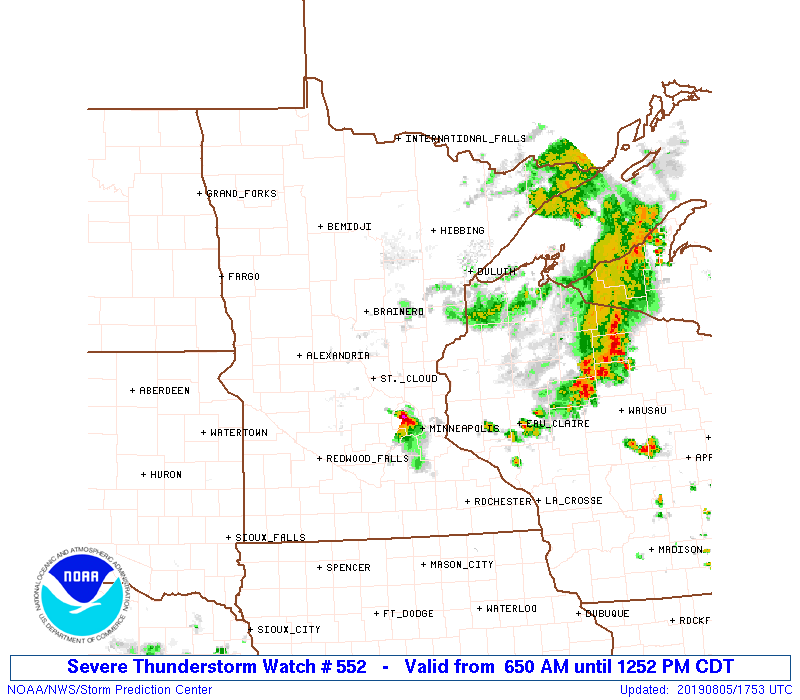
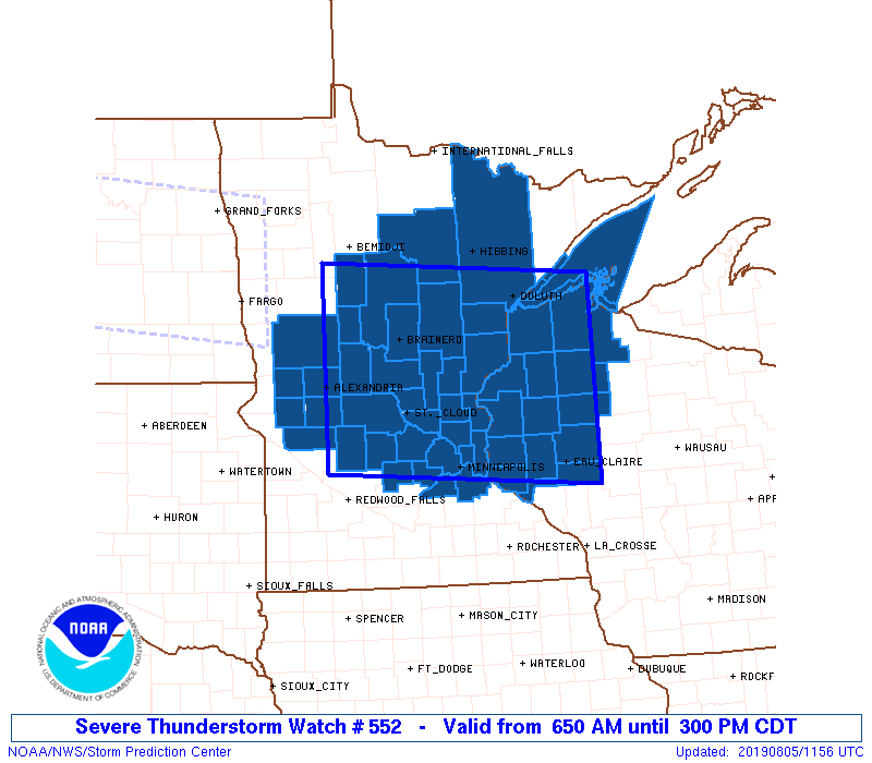
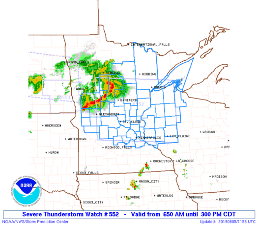
Severe Thunderstorm Watch Number 552
NWS Storm Prediction Center Norman OK
650 AM CDT Mon Aug 5 2019
The NWS Storm Prediction Center has issued a
* Severe Thunderstorm Watch for portions of
Central and northern Minnesota
Northwestern Wisconsin
Lake Superior
* Effective this Monday morning and afternoon from 650 AM until
300 PM CDT.
* Primary threats include...
Scattered damaging winds likely with isolated significant gusts
to 75 mph possible
Isolated large hail events to 1.5 inches in diameter possible
SUMMARY...A bowing cluster of thunderstorms, initially posing a
severe-wind threat across northern Minnesota, should move eastward
to southeastward across the watch area, with additional development
possible along its trailing cold pool/outflow boundary. The main
concern will remain damaging gusts, and isolated large hail also is
possible.
The severe thunderstorm watch area is approximately along and 85
statute miles north and south of a line from 15 miles north of
Alexandria MN to 50 miles south of Kennedy WI. For a complete
depiction of the watch see the associated watch outline update
(WOUS64 KWNS WOU2).
PRECAUTIONARY/PREPAREDNESS ACTIONS...
REMEMBER...A Severe Thunderstorm Watch means conditions are
favorable for severe thunderstorms in and close to the watch area.
Persons in these areas should be on the lookout for threatening
weather conditions and listen for later statements and possible
warnings. Severe thunderstorms can and occasionally do produce
tornadoes.
&&
OTHER WATCH INFORMATION...CONTINUE...WW 551...
AVIATION...A few severe thunderstorms with hail surface and aloft to
1.5 inches. Extreme turbulence and surface wind gusts to 65 knots. A
few cumulonimbi with maximum tops to 550. Mean storm motion vector
32035.
...Edwards
   SEL2

   URGENT - IMMEDIATE BROADCAST REQUESTED
   Severe Thunderstorm Watch Number 552
   NWS Storm Prediction Center Norman OK
   650 AM CDT Mon Aug 5 2019

   The NWS Storm Prediction Center has issued a

   * Severe Thunderstorm Watch for portions of
     Central and northern Minnesota
     Northwestern Wisconsin
     Lake Superior

   * Effective this Monday morning and afternoon from 650 AM until
     300 PM CDT.

   * Primary threats include...
     Scattered damaging winds likely with isolated significant gusts
       to 75 mph possible
     Isolated large hail events to 1.5 inches in diameter possible

   SUMMARY...A bowing cluster of thunderstorms, initially posing a
   severe-wind threat across northern Minnesota, should move eastward
   to southeastward across the watch area, with additional development
   possible along its trailing cold pool/outflow boundary.  The main
   concern will remain damaging gusts, and isolated large hail also is
   possible.

   The severe thunderstorm watch area is approximately along and 85
   statute miles north and south of a line from 15 miles north of
   Alexandria MN to 50 miles south of Kennedy WI. For a complete
   depiction of the watch see the associated watch outline update
   (WOUS64 KWNS WOU2).

   PRECAUTIONARY/PREPAREDNESS ACTIONS...

   REMEMBER...A Severe Thunderstorm Watch means conditions are
   favorable for severe thunderstorms in and close to the watch area.
   Persons in these areas should be on the lookout for threatening
   weather conditions and listen for later statements and possible
   warnings. Severe thunderstorms can and occasionally do produce
   tornadoes.

   &&

   OTHER WATCH INFORMATION...CONTINUE...WW 551...

   AVIATION...A few severe thunderstorms with hail surface and aloft to
   1.5 inches. Extreme turbulence and surface wind gusts to 65 knots. A
   few cumulonimbi with maximum tops to 550. Mean storm motion vector
   32035.

   ...Edwards
 Note:
The Aviation Watch (SAW) product is an approximation to the watch area.
The actual watch is depicted by the shaded areas.
Note:
The Aviation Watch (SAW) product is an approximation to the watch area.
The actual watch is depicted by the shaded areas.
   SAW2
   WW 552 SEVERE TSTM MN WI LS 051150Z - 052000Z
   AXIS..85 STATUTE MILES NORTH AND SOUTH OF LINE..
   15N AXN/ALEXANDRIA MN/ - 50S ASX/KENNEDY WI/
   ..AVIATION COORDS.. 75NM N/S /59WSW BRD - 60NNE EAU/
   HAIL SURFACE AND ALOFT..1.5 INCHES. WIND GUSTS..65 KNOTS.
   MAX TOPS TO 550. MEAN STORM MOTION VECTOR 32035.

   LAT...LON 47319540 47049091 44599091 44869540

   THIS IS AN APPROXIMATION TO THE WATCH AREA.  FOR A
   COMPLETE DEPICTION OF THE WATCH SEE WOUS64 KWNS
   FOR WOU2.
Watch 552 Status Report Messages:
STATUS REPORT #4 ON WW 552

VALID 051640Z - 051740Z

SEVERE WEATHER THREAT CONTINUES RIGHT OF A LINE FROM 15 SSE MSP
TO 50 NNE MSP TO 45 S ASX TO 30 S ASX.

..GOSS..08/05/19

ATTN...WFO...DLH...MPX...FGF...

&&

STATUS REPORT FOR WS 552

SEVERE WEATHER THREAT CONTINUES FOR THE FOLLOWING AREAS

WIC003-005-017-033-035-091-093-095-107-109-113-051740-

WI
.    WISCONSIN COUNTIES INCLUDED ARE

ASHLAND 	     BARRON		 CHIPPEWA
DUNN		     EAU CLAIRE 	 PEPIN
PIERCE		     POLK		 RUSK
ST. CROIX	     SAWYER
$$


LSZ142-143-148-051740-

CW

.    ADJACENT COASTAL WATERS INCLUDED ARE

TACONITE HARBOR TO SILVER BAY HARBOR MN

SILVER BAY HARBOR TO TWO HARBORS MN

OAK POINT TO SAXON HARBOR WI

$$
THE WATCH STATUS MESSAGE IS FOR GUIDANCE PURPOSES ONLY.  PLEASE
REFER TO WATCH COUNTY NOTIFICATION STATEMENTS FOR OFFICIAL
INFORMATION ON COUNTIES...INDEPENDENT CITIES AND MARINE ZONES
CLEARED FROM SEVERE THUNDERSTORM AND TORNADO WATCHES.
$$

STATUS REPORT #3 ON WW 552

VALID 051550Z - 051640Z

SEVERE WEATHER THREAT CONTINUES RIGHT OF A LINE FROM 15 SSE MSP
TO 50 NNE MSP TO 40 WSW ASX TO 10 SE BFW.

..GOSS..08/05/19

ATTN...WFO...DLH...MPX...FGF...

&&

STATUS REPORT FOR WS 552

SEVERE WEATHER THREAT CONTINUES FOR THE FOLLOWING AREAS

WIC003-005-007-013-017-031-033-035-091-093-095-107-109-113-129-
051640-

WI
.    WISCONSIN COUNTIES INCLUDED ARE

ASHLAND 	     BARRON		 BAYFIELD
BURNETT 	     CHIPPEWA		 DOUGLAS
DUNN		     EAU CLAIRE 	 PEPIN
PIERCE		     POLK		 RUSK
ST. CROIX	     SAWYER		 WASHBURN
$$


LSZ121-142-143-146-147-148-051640-

CW

.    ADJACENT COASTAL WATERS INCLUDED ARE

CHEQUAMEGON BAY-BAYFIELD TO OAK POINT WI

TACONITE HARBOR TO SILVER BAY HARBOR MN

SILVER BAY HARBOR TO TWO HARBORS MN

PORT WING TO SAND ISLAND WI

SAND ISLAND TO BAYFIELD WI

OAK POINT TO SAXON HARBOR WI

$$
THE WATCH STATUS MESSAGE IS FOR GUIDANCE PURPOSES ONLY.  PLEASE
REFER TO WATCH COUNTY NOTIFICATION STATEMENTS FOR OFFICIAL
INFORMATION ON COUNTIES...INDEPENDENT CITIES AND MARINE ZONES
CLEARED FROM SEVERE THUNDERSTORM AND TORNADO WATCHES.
$$

STATUS REPORT #2 ON WW 552

VALID 051435Z - 051540Z

SEVERE WEATHER THREAT CONTINUES RIGHT OF A LINE FROM 40 S AXN TO
45 NE STC TO 10 W DLH TO 25 NNW DLH.

..GOSS..08/05/19

ATTN...WFO...DLH...MPX...FGF...

&&

STATUS REPORT FOR WS 552

SEVERE WEATHER THREAT CONTINUES FOR THE FOLLOWING AREAS

MNC003-017-019-025-037-053-059-065-085-095-115-123-137-139-141-
163-171-051540-

MN
.    MINNESOTA COUNTIES INCLUDED ARE

ANOKA		     CARLTON		 CARVER
CHISAGO 	     DAKOTA		 HENNEPIN
ISANTI		     KANABEC		 MCLEOD
MILLE LACS	     PINE		 RAMSEY
ST. LOUIS	     SCOTT		 SHERBURNE
WASHINGTON	     WRIGHT
$$


WIC003-005-007-013-017-031-033-035-091-093-095-107-109-113-129-
051540-

WI
.    WISCONSIN COUNTIES INCLUDED ARE

ASHLAND 	     BARRON		 BAYFIELD
BURNETT 	     CHIPPEWA		 DOUGLAS
DUNN		     EAU CLAIRE 	 PEPIN
PIERCE		     POLK		 RUSK
ST. CROIX	     SAWYER		 WASHBURN
$$


LSZ121-142-143-144-145-146-147-148-162-051540-

CW

.    ADJACENT COASTAL WATERS INCLUDED ARE

CHEQUAMEGON BAY-BAYFIELD TO OAK POINT WI

TACONITE HARBOR TO SILVER BAY HARBOR MN

SILVER BAY HARBOR TO TWO HARBORS MN

TWO HARBORS TO DULUTH MN

DULUTH MN TO PORT WING WI

PORT WING TO SAND ISLAND WI

SAND ISLAND TO BAYFIELD WI

OAK POINT TO SAXON HARBOR WI

LAKE SUPERIOR WEST OF A LINE FROM SAXON HARBOR WI TO GRAND
PORTAGE MN BEYOND 5NM

$$
THE WATCH STATUS MESSAGE IS FOR GUIDANCE PURPOSES ONLY.  PLEASE
REFER TO WATCH COUNTY NOTIFICATION STATEMENTS FOR OFFICIAL
INFORMATION ON COUNTIES...INDEPENDENT CITIES AND MARINE ZONES
CLEARED FROM SEVERE THUNDERSTORM AND TORNADO WATCHES.
$$

STATUS REPORT #1 ON WW 552

VALID 051350Z - 051440Z

SEVERE WEATHER THREAT CONTINUES RIGHT OF A LINE FROM 10 SW AXN TO
15 E BRD TO 45 SSW HIB TO 15 SSW HIB.

..GOSS..08/05/19

ATTN...WFO...DLH...MPX...FGF...

&&

STATUS REPORT FOR WS 552

SEVERE WEATHER THREAT CONTINUES FOR THE FOLLOWING AREAS

MNC001-003-009-017-019-025-035-037-053-059-065-067-085-093-095-
097-115-121-123-137-139-141-145-149-151-163-171-051440-

MN
.    MINNESOTA COUNTIES INCLUDED ARE

AITKIN		     ANOKA		 BENTON
CARLTON 	     CARVER		 CHISAGO
CROW WING	     DAKOTA		 HENNEPIN
ISANTI		     KANABEC		 KANDIYOHI
MCLEOD		     MEEKER		 MILLE LACS
MORRISON	     PINE		 POPE
RAMSEY		     ST. LOUIS		 SCOTT
SHERBURNE	     STEARNS		 STEVENS
SWIFT		     WASHINGTON 	 WRIGHT
$$


WIC003-005-007-013-017-031-033-035-091-093-095-107-109-113-129-
051440-

WI
.    WISCONSIN COUNTIES INCLUDED ARE

ASHLAND 	     BARRON		 BAYFIELD
BURNETT 	     CHIPPEWA		 DOUGLAS
DUNN		     EAU CLAIRE 	 PEPIN
PIERCE		     POLK		 RUSK
ST. CROIX	     SAWYER		 WASHBURN
$$


LSZ121-142-143-144-145-146-147-148-162-051440-

CW

.    ADJACENT COASTAL WATERS INCLUDED ARE

CHEQUAMEGON BAY-BAYFIELD TO OAK POINT WI

TACONITE HARBOR TO SILVER BAY HARBOR MN

SILVER BAY HARBOR TO TWO HARBORS MN

TWO HARBORS TO DULUTH MN

DULUTH MN TO PORT WING WI

PORT WING TO SAND ISLAND WI

SAND ISLAND TO BAYFIELD WI

OAK POINT TO SAXON HARBOR WI

LAKE SUPERIOR WEST OF A LINE FROM SAXON HARBOR WI TO GRAND
PORTAGE MN BEYOND 5NM

$$
THE WATCH STATUS MESSAGE IS FOR GUIDANCE PURPOSES ONLY.  PLEASE
REFER TO WATCH COUNTY NOTIFICATION STATEMENTS FOR OFFICIAL
INFORMATION ON COUNTIES...INDEPENDENT CITIES AND MARINE ZONES
CLEARED FROM SEVERE THUNDERSTORM AND TORNADO WATCHES.
$$
Note:
Click for Complete Product Text.
Tornadoes
Probability of 2 or more tornadoes
|
Low (10%)
|
Probability of 1 or more strong (EF2-EF5) tornadoes
|
Low (<2%)
|
Wind
Probability of 10 or more severe wind events
|
Mod (60%)
|
Probability of 1 or more wind events > 65 knots
|
Mod (30%)
|
Hail
Probability of 10 or more severe hail events
|
Low (20%)
|
Probability of 1 or more hailstones > 2 inches
|
Low (10%)
|
Combined Severe Hail/Wind
Probability of 6 or more combined severe hail/wind events
|
High (80%)
|
For each watch, probabilities for particular events inside the watch
(listed above in each table) are determined by the issuing forecaster.
The "Low" category contains probability values ranging from less than 2%
to 20% (EF2-EF5 tornadoes), less than 5% to 20% (all other probabilities),
"Moderate" from 30% to 60%, and "High" from 70% to greater than 95%.
High values are bolded and lighter in color to provide awareness of
an increased threat for a particular event.


 @NWSSPC