 Note:
The expiration time in the watch graphic is amended if the watch is
replaced, cancelled or extended.
Note:
Note:
The expiration time in the watch graphic is amended if the watch is
replaced, cancelled or extended.
Note: Click for
Watch Status Reports.
SEL2
URGENT - IMMEDIATE BROADCAST REQUESTED
Severe Thunderstorm Watch Number 152
NWS Storm Prediction Center Norman OK
1235 PM CDT Thu May 6 2021
The NWS Storm Prediction Center has issued a
* Severe Thunderstorm Watch for portions of
Northeast Arkansas
Southern Illinois
Far southwest Indiana
Western Kentucky
Southeast Missouri
Western Tennessee
* Effective this Thursday afternoon and evening from 1235 PM
until 600 PM CDT.
* Primary threats include...
Scattered damaging winds and isolated significant gusts to 75
mph possible
Scattered large hail and isolated very large hail events to 2
inches in diameter possible
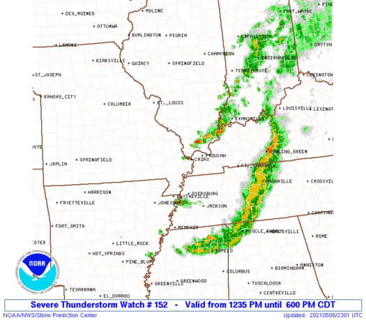
SUMMARY...Multiple lower-topped supercells should develop within a
cluster of thunderstorms spreading east-southeast across the
Mid-Mississippi into the Lower Ohio Valleys. Large hail and damaging
winds should be the primary hazards.
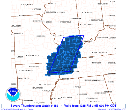
The severe thunderstorm watch area is approximately along and 60
statute miles east and west of a line from 40 miles east northeast
of Mount Vernon IL to 35 miles east southeast of Jonesboro AR. For a
complete depiction of the watch see the associated watch outline
update (WOUS64 KWNS WOU2).
PRECAUTIONARY/PREPAREDNESS ACTIONS...
REMEMBER...A Severe Thunderstorm Watch means conditions are
favorable for severe thunderstorms in and close to the watch area.
Persons in these areas should be on the lookout for threatening
weather conditions and listen for later statements and possible
warnings. Severe thunderstorms can and occasionally do produce
tornadoes.
&&
AVIATION...A few severe thunderstorms with hail surface and aloft to
2 inches. Extreme turbulence and surface wind gusts to 65 knots. A
few cumulonimbi with maximum tops to 400. Mean storm motion vector
29035.
...Grams
 Note:
The Aviation Watch (SAW) product is an approximation to the watch area.
The actual watch is depicted by the shaded areas.
Note:
The Aviation Watch (SAW) product is an approximation to the watch area.
The actual watch is depicted by the shaded areas.
   SAW2
   WW 152 SEVERE TSTM AR IL IN KY MO TN 061735Z - 062300Z
   AXIS..60 STATUTE MILES EAST AND WEST OF LINE..
   40ENE MVN/MOUNT VERNON IL/ - 35ESE JBR/JONESBORO AR/
   ..AVIATION COORDS.. 50NM E/W /42NNW PXV - 35N MEM/
   HAIL SURFACE AND ALOFT..2 INCHES. WIND GUSTS..65 KNOTS.
   MAX TOPS TO 400. MEAN STORM MOTION VECTOR 29035.

   LAT...LON 38538708 35638901 35639114 38538930

   THIS IS AN APPROXIMATION TO THE WATCH AREA.  FOR A
   COMPLETE DEPICTION OF THE WATCH SEE WOUS64 KWNS
   FOR WOU2.
Watch 152 Status Report Messages:
STATUS REPORT #1 ON WW 152

VALID 062020Z - 062140Z

THE SEVERE WEATHER THREAT CONTINUES ACROSS THE ENTIRE WATCH AREA.

FOR ADDITIONAL INFORMATION SEE MESOSCALE DISCUSSION 554

..MOSIER..05/06/21

ATTN...WFO...MEG...LZK...PAH...

&&

STATUS REPORT FOR WS 152

SEVERE WEATHER THREAT CONTINUES FOR THE FOLLOWING AREAS

ARC021-031-035-037-055-067-075-093-111-121-062140-

AR
.    ARKANSAS COUNTIES INCLUDED ARE

CLAY		     CRAIGHEAD		 CRITTENDEN
CROSS		     GREENE		 JACKSON
LAWRENCE	     MISSISSIPPI	 POINSETT
RANDOLPH
$$


ILC003-047-055-059-065-069-077-081-087-127-145-151-153-165-181-
185-191-193-199-062140-

IL
.    ILLINOIS COUNTIES INCLUDED ARE

ALEXANDER	     EDWARDS		 FRANKLIN
GALLATIN	     HAMILTON		 HARDIN
JACKSON 	     JEFFERSON		 JOHNSON
MASSAC		     PERRY		 POPE
PULASKI 	     SALINE		 UNION
WABASH		     WAYNE		 WHITE
WILLIAMSON
$$


INC051-129-163-062140-

IN
.    INDIANA COUNTIES INCLUDED ARE

GIBSON		     POSEY		 VANDERBURGH
$$


KYC007-033-035-039-055-075-083-101-105-139-143-145-157-221-225-
233-062140-

KY
.    KENTUCKY COUNTIES INCLUDED ARE

BALLARD 	     CALDWELL		 CALLOWAY
CARLISLE	     CRITTENDEN 	 FULTON
GRAVES		     HENDERSON		 HICKMAN
LIVINGSTON	     LYON		 MCCRACKEN
MARSHALL	     TRIGG		 UNION
WEBSTER
$$


MOC017-023-031-035-069-133-143-155-157-181-201-207-223-062140-

MO
.    MISSOURI COUNTIES INCLUDED ARE

BOLLINGER	     BUTLER		 CAPE GIRARDEAU
CARTER		     DUNKLIN		 MISSISSIPPI
NEW MADRID	     PEMISCOT		 PERRY
RIPLEY		     SCOTT		 STODDARD
WAYNE
$$


TNC017-033-045-047-053-069-075-079-095-097-113-131-157-167-183-
062140-

TN
.    TENNESSEE COUNTIES INCLUDED ARE

CARROLL 	     CROCKETT		 DYER
FAYETTE 	     GIBSON		 HARDEMAN
HAYWOOD 	     HENRY		 LAKE
LAUDERDALE	     MADISON		 OBION
SHELBY		     TIPTON		 WEAKLEY
$$


THE WATCH STATUS MESSAGE IS FOR GUIDANCE PURPOSES ONLY.  PLEASE
REFER TO WATCH COUNTY NOTIFICATION STATEMENTS FOR OFFICIAL
INFORMATION ON COUNTIES...INDEPENDENT CITIES AND MARINE ZONES
CLEARED FROM SEVERE THUNDERSTORM AND TORNADO WATCHES.
$$
Note:
Click for Complete Product Text.
Tornadoes
Probability of 2 or more tornadoes
|
Low (10%)
|
Probability of 1 or more strong (EF2-EF5) tornadoes
|
Low (5%)
|
Wind
Probability of 10 or more severe wind events
|
Mod (40%)
|
Probability of 1 or more wind events > 65 knots
|
Mod (30%)
|
Hail
Probability of 10 or more severe hail events
|
Mod (50%)
|
Probability of 1 or more hailstones > 2 inches
|
Mod (40%)
|
Combined Severe Hail/Wind
Probability of 6 or more combined severe hail/wind events
|
High (80%)
|
For each watch, probabilities for particular events inside the watch
(listed above in each table) are determined by the issuing forecaster.
The "Low" category contains probability values ranging from less than 2%
to 20% (EF2-EF5 tornadoes), less than 5% to 20% (all other probabilities),
"Moderate" from 30% to 60%, and "High" from 70% to greater than 95%.
High values are bolded and lighter in color to provide awareness of
an increased threat for a particular event.


 @NWSSPC


