 Note:
The expiration time in the watch graphic is amended if the watch is
replaced, cancelled or extended.
Note:
Note:
The expiration time in the watch graphic is amended if the watch is
replaced, cancelled or extended.
Note: Click for
Watch Status Reports.
SEL5
URGENT - IMMEDIATE BROADCAST REQUESTED
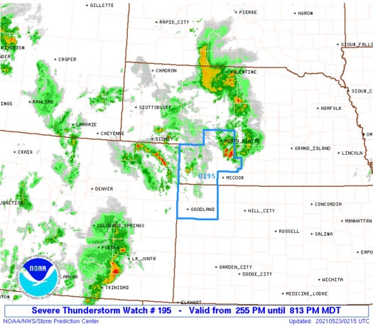
Severe Thunderstorm Watch Number 195
NWS Storm Prediction Center Norman OK
255 PM MDT Sat May 22 2021
The NWS Storm Prediction Center has issued a
* Severe Thunderstorm Watch for portions of
Northwest Kansas
Southwest Nebraska
* Effective this Saturday afternoon and evening from 255 PM until
1000 PM MDT.
* Primary threats include...
Scattered large hail and isolated very large hail events to 2
inches in diameter possible
Isolated damaging wind gusts to 70 mph possible
A tornado or two possible
SUMMARY...Strong to severe thunderstorms will continue to develop
generally northeastward across the region, especially in vicinity of
a front that extends from northeast Colorado into southwest Nebraska
including areas near/north of Ogallala. Large hail and damaging
winds are possible, and a tornado risk may also exist, especially
near the aforementioned boundary near Ogallala.
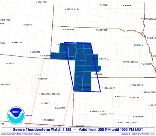
The severe thunderstorm watch area is approximately along and 55
statute miles east and west of a line from 90 miles northwest of
North Platte NE to 40 miles east southeast of Goodland KS. For a
complete depiction of the watch see the associated watch outline
update (WOUS64 KWNS WOU5).
PRECAUTIONARY/PREPAREDNESS ACTIONS...
REMEMBER...A Severe Thunderstorm Watch means conditions are
favorable for severe thunderstorms in and close to the watch area.
Persons in these areas should be on the lookout for threatening
weather conditions and listen for later statements and possible
warnings. Severe thunderstorms can and occasionally do produce
tornadoes.
&&
OTHER WATCH INFORMATION...CONTINUE...WW 193...WW 194...
AVIATION...A few severe thunderstorms with hail surface and aloft to
2 inches. Extreme turbulence and surface wind gusts to 60 knots. A
few cumulonimbi with maximum tops to 500. Mean storm motion vector
22025.
...Guyer
SEL5
URGENT - IMMEDIATE BROADCAST REQUESTED
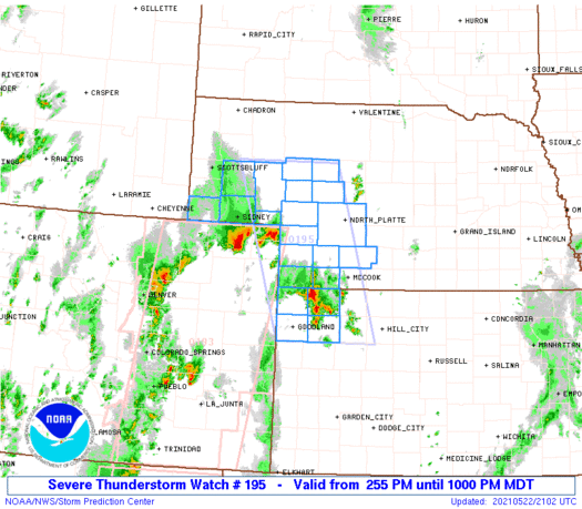
Severe Thunderstorm Watch Number 195
NWS Storm Prediction Center Norman OK
255 PM MDT Sat May 22 2021
The NWS Storm Prediction Center has issued a
* Severe Thunderstorm Watch for portions of
Northwest Kansas
Southwest Nebraska
* Effective this Saturday afternoon and evening from 255 PM until
1000 PM MDT.
* Primary threats include...
Scattered large hail and isolated very large hail events to 2
inches in diameter possible
Isolated damaging wind gusts to 70 mph possible
A tornado or two possible
SUMMARY...Strong to severe thunderstorms will continue to develop
generally northeastward across the region, especially in vicinity of
a front that extends from northeast Colorado into southwest Nebraska
including areas near/north of Ogallala. Large hail and damaging
winds are possible, and a tornado risk may also exist, especially
near the aforementioned boundary near Ogallala.
The severe thunderstorm watch area is approximately along and 55
statute miles east and west of a line from 90 miles northwest of
North Platte NE to 40 miles east southeast of Goodland KS. For a
complete depiction of the watch see the associated watch outline
update (WOUS64 KWNS WOU5).
PRECAUTIONARY/PREPAREDNESS ACTIONS...
REMEMBER...A Severe Thunderstorm Watch means conditions are
favorable for severe thunderstorms in and close to the watch area.
Persons in these areas should be on the lookout for threatening
weather conditions and listen for later statements and possible
warnings. Severe thunderstorms can and occasionally do produce
tornadoes.
&&
OTHER WATCH INFORMATION...CONTINUE...WW 193...WW 194...
AVIATION...A few severe thunderstorms with hail surface and aloft to
2 inches. Extreme turbulence and surface wind gusts to 60 knots. A
few cumulonimbi with maximum tops to 500. Mean storm motion vector
22025.
...Guyer
 Note:
The Aviation Watch (SAW) product is an approximation to the watch area.
The actual watch is depicted by the shaded areas.
Note:
The Aviation Watch (SAW) product is an approximation to the watch area.
The actual watch is depicted by the shaded areas.
   SAW5
   WW 195 SEVERE TSTM KS NE 222055Z - 230400Z
   AXIS..55 STATUTE MILES EAST AND WEST OF LINE..
   90NW LBF/NORTH PLATTE NE/ - 40ESE GLD/GOODLAND KS/
   ..AVIATION COORDS.. 50NM E/W /70E BFF - 35ESE GLD/
   HAIL SURFACE AND ALOFT..2 INCHES. WIND GUSTS..60 KNOTS.
   MAX TOPS TO 500. MEAN STORM MOTION VECTOR 22025.

   LAT...LON 42040085 39139998 39130204 42040299

   THIS IS AN APPROXIMATION TO THE WATCH AREA.  FOR A
   COMPLETE DEPICTION OF THE WATCH SEE WOUS64 KWNS
   FOR WOU5.
Watch 195 Status Report Messages:
STATUS REPORT #3 ON WW 195

VALID 230045Z - 230140Z

SEVERE WEATHER THREAT CONTINUES RIGHT OF A LINE FROM 35 SE SNY TO
30 NNE LBF.

..WENDT..05/23/21

ATTN...WFO...GLD...LBF...CYS...

&&

STATUS REPORT FOR WS 195

SEVERE WEATHER THREAT CONTINUES FOR THE FOLLOWING AREAS

KSC023-153-181-193-230140-

KS
.    KANSAS COUNTIES INCLUDED ARE

CHEYENNE	     RAWLINS		 SHERMAN
THOMAS
$$


NEC029-057-063-085-087-111-135-230140-

NE
.    NEBRASKA COUNTIES INCLUDED ARE

CHASE		     DUNDY		 FRONTIER
HAYES		     HITCHCOCK		 LINCOLN
PERKINS
$$


THE WATCH STATUS MESSAGE IS FOR GUIDANCE PURPOSES ONLY.  PLEASE
REFER TO WATCH COUNTY NOTIFICATION STATEMENTS FOR OFFICIAL
INFORMATION ON COUNTIES...INDEPENDENT CITIES AND MARINE ZONES
CLEARED FROM SEVERE THUNDERSTORM AND TORNADO WATCHES.
$$

STATUS REPORT #2 ON WW 195

VALID 222345Z - 230040Z

THE SEVERE WEATHER THREAT CONTINUES ACROSS THE ENTIRE WATCH AREA.

FOR ADDITIONAL INFORMATION SEE MESOSCALE DISCUSSION 706

..WENDT..05/22/21

ATTN...WFO...GLD...LBF...CYS...

&&

STATUS REPORT FOR WS 195

SEVERE WEATHER THREAT CONTINUES FOR THE FOLLOWING AREAS

KSC023-153-181-193-230040-

KS
.    KANSAS COUNTIES INCLUDED ARE

CHEYENNE	     RAWLINS		 SHERMAN
THOMAS
$$


NEC005-029-033-049-057-063-069-075-085-087-091-101-105-111-117-
123-135-230040-

NE
.    NEBRASKA COUNTIES INCLUDED ARE

ARTHUR		     CHASE		 CHEYENNE
DEUEL		     DUNDY		 FRONTIER
GARDEN		     GRANT		 HAYES
HITCHCOCK	     HOOKER		 KEITH
KIMBALL 	     LINCOLN		 MCPHERSON
MORRILL 	     PERKINS
$$


THE WATCH STATUS MESSAGE IS FOR GUIDANCE PURPOSES ONLY.  PLEASE
REFER TO WATCH COUNTY NOTIFICATION STATEMENTS FOR OFFICIAL
INFORMATION ON COUNTIES...INDEPENDENT CITIES AND MARINE ZONES
CLEARED FROM SEVERE THUNDERSTORM AND TORNADO WATCHES.
$$

STATUS REPORT #1 ON WW 195

VALID 222300Z - 230040Z

THE SEVERE WEATHER THREAT CONTINUES ACROSS THE ENTIRE WATCH AREA.

..WENDT..05/22/21

ATTN...WFO...GLD...LBF...CYS...

&&

STATUS REPORT FOR WS 195

SEVERE WEATHER THREAT CONTINUES FOR THE FOLLOWING AREAS

KSC023-153-181-193-230040-

KS
.    KANSAS COUNTIES INCLUDED ARE

CHEYENNE	     RAWLINS		 SHERMAN
THOMAS
$$


NEC005-029-033-049-057-063-069-075-085-087-091-101-105-111-117-
123-135-230040-

NE
.    NEBRASKA COUNTIES INCLUDED ARE

ARTHUR		     CHASE		 CHEYENNE
DEUEL		     DUNDY		 FRONTIER
GARDEN		     GRANT		 HAYES
HITCHCOCK	     HOOKER		 KEITH
KIMBALL 	     LINCOLN		 MCPHERSON
MORRILL 	     PERKINS
$$


THE WATCH STATUS MESSAGE IS FOR GUIDANCE PURPOSES ONLY.  PLEASE
REFER TO WATCH COUNTY NOTIFICATION STATEMENTS FOR OFFICIAL
INFORMATION ON COUNTIES...INDEPENDENT CITIES AND MARINE ZONES
CLEARED FROM SEVERE THUNDERSTORM AND TORNADO WATCHES.
$$
Note:
Click for Complete Product Text.
Tornadoes
Probability of 2 or more tornadoes
|
Low (20%)
|
Probability of 1 or more strong (EF2-EF5) tornadoes
|
Low (5%)
|
Wind
Probability of 10 or more severe wind events
|
Mod (30%)
|
Probability of 1 or more wind events > 65 knots
|
Low (10%)
|
Hail
Probability of 10 or more severe hail events
|
Mod (40%)
|
Probability of 1 or more hailstones > 2 inches
|
Mod (30%)
|
Combined Severe Hail/Wind
Probability of 6 or more combined severe hail/wind events
|
High (70%)
|
For each watch, probabilities for particular events inside the watch
(listed above in each table) are determined by the issuing forecaster.
The "Low" category contains probability values ranging from less than 2%
to 20% (EF2-EF5 tornadoes), less than 5% to 20% (all other probabilities),
"Moderate" from 30% to 60%, and "High" from 70% to greater than 95%.
High values are bolded and lighter in color to provide awareness of
an increased threat for a particular event.


 @NWSSPC


