 Note:
The expiration time in the watch graphic is amended if the watch is
replaced, cancelled or extended.
Note:
Note:
The expiration time in the watch graphic is amended if the watch is
replaced, cancelled or extended.
Note: Click for
Watch Status Reports.
SEL5
URGENT - IMMEDIATE BROADCAST REQUESTED
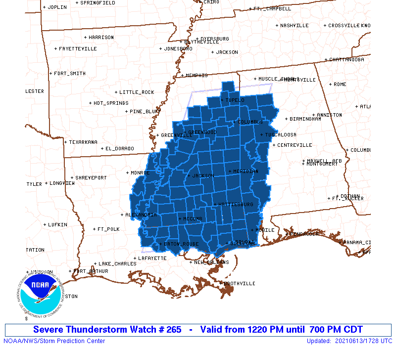
Severe Thunderstorm Watch Number 265
NWS Storm Prediction Center Norman OK
1220 PM CDT Sun Jun 13 2021
The NWS Storm Prediction Center has issued a
* Severe Thunderstorm Watch for portions of
Western Alabama
Eastern Louisiana
Mississippi
Coastal Waters
* Effective this Sunday afternoon and evening from 1220 PM until
700 PM CDT.
* Primary threats include...
Scattered damaging winds likely with isolated significant gusts
to 80 mph possible
Isolated large hail events to 1.5 inches in diameter possible
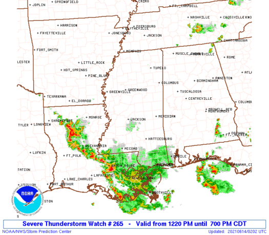
SUMMARY...Several loosely organized multicell clusters should spread
south-southwest across the region through early evening. Damaging
winds will be the primary hazard.
The severe thunderstorm watch area is approximately along and 75
statute miles east and west of a line from 30 miles northeast of
Tupelo MS to 40 miles west of Slidell LA. For a complete depiction
of the watch see the associated watch outline update (WOUS64 KWNS
WOU5).
PRECAUTIONARY/PREPAREDNESS ACTIONS...
REMEMBER...A Severe Thunderstorm Watch means conditions are
favorable for severe thunderstorms in and close to the watch area.
Persons in these areas should be on the lookout for threatening
weather conditions and listen for later statements and possible
warnings. Severe thunderstorms can and occasionally do produce
tornadoes.
&&
OTHER WATCH INFORMATION...CONTINUE...WW 264...
AVIATION...A few severe thunderstorms with hail surface and aloft to
1.5 inches. Extreme turbulence and surface wind gusts to 70 knots. A
few cumulonimbi with maximum tops to 600. Mean storm motion vector
01020.
...Grams
 Note:
The Aviation Watch (SAW) product is an approximation to the watch area.
The actual watch is depicted by the shaded areas.
Note:
The Aviation Watch (SAW) product is an approximation to the watch area.
The actual watch is depicted by the shaded areas.
SAW5
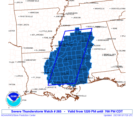
WW 265 SEVERE TSTM AL LA MS CW 131720Z - 140000Z
AXIS..75 STATUTE MILES EAST AND WEST OF LINE..
30NE TUP/TUPELO MS/ - 40W ASD/SLIDELL LA/
..AVIATION COORDS.. 65NM E/W /46W MSL - 39NW HRV/
HAIL SURFACE AND ALOFT..1.5 INCHES. WIND GUSTS..70 KNOTS.
MAX TOPS TO 600. MEAN STORM MOTION VECTOR 01020.
LAT...LON 34578708 30348923 30349175 34578972
THIS IS AN APPROXIMATION TO THE WATCH AREA. FOR A
COMPLETE DEPICTION OF THE WATCH SEE WOUS64 KWNS
FOR WOU5.
Watch 265 Status Report Messages:
STATUS REPORT #6 ON WW 265

VALID 132345Z - 140040Z

SEVERE WEATHER THREAT CONTINUES RIGHT OF A LINE FROM 20 S GLH TO
35 SSW GWO TO 50 SSE GWO TO 60 W MEI TO 35 NW PIB TO 10 E PIB TO
40 SW GZH.

..MOORE..06/13/21

ATTN...WFO...MOB...BMX...JAN...LIX...MEG...

&&

STATUS REPORT FOR WS 265

SEVERE WEATHER THREAT CONTINUES FOR THE FOLLOWING AREAS

ALC097-140040-

AL
.    ALABAMA COUNTIES INCLUDED ARE

MOBILE
$$


LAC025-029-033-035-037-041-063-065-077-091-103-105-107-117-121-
125-140040-

LA
.    LOUISIANA PARISHES INCLUDED ARE

CATAHOULA	     CONCORDIA		 EAST BATON ROUGE
EAST CARROLL	     EAST FELICIANA	 FRANKLIN
LIVINGSTON	     MADISON		 POINTE COUPEE
ST. HELENA	     ST. TAMMANY	 TANGIPAHOA
TENSAS		     WASHINGTON 	 WEST BATON ROUGE
WEST FELICIANA
$$


MSC001-005-021-029-031-035-037-039-041-045-047-049-055-059-063-
065-073-077-085-089-091-109-111-113-121-125-127-131-147-149-157-
163-140040-

MS
.    MISSISSIPPI COUNTIES INCLUDED ARE

ADAMS		     AMITE		 CLAIBORNE
COPIAH		     COVINGTON		 FORREST
FRANKLIN	     GEORGE		 GREENE
HANCOCK 	     HARRISON		 HINDS
ISSAQUENA	     JACKSON		 JEFFERSON
JEFFERSON DAVIS      LAMAR		 LAWRENCE
LINCOLN 	     MADISON		 MARION
PEARL RIVER	     PERRY		 PIKE
RANKIN		     SHARKEY		 SIMPSON
STONE		     WALTHALL		 WARREN
WILKINSON	     YAZOO
$$


GMZ532-632-140040-

CW

.    ADJACENT COASTAL WATERS INCLUDED ARE

MISSISSIPPI SOUND

MISSISSIPPI SOUND

$$
THE WATCH STATUS MESSAGE IS FOR GUIDANCE PURPOSES ONLY.  PLEASE
REFER TO WATCH COUNTY NOTIFICATION STATEMENTS FOR OFFICIAL
INFORMATION ON COUNTIES...INDEPENDENT CITIES AND MARINE ZONES
CLEARED FROM SEVERE THUNDERSTORM AND TORNADO WATCHES.
$$

STATUS REPORT #5 ON WW 265

VALID 132230Z - 132340Z

SEVERE WEATHER THREAT CONTINUES RIGHT OF A LINE FROM 30 NNW TUP
TO 10 NNW CBM TO 35 NNW MEI TO 15 WSW MEI TO 30 S MEI TO 35 NNW
GZH.

FOR ADDITIONAL INFORMATION SEE MESOSCALE DISCUSSION 955

..MOORE..06/13/21

ATTN...WFO...MOB...BMX...JAN...LIX...MEG...

&&

STATUS REPORT FOR WS 265

SEVERE WEATHER THREAT CONTINUES FOR THE FOLLOWING AREAS

ALC025-097-129-132340-

AL
.    ALABAMA COUNTIES INCLUDED ARE

CLARKE		     MOBILE		 WASHINGTON
$$


LAC025-029-033-035-037-041-063-065-077-091-103-105-107-117-121-
125-132340-

LA
.    LOUISIANA PARISHES INCLUDED ARE

CATAHOULA	     CONCORDIA		 EAST BATON ROUGE
EAST CARROLL	     EAST FELICIANA	 FRANKLIN
LIVINGSTON	     MADISON		 POINTE COUPEE
ST. HELENA	     ST. TAMMANY	 TANGIPAHOA
TENSAS		     WASHINGTON 	 WEST BATON ROUGE
WEST FELICIANA
$$


MSC001-005-007-013-015-017-019-021-025-029-031-035-037-039-041-
043-045-047-049-051-053-055-059-061-063-065-067-073-077-079-083-
085-089-091-097-099-101-105-109-111-113-115-121-123-125-127-129-
131-147-149-153-155-157-159-161-163-132340-

MS
.    MISSISSIPPI COUNTIES INCLUDED ARE

ADAMS		     AMITE		 ATTALA
CALHOUN 	     CARROLL		 CHICKASAW
CHOCTAW 	     CLAIBORNE		 CLAY
COPIAH		     COVINGTON		 FORREST
FRANKLIN	     GEORGE		 GREENE
GRENADA 	     HANCOCK		 HARRISON
HINDS		     HOLMES		 HUMPHREYS
ISSAQUENA	     JACKSON		 JASPER
JEFFERSON	     JEFFERSON DAVIS	 JONES
LAMAR		     LAWRENCE		 LEAKE
LEFLORE 	     LINCOLN		 MADISON
MARION		     MONTGOMERY 	 NESHOBA
NEWTON		     OKTIBBEHA		 PEARL RIVER
PERRY		     PIKE		 PONTOTOC
RANKIN		     SCOTT		 SHARKEY
SIMPSON 	     SMITH		 STONE
WALTHALL	     WARREN		 WAYNE
WEBSTER 	     WILKINSON		 WINSTON
YALOBUSHA	     YAZOO
$$


GMZ532-632-132340-

CW

.    ADJACENT COASTAL WATERS INCLUDED ARE

MISSISSIPPI SOUND

MISSISSIPPI SOUND

$$
THE WATCH STATUS MESSAGE IS FOR GUIDANCE PURPOSES ONLY.  PLEASE
REFER TO WATCH COUNTY NOTIFICATION STATEMENTS FOR OFFICIAL
INFORMATION ON COUNTIES...INDEPENDENT CITIES AND MARINE ZONES
CLEARED FROM SEVERE THUNDERSTORM AND TORNADO WATCHES.
$$

STATUS REPORT #4 ON WW 265

VALID 132155Z - 132240Z

SEVERE WEATHER THREAT CONTINUES RIGHT OF A LINE FROM 40 NE UOX TO
20 S TUP TO 20 SSE CBM TO 15 NNW MEI TO 10 ESE MEI TO 30 SSW SEM.

FOR ADDITIONAL INFORMATION SEE MESOSCALE DISCUSSION 955

..MOORE..06/13/21

ATTN...WFO...MOB...BMX...JAN...LIX...MEG...

&&

STATUS REPORT FOR WS 265

SEVERE WEATHER THREAT CONTINUES FOR THE FOLLOWING AREAS

ALC023-025-097-129-132240-

AL
.    ALABAMA COUNTIES INCLUDED ARE

CHOCTAW 	     CLARKE		 MOBILE
WASHINGTON
$$


LAC025-029-033-035-037-041-063-065-077-091-103-105-107-117-121-
125-132240-

LA
.    LOUISIANA PARISHES INCLUDED ARE

CATAHOULA	     CONCORDIA		 EAST BATON ROUGE
EAST CARROLL	     EAST FELICIANA	 FRANKLIN
LIVINGSTON	     MADISON		 POINTE COUPEE
ST. HELENA	     ST. TAMMANY	 TANGIPAHOA
TENSAS		     WASHINGTON 	 WEST BATON ROUGE
WEST FELICIANA
$$


MSC001-005-007-013-015-017-019-021-023-025-029-031-035-037-039-
041-043-045-047-049-051-053-055-059-061-063-065-067-073-075-077-
079-083-085-089-091-097-099-101-105-109-111-113-115-121-123-125-
127-129-131-147-149-153-155-157-159-161-163-132240-

MS
.    MISSISSIPPI COUNTIES INCLUDED ARE

ADAMS		     AMITE		 ATTALA
CALHOUN 	     CARROLL		 CHICKASAW
CHOCTAW 	     CLAIBORNE		 CLARKE
CLAY		     COPIAH		 COVINGTON
FORREST 	     FRANKLIN		 GEORGE
GREENE		     GRENADA		 HANCOCK
HARRISON	     HINDS		 HOLMES
HUMPHREYS	     ISSAQUENA		 JACKSON
JASPER		     JEFFERSON		 JEFFERSON DAVIS
JONES		     LAMAR		 LAUDERDALE
LAWRENCE	     LEAKE		 LEFLORE
LINCOLN 	     MADISON		 MARION
MONTGOMERY	     NESHOBA		 NEWTON
OKTIBBEHA	     PEARL RIVER	 PERRY
PIKE		     PONTOTOC		 RANKIN
SCOTT		     SHARKEY		 SIMPSON
SMITH		     STONE		 WALTHALL
WARREN		     WAYNE		 WEBSTER
WILKINSON	     WINSTON		 YALOBUSHA
YAZOO
$$


GMZ532-632-132240-

CW

.    ADJACENT COASTAL WATERS INCLUDED ARE

MISSISSIPPI SOUND

MISSISSIPPI SOUND

$$
THE WATCH STATUS MESSAGE IS FOR GUIDANCE PURPOSES ONLY.  PLEASE
REFER TO WATCH COUNTY NOTIFICATION STATEMENTS FOR OFFICIAL
INFORMATION ON COUNTIES...INDEPENDENT CITIES AND MARINE ZONES
CLEARED FROM SEVERE THUNDERSTORM AND TORNADO WATCHES.
$$

STATUS REPORT #3 ON WW 265

VALID 132050Z - 132140Z

SEVERE WEATHER THREAT CONTINUES RIGHT OF A LINE FROM 20 NNW TUP
TO 25 WNW CBM TO 20 NNE MEI TO 45 SSW TCL.

FOR ADDITIONAL INFORMATION SEE MESOSCALE DISCUSSION 955

..SMITH..06/13/21

ATTN...WFO...MOB...BMX...JAN...LIX...MEG...

&&

STATUS REPORT FOR WS 265

SEVERE WEATHER THREAT CONTINUES FOR THE FOLLOWING AREAS

ALC023-025-065-091-097-119-129-132140-

AL
.    ALABAMA COUNTIES INCLUDED ARE

CHOCTAW 	     CLARKE		 HALE
MARENGO 	     MOBILE		 SUMTER
WASHINGTON
$$


LAC025-029-033-035-037-041-063-065-077-091-103-105-107-117-121-
125-132140-

LA
.    LOUISIANA PARISHES INCLUDED ARE

CATAHOULA	     CONCORDIA		 EAST BATON ROUGE
EAST CARROLL	     EAST FELICIANA	 FRANKLIN
LIVINGSTON	     MADISON		 POINTE COUPEE
ST. HELENA	     ST. TAMMANY	 TANGIPAHOA
TENSAS		     WASHINGTON 	 WEST BATON ROUGE
WEST FELICIANA
$$


MSC001-005-007-013-015-017-019-021-023-025-029-031-035-037-039-
041-043-045-047-049-051-053-055-059-061-063-065-067-073-075-077-
079-083-085-089-091-097-099-101-105-109-111-113-115-121-123-125-
127-129-131-147-149-153-155-157-159-161-163-132140-

MS
.    MISSISSIPPI COUNTIES INCLUDED ARE

ADAMS		     AMITE		 ATTALA
CALHOUN 	     CARROLL		 CHICKASAW
CHOCTAW 	     CLAIBORNE		 CLARKE
CLAY		     COPIAH		 COVINGTON
FORREST 	     FRANKLIN		 GEORGE
GREENE		     GRENADA		 HANCOCK
HARRISON	     HINDS		 HOLMES
HUMPHREYS	     ISSAQUENA		 JACKSON
JASPER		     JEFFERSON		 JEFFERSON DAVIS
JONES		     LAMAR		 LAUDERDALE
LAWRENCE	     LEAKE		 LEFLORE
LINCOLN 	     MADISON		 MARION
MONTGOMERY	     NESHOBA		 NEWTON
OKTIBBEHA	     PEARL RIVER	 PERRY
PIKE		     PONTOTOC		 RANKIN
SCOTT		     SHARKEY		 SIMPSON
SMITH		     STONE		 WALTHALL
WARREN		     WAYNE		 WEBSTER
WILKINSON	     WINSTON		 YALOBUSHA
YAZOO
$$


GMZ532-632-132140-

CW

.    ADJACENT COASTAL WATERS INCLUDED ARE

MISSISSIPPI SOUND

MISSISSIPPI SOUND

$$
THE WATCH STATUS MESSAGE IS FOR GUIDANCE PURPOSES ONLY.  PLEASE
REFER TO WATCH COUNTY NOTIFICATION STATEMENTS FOR OFFICIAL
INFORMATION ON COUNTIES...INDEPENDENT CITIES AND MARINE ZONES
CLEARED FROM SEVERE THUNDERSTORM AND TORNADO WATCHES.
$$

STATUS REPORT #2 ON WW 265

VALID 132005Z - 132045Z

SEVERE WEATHER THREAT CONTINUES RIGHT OF A LINE FROM 25 N TUP TO
15 SW TCL.

FOR ADDITIONAL INFORMATION SEE MESOSCALE DISCUSSION 950

..SMITH..06/13/21

ATTN...WFO...MOB...BMX...JAN...LIX...MEG...

&&

STATUS REPORT FOR WS 265

SEVERE WEATHER THREAT CONTINUES FOR THE FOLLOWING AREAS

ALC023-025-063-065-091-097-107-119-129-132045-

AL
.    ALABAMA COUNTIES INCLUDED ARE

CHOCTAW 	     CLARKE		 GREENE
HALE		     MARENGO		 MOBILE
PICKENS 	     SUMTER		 WASHINGTON
$$


LAC025-029-033-035-037-041-063-065-077-091-103-105-107-117-121-
125-132045-

LA
.    LOUISIANA PARISHES INCLUDED ARE

CATAHOULA	     CONCORDIA		 EAST BATON ROUGE
EAST CARROLL	     EAST FELICIANA	 FRANKLIN
LIVINGSTON	     MADISON		 POINTE COUPEE
ST. HELENA	     ST. TAMMANY	 TANGIPAHOA
TENSAS		     WASHINGTON 	 WEST BATON ROUGE
WEST FELICIANA
$$


MSC001-005-007-013-015-017-019-021-023-025-029-031-035-037-039-
041-043-045-047-049-051-053-055-059-061-063-065-067-069-073-075-
077-079-081-083-085-087-089-091-095-097-099-101-103-105-109-111-
113-115-121-123-125-127-129-131-147-149-153-155-157-159-161-163-
132045-

MS
.    MISSISSIPPI COUNTIES INCLUDED ARE

ADAMS		     AMITE		 ATTALA
CALHOUN 	     CARROLL		 CHICKASAW
CHOCTAW 	     CLAIBORNE		 CLARKE
CLAY		     COPIAH		 COVINGTON
FORREST 	     FRANKLIN		 GEORGE
GREENE		     GRENADA		 HANCOCK
HARRISON	     HINDS		 HOLMES
HUMPHREYS	     ISSAQUENA		 JACKSON
JASPER		     JEFFERSON		 JEFFERSON DAVIS
JONES		     KEMPER		 LAMAR
LAUDERDALE	     LAWRENCE		 LEAKE
LEE		     LEFLORE		 LINCOLN
LOWNDES 	     MADISON		 MARION
MONROE		     MONTGOMERY 	 NESHOBA
NEWTON		     NOXUBEE		 OKTIBBEHA
PEARL RIVER	     PERRY		 PIKE
PONTOTOC	     RANKIN		 SCOTT
SHARKEY 	     SIMPSON		 SMITH
STONE		     WALTHALL		 WARREN
WAYNE		     WEBSTER		 WILKINSON
WINSTON 	     YALOBUSHA		 YAZOO
$$


GMZ532-632-132045-

CW

.    ADJACENT COASTAL WATERS INCLUDED ARE

MISSISSIPPI SOUND

MISSISSIPPI SOUND

$$
THE WATCH STATUS MESSAGE IS FOR GUIDANCE PURPOSES ONLY.  PLEASE
REFER TO WATCH COUNTY NOTIFICATION STATEMENTS FOR OFFICIAL
INFORMATION ON COUNTIES...INDEPENDENT CITIES AND MARINE ZONES
CLEARED FROM SEVERE THUNDERSTORM AND TORNADO WATCHES.
$$

STATUS REPORT #1 ON WW 265

VALID 131915Z - 132040Z

THE SEVERE WEATHER THREAT CONTINUES ACROSS THE ENTIRE WATCH AREA.

FOR ADDITIONAL INFORMATION SEE MESOSCALE DISCUSSION 950

..SMITH..06/13/21

ATTN...WFO...MOB...BMX...JAN...LIX...MEG...

&&

STATUS REPORT FOR WS 265

SEVERE WEATHER THREAT CONTINUES FOR THE FOLLOWING AREAS

ALC023-025-057-063-065-075-091-093-097-107-119-125-127-129-133-
132040-

AL
.    ALABAMA COUNTIES INCLUDED ARE

CHOCTAW 	     CLARKE		 FAYETTE
GREENE		     HALE		 LAMAR
MARENGO 	     MARION		 MOBILE
PICKENS 	     SUMTER		 TUSCALOOSA
WALKER		     WASHINGTON 	 WINSTON
$$


LAC025-029-033-035-037-041-063-065-077-091-103-105-107-117-121-
125-132040-

LA
.    LOUISIANA PARISHES INCLUDED ARE

CATAHOULA	     CONCORDIA		 EAST BATON ROUGE
EAST CARROLL	     EAST FELICIANA	 FRANKLIN
LIVINGSTON	     MADISON		 POINTE COUPEE
ST. HELENA	     ST. TAMMANY	 TANGIPAHOA
TENSAS		     WASHINGTON 	 WEST BATON ROUGE
WEST FELICIANA
$$


MSC001-005-007-013-015-017-019-021-023-025-029-031-035-037-039-
041-043-045-047-049-051-053-055-057-059-061-063-065-067-069-073-
075-077-079-081-083-085-087-089-091-095-097-099-101-103-105-109-
111-113-115-117-121-123-125-127-129-131-147-149-153-155-157-159-
161-163-132040-

MS
.    MISSISSIPPI COUNTIES INCLUDED ARE

ADAMS		     AMITE		 ATTALA
CALHOUN 	     CARROLL		 CHICKASAW
CHOCTAW 	     CLAIBORNE		 CLARKE
CLAY		     COPIAH		 COVINGTON
FORREST 	     FRANKLIN		 GEORGE
GREENE		     GRENADA		 HANCOCK
HARRISON	     HINDS		 HOLMES
HUMPHREYS	     ISSAQUENA		 ITAWAMBA
JACKSON 	     JASPER		 JEFFERSON
JEFFERSON DAVIS      JONES		 KEMPER
LAMAR		     LAUDERDALE 	 LAWRENCE
LEAKE		     LEE		 LEFLORE
LINCOLN 	     LOWNDES		 MADISON
MARION		     MONROE		 MONTGOMERY
NESHOBA 	     NEWTON		 NOXUBEE
OKTIBBEHA	     PEARL RIVER	 PERRY
PIKE		     PONTOTOC		 PRENTISS
RANKIN		     SCOTT		 SHARKEY
SIMPSON 	     SMITH		 STONE
WALTHALL	     WARREN		 WAYNE
WEBSTER 	     WILKINSON		 WINSTON
YALOBUSHA	     YAZOO
$$


GMZ532-632-132040-

CW

.    ADJACENT COASTAL WATERS INCLUDED ARE

MISSISSIPPI SOUND

MISSISSIPPI SOUND

$$
THE WATCH STATUS MESSAGE IS FOR GUIDANCE PURPOSES ONLY.  PLEASE
REFER TO WATCH COUNTY NOTIFICATION STATEMENTS FOR OFFICIAL
INFORMATION ON COUNTIES...INDEPENDENT CITIES AND MARINE ZONES
CLEARED FROM SEVERE THUNDERSTORM AND TORNADO WATCHES.
$$
Note:
Click for Complete Product Text.
Tornadoes
Probability of 2 or more tornadoes
|
Low (10%)
|
Probability of 1 or more strong (EF2-EF5) tornadoes
|
Low (<2%)
|
Wind
Probability of 10 or more severe wind events
|
Mod (60%)
|
Probability of 1 or more wind events > 65 knots
|
Mod (40%)
|
Hail
Probability of 10 or more severe hail events
|
Low (20%)
|
Probability of 1 or more hailstones > 2 inches
|
Low (10%)
|
Combined Severe Hail/Wind
Probability of 6 or more combined severe hail/wind events
|
High (80%)
|
For each watch, probabilities for particular events inside the watch
(listed above in each table) are determined by the issuing forecaster.
The "Low" category contains probability values ranging from less than 2%
to 20% (EF2-EF5 tornadoes), less than 5% to 20% (all other probabilities),
"Moderate" from 30% to 60%, and "High" from 70% to greater than 95%.
High values are bolded and lighter in color to provide awareness of
an increased threat for a particular event.


 @NWSSPC